File:2016.10.19 Capitol Reef NP, UT (28).jpg
Jump to navigation
Jump to search

Size of this preview: 800 × 450 pixels. Other resolutions: 320 × 180 pixels | 640 × 360 pixels | 1,024 × 576 pixels | 1,280 × 720 pixels | 3,008 × 1,692 pixels.
Original file (3,008 × 1,692 pixels, file size: 3.29 MB, MIME type: image/jpeg)
Captions
Captions
Add a one-line explanation of what this file represents
Summary[edit]
.jpg&action=edit§ion=1)
| Description |
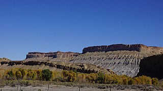
English: Capitol Reef National Park in south-central Utah is a region of cliffs, canyons, domes and bridges in the Waterpocket Fold, a wrinkle on the earth that runs almost 100 miles. The name "capitol" came from the resemblance of the white domes of Navajo Sandstone that looked like capitol building domes. "Reef" was derived from the rocky cliffs. These geologic formations were created by nearly 300 million years of geologic deposits, uplifts, and erosion. The sediments of the cliffs can look similar to a layer cake. |
| Date | Taken on 19 October 2016, 15:08:59 |
| Source | Own work |
| Author | NealVickers |
Licensing[edit]
.jpg&action=edit§ion=2)
I, the copyright holder of this work, hereby publish it under the following license:
This file is licensed under the Creative Commons Attribution-Share Alike 4.0 International license.
- You are free:
- to share – to copy, distribute and transmit the work
- to remix – to adapt the work
- Under the following conditions:
- attribution – You must give appropriate credit, provide a link to the license, and indicate if changes were made. You may do so in any reasonable manner, but not in any way that suggests the licensor endorses you or your use.
- share alike – If you remix, transform, or build upon the material, you must distribute your contributions under the same or compatible license as the original.

|
This image was uploaded as part of Wiki Loves Monuments 2018.
|
 |
File history
Click on a date/time to view the file as it appeared at that time.
| Date/Time | Thumbnail | Dimensions | User | Comment | |
|---|---|---|---|---|---|
| current | 01:13, 24 September 2018 | | 3,008 × 1,692 (3.29 MB) | NealVickers (talk | contribs) | User created page with UploadWizard |
You cannot overwrite this file.
File usage on Commons
There are no pages that use this file.
.jpg&oldid=817193317)