File:2006 North Korean nuclear test.svg
Jump to navigation
Jump to search

Size of this PNG preview of this SVG file: 473 × 408 pixels. Other resolutions: 278 × 240 pixels | 557 × 480 pixels | 890 × 768 pixels | 1,187 × 1,024 pixels | 2,374 × 2,048 pixels.
Original file (SVG file, nominally 473 × 408 pixels, file size: 71 KB)
Captions
Captions
Add a one-line explanation of what this file represents
Summary[edit]
| Description |
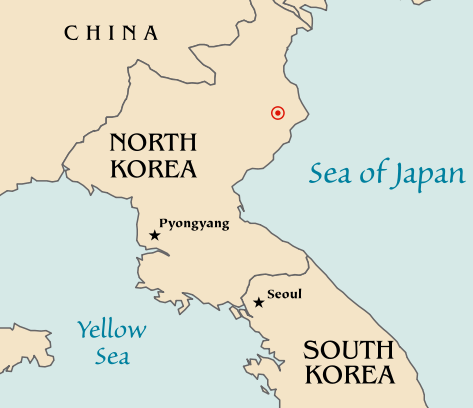
Map of the North Korean nuclear test of October 9, 2006. The red marker indicates the estimated location of the test (41.311°N, 129.114°E). Based off of maps from the CIA World Factbook. |
| Date | 10 October 2006 (original upload date) |
| Source | No machine-readable source provided. Own work assumed (based on copyright claims). |
| Author | No machine-readable author provided. Mobius assumed (based on copyright claims). |
| Other versions |
|


Licensing[edit]
| I, the copyright holder of this work, release this work into the public domain. This applies worldwide. In some countries this may not be legally possible; if so: I grant anyone the right to use this work for any purpose, without any conditions, unless such conditions are required by law. |
File history
Click on a date/time to view the file as it appeared at that time.
| Date/Time | Thumbnail | Dimensions | User | Comment | |
|---|---|---|---|---|---|
| current | 20:48, 10 October 2006 | | 473 × 408 (71 KB) | Mobius (talk | contribs) | + Crop area, proper license |
| 20:43, 10 October 2006 |  | 981 × 801 (71 KB) | Mobius (talk | contribs) | Map of the North Korean nuclear test of October 9, 2006. The red marker indicates the estimated location of the test (41.311°N, 129.114°E). Based off of maps from the CIA World Factbook. |
You cannot overwrite this file.
File usage on Commons
The following 5 pages use this file:
File usage on other wikis
The following other wikis use this file:
- Usage on ca.wikipedia.org
- Usage on en.wikipedia.org
- Usage on ia.wikipedia.org
- Usage on ko.wikipedia.org
- Usage on nl.wikipedia.org
- Usage on no.wikipedia.org
- Usage on pl.wikinews.org
- Usage on ta.wikinews.org
- Usage on www.wikidata.org