File:2002 Williams Fire on September 26.jpg
Jump to navigation
Jump to search

Size of this preview: 600 × 600 pixels. Other resolutions: 240 × 240 pixels | 480 × 480 pixels | 880 × 880 pixels.
Original file (880 × 880 pixels, file size: 858 KB, MIME type: image/jpeg)
Captions
Captions
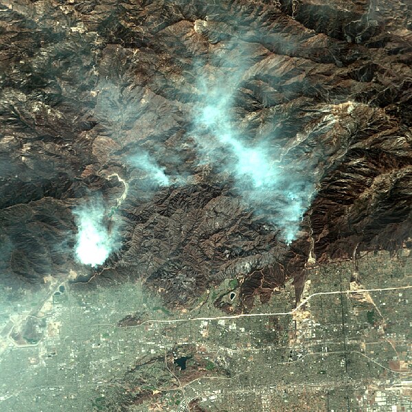
This NASA aerial image depicts the 2002 Williams Fire in the San Gabriel Mountains in Los Angeles County, California, on September 26, 2002, where it burned more than 38,000 acres and destroyed more than 70 structures.
Summary[edit]
| Description |
English: Original NASA Earth Observatory caption:
The Williams Fire northeast of Los Angeles continues to move through Angeles National Forest. As of Friday morning, September 27, the fire had spread to 35,000 acres and had forced the evacuation of more than 2,000 people from the National Forest and nearby suburbs. This image shows the area affected by the fire. The image was captured by an aircraft- mounted remote sensing device called MASTER, which stands for MODIS/ASTER Airborne Simulator. A simulator of the Moderate Resolution Imaging Spectroradiometer (MODIS) and Advanced Spaceborne Thermal Emission and Reflection Radiometer (ASTER) instruments on the Terra satellite, the device captured this image of the Williams Fire while flying on board NASA’s ER-2 aircraft on Thursday, September 26, 2002. In this true-color image, the burned area sits roughly in the center. The smoke roughly follows the perimeter of the fire in the north. Notice that the fire is burning right up against the San Gabriel reservoir on its western flank, which could create water quality problems down the road. The fire is burning very near several LA suburbs (bottom). |
| Date | |
| Source | https://earthobservatory.nasa.gov/images/10215/williams-fire-northeast-of-los-angeles |
| Author | MASTER instrument team and the NASA Dryden Airborne Science Program. |
Licensing[edit]
| This file is in the public domain in the United States because it was solely created by NASA. NASA copyright policy states that "NASA material is not protected by copyright unless noted". (See Template:PD-USGov, NASA copyright policy page or JPL Image Use Policy.) | ||
 |
Warnings:
|
File history
Click on a date/time to view the file as it appeared at that time.
| Date/Time | Thumbnail | Dimensions | User | Comment | |
|---|---|---|---|---|---|
| current | 20:26, 23 February 2024 | | 880 × 880 (858 KB) | Penitentes (talk | contribs) | Uploaded a work by MASTER instrument team and the NASA Dryden Airborne Science Program. from https://earthobservatory.nasa.gov/images/10215/williams-fire-northeast-of-los-angeles with UploadWizard |
You cannot overwrite this file.
File usage on Commons
There are no pages that use this file.
File usage on other wikis
The following other wikis use this file:
- Usage on en.wikipedia.org