File:1951 CIA map of Syria – principal Arab and Kurdish tribes, 1951.jpg
Jump to navigation
Jump to search

Size of this preview: 737 × 600 pixels. Other resolutions: 295 × 240 pixels | 590 × 480 pixels | 944 × 768 pixels | 1,258 × 1,024 pixels | 2,516 × 2,048 pixels | 5,868 × 4,776 pixels.
Original file (5,868 × 4,776 pixels, file size: 2.5 MB, MIME type: image/jpeg)
Captions
Captions
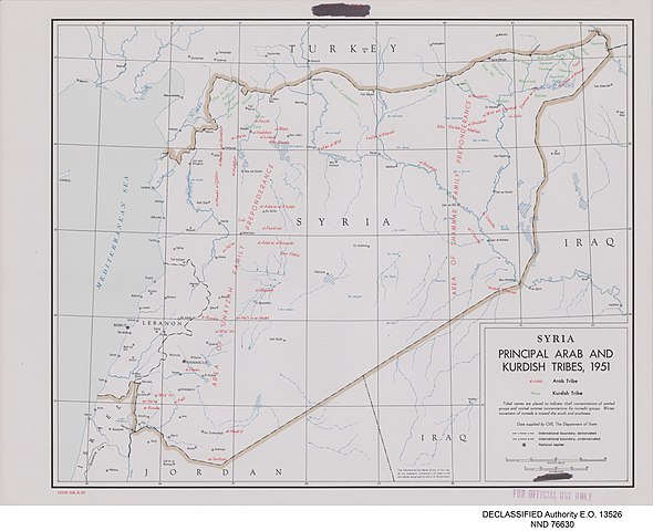
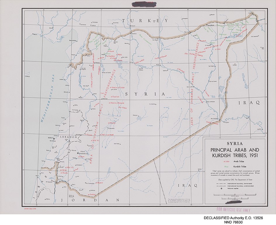
CIA map of Syria showing the "principal Arab and Kurdish tribes, 1951". Arab tribes' names are in red; Kurdish tribes' names are in green.
Summary[edit]
| Description |
English: Map of Syria prepared by the United States Central Intelligence Agency's Map Branch in 1951. Names of Arab tribes are written in red; names of Kurdish tribes are in green. Marked in red at bottom left: "12218 CIA, 6-52", and top centre: "RESTRICTED" and "SECURITY INFORMATION" (struck through). Stamped "FOR OFFICIAL USE ONLY" in red, bottom right. In the map area itself, the word "RESTRICTED" in red has been deleted from the legend at the bottom right. In the bottom centre is printed: "The international boundaries shown on this map do not necessarily correspond in all cases to the boundaries recognized by the U.S. Government." Digitally added to the image, beneath the map: "DECLASSIFIED Authority E.O. 13526" and "NND 76630". |
| Date | |
| Source |
United States National Archives Published Maps, 1947–2015 Record Group 263: Records of the Central Intelligence Agency, 1894–2002 https://catalog.archives.gov/id/175515101 (National Archives Identifier: 175515101) |
| Author | Map Service Center, Central Intelligence Agency, United States National Security Council |
| Other versions |
.jpg)
.jpg)
.jpg)
.jpg)
.jpg)
Licensing[edit]
| This image is a work of a Central Intelligence Agency employee, taken or made as part of that person's official duties. As a Work of the United States Government, this image or media is in the public domain in the United States.
|

|
File history
Click on a date/time to view the file as it appeared at that time.
| Date/Time | Thumbnail | Dimensions | User | Comment | |
|---|---|---|---|---|---|
| current | 04:32, 24 May 2021 | | 5,868 × 4,776 (2.5 MB) | GPinkerton (talk | contribs) | Uploaded a work by Map Service Center, Central Intelligence Agency, United States National Security Council from United States National Archives Published Maps, 1947–2015 Record Group 263: Records of the Central Intelligence Agency, 1894–2002 https://catalog.archives.gov/id/175515101 (National Archives Identifier: 175515101) with UploadWizard |
You cannot overwrite this file.
File usage on Commons
The following 5 pages use this file:
- File:1951 CIA map of Syria – principal Arab and Kurdish tribes, 1951 (Kurdish tribes of the Upper Euphrates – Jarablus area).jpg
- File:1951 CIA map of Syria – principal Arab and Kurdish tribes, 1951 (Kurdish tribes of the Upper Jazira).jpg
- File:1951 CIA map of Syria – principal Arab and Kurdish tribes, 1951 (Syrian Kurdistan detail).jpg
- File:1951 CIA map of Syria – principal Arab and Kurdish tribes, 1951 (detail – Kurdish tribes of the Kurd Dagh).jpg
- File:1951 CIA map of Syria – principal Arab and Kurdish tribes, 1951 (margins cropped).jpg