File:1909 Colorado Springs Benford-Bryan map - Institute Heights.png
Jump to navigation
Jump to search

Size of this preview: 800 × 510 pixels. Other resolutions: 320 × 204 pixels | 640 × 408 pixels | 972 × 620 pixels.
Original file (972 × 620 pixels, file size: 1.28 MB, MIME type: image/png)
Captions
Captions
Add a one-line explanation of what this file represents
Summary[edit]
| Description |
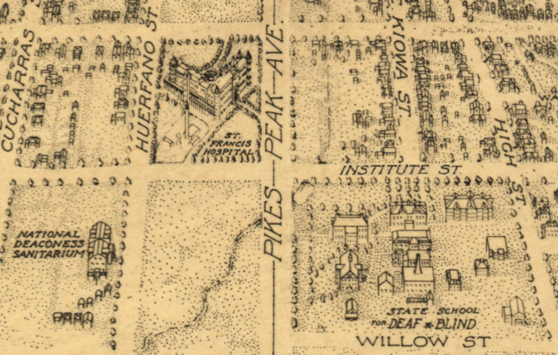
English: The vertical line on "Pikes Peak Ave" indicates the east-west Knob Hill trolley line of the Colorado Springs and Interurban Railway
c. 1903 as the
|
| Date | Unknown date--image has anachronostic features/labels indicating it was made earlier than 1909 |
| Source | from 1909 Benford-Bryan version of Birds-Eye View of Colorado Springs (received by Library of Congress "Mar 29, 1909") |
| Author | unknown cartographers |
| Permission (Reusing this file) |
published before 1923 in the United States |
Licensing[edit]
This media file is in the public domain in the United States. This applies to U.S. works where the copyright has expired, often because its first publication occurred prior to January 1, 1929, and if not then due to lack of notice or renewal. See this page for further explanation.
|
 | |
 |
This image might not be in the public domain outside of the United States; this especially applies in the countries and areas that do not apply the rule of the shorter term for US works, such as Canada, Mainland China (not Hong Kong or Macao), Germany, Mexico, and Switzerland. The creator and year of publication are essential information and must be provided. See Wikipedia:Public domain and Wikipedia:Copyrights for more details.
|
File history
Click on a date/time to view the file as it appeared at that time.
| Date/Time | Thumbnail | Dimensions | User | Comment | |
|---|---|---|---|---|---|
| current | 18:04, 9 December 2013 | | 972 × 620 (1.28 MB) | 30 SW (talk | contribs) | {{Information |Description ={{en|1=The vertical line on "Pikes Peak Ave" indicates the east-west Knob Hill trolley line of the Colorado Springs and Interurban Railway {{c.|1903}} as the *"National Deaconess Sanitarium" (lower left) was renamed... |
You cannot overwrite this file.
File usage on Commons
There are no pages that use this file.
File usage on other wikis
The following other wikis use this file:
- Usage on en.wikipedia.org