File:1889 Vuillemin Map of Paris, France - Geographicus - Paris-vuillemin-1889.jpg
Original file (6,000 × 4,173 pixels, file size: 8.24 MB, MIME type: image/jpeg)
Captions
Captions
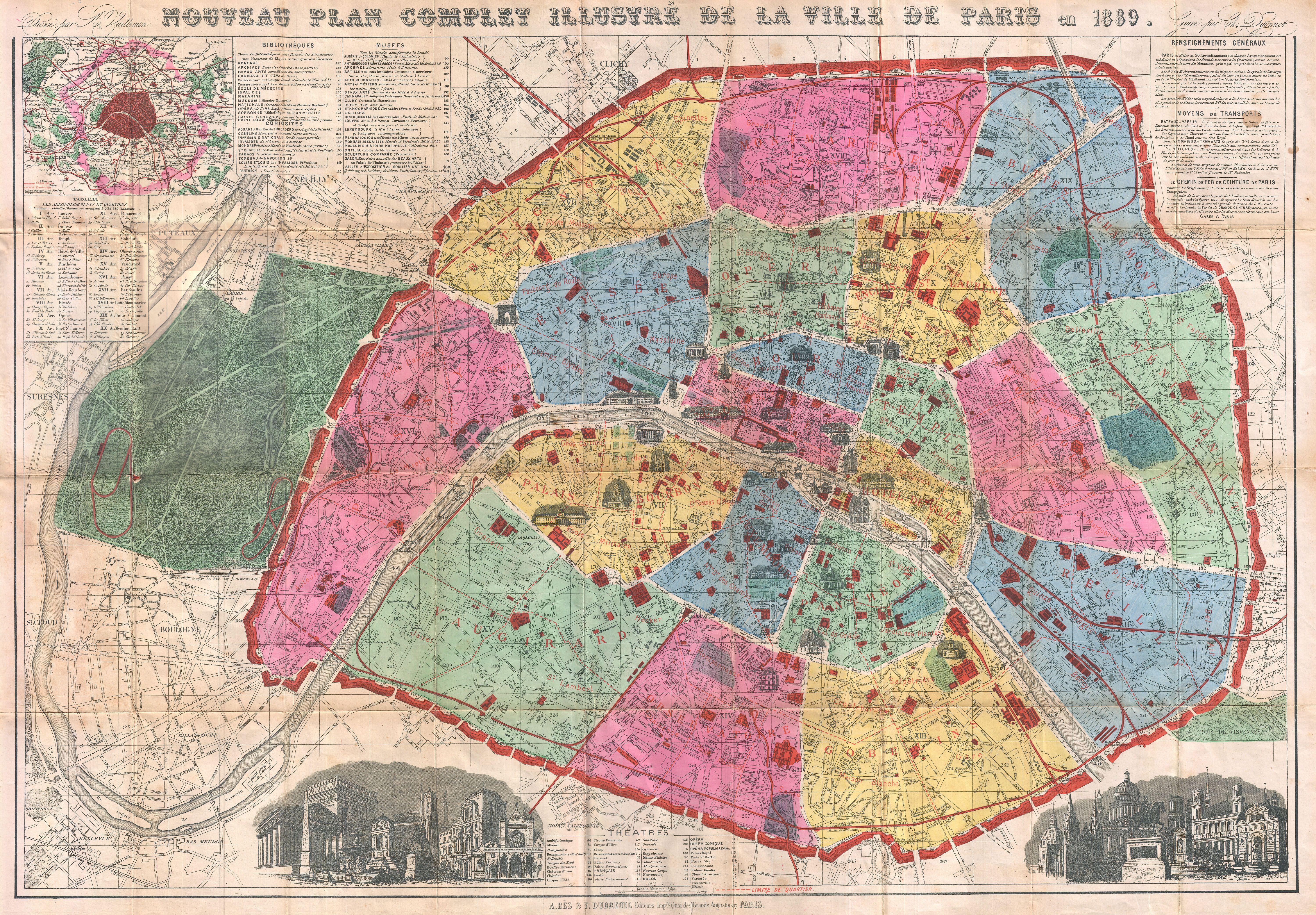
| Nouveau Plan Complet Illustre de la Ville de Paris en 1889. | ||||||
|---|---|---|---|---|---|---|
| Artist | ||||||
| Title |
Nouveau Plan Complet Illustre de la Ville de Paris en 1889. |
|||||
| Description |
English: A bright, colorful map of Paris made by A. Vuillemin for the 1889 Exposition Universelle (World's Fair). Depicts the walled center of Paris as well as its immediate vicinity to the west, including the Bois de Boulogne. Important buildings are noted throughout and often shown in profile. The park where the 1880 Exposition Universelle was held, named the Champ de Mars, is noted. At the western end of the Champ de Mars, the Eiffel Tower is also noted as Tour Eiffel 300 Meters. It is actually 324 meters. The Eiffel Tower was built to be the entry arch to the 1889 Exposition. That the Eiffel Tower is not drawn in profile, as are so many of Paris' great monuments, is a reminder that, at the time, the structure was considered to be ugly. The lower right and left quadrants feature architectural views that include many of Paris' most notable buildings out of context. Indexes scattered around the map indentify theaters, libraries, museums, railroad lines and curiosities. All text in French. Color coded by arrondissement. Drawn by A. Vuillemin and engraved by Charles Dyonnet for publication by A. Bes and F. Dubreuil. |
|||||
| Date | 1889 (dated) | |||||
| Dimensions | height: 24 in (60.9 cm); width: 34 in (86.3 cm) | |||||
| Accession number |
Geographicus link: Paris-vuillemin-1889 |
|||||
| Source/Photographer |
|
|||||
| Permission (Reusing this file) |
|
|||||
File history
Click on a date/time to view the file as it appeared at that time.
| Date/Time | Thumbnail | Dimensions | User | Comment | |
|---|---|---|---|---|---|
| current | 01:07, 24 March 2011 | | 6,000 × 4,173 (8.24 MB) | BotMultichillT (talk | contribs) | {{subst:User:Multichill/Geographicus |link=http://www.geographicus.com/P/AntiqueMap/Paris-vuillemin-1889 |product_name=1889 Vuillemin Map of Paris, France |map_title=Nouveau Plan Complet Illustre de la Ville de Paris en 1889. |description=A bright and stu |
You cannot overwrite this file.
File usage on Commons
The following page uses this file:
File usage on other wikis
The following other wikis use this file:
- Usage on fr.wikipedia.org