File:1865 Hall Map of Frobisher Bay, Baffin Island, Canada (important Arctic Exploration Map) - Geographicus - FrobisherBay-hall-1865.jpg

Original file (4,000 × 2,906 pixels, file size: 2.97 MB, MIME type: image/jpeg)
Captions
Captions
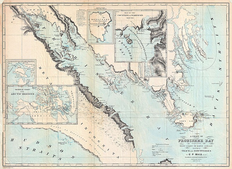
| A Chart of Frobisher Bay and part of the West Coast of Davis Strait showing the Track and Discoveries of C. F. Hall on his Franklin Research Expeditions during the years of 1860 - 61 - 62. | ||||||
|---|---|---|---|---|---|---|
| Artist | ||||||
| Title |
A Chart of Frobisher Bay and part of the West Coast of Davis Strait showing the Track and Discoveries of C. F. Hall on his Franklin Research Expeditions during the years of 1860 - 61 - 62. |
|||||
| Description |
English: This is a rare and fascinating 1864 map of Frobisher Bay, Baffin Island and the Davis Straits, Canada prepared to illustrate the explorations and discoveries of Charles Francis Hall. Hall is a fascinating figure in Arctic Exploration. In 1860 Hall, at the time a Newspaper publisher, became obsessed with the idea of rescuing the missing Arctic expedition of English nobleman Sir John Franklin. Despite a lack of substantial funding or experience in the Arctic, Hall set out for Greenland with the plan to use local guides and techniques to aid in his explorations. The full story of Hall’s fascinating adventures cannot be contained here, nonetheless, after several years in the Arctic, he did in fact discover the sad fate of Franklin’s expedition – starvation and death. This however was not his most notable achievement. Rather, it is his correctly identifying Frobisher Strait as a Bay on Baffin Island. The English navigator Martin Frobisher first explored this area in 1576 in the search of a Northwest Passage. He described the discovery of a large body of open water to the west of Baffin Island. Desirous of a Northwest Passage, Frobisher assumed that the Bay was in fact a strait separating Baffin Island from another unknown island. It was not until Hall explored the area in 1860 that it became clear that Baffin Island was much larger than presumed and that the supposed “strait” was little more than a large bay. This is consequently one of the first published maps to show this Arctic region with relative accuracy. Published to supplement C. F. Hall's account of the “Franklin Research Expedition” in 1865. |
|||||
| Date | 1864 (dated 1860 - 61 - 62) | |||||
| Dimensions | height: 16.5 in (41.9 cm); width: 22.5 in (57.1 cm) | |||||
| Accession number |
Geographicus link: FrobisherBay-hall-1865 |
|||||
| Source/Photographer |
Hall, C. F., Arctic Researches and Life Among the Esquimaux. (New York, 1865)
|
|||||
| Permission (Reusing this file) |
|
|||||
File history
Click on a date/time to view the file as it appeared at that time.
| Date/Time | Thumbnail | Dimensions | User | Comment | |
|---|---|---|---|---|---|
| current | 17:34, 22 March 2011 | | 4,000 × 2,906 (2.97 MB) | BotMultichillT (talk | contribs) | {{subst:User:Multichill/Geographicus |link=http://www.geographicus.com/P/AntiqueMap/FrobisherBay-hall-1865 |product_name=1865 Hall Map of Frobisher Bay, Baffin Island, Canada (important Arctic Exploration Map) |map_title=A Chart of Frobisher Bay and part |
You cannot overwrite this file.
File usage on Commons
The following page uses this file:
_-_Geographicus_-_FrobisherBay-hall-1865.jpg)
File usage on other wikis
The following other wikis use this file:
- Usage on bg.wikipedia.org
_-_Geographicus_-_FrobisherBay-hall-1865.jpg&oldid=804330227)