File:1864 Johnson Map of Virginia, West Virginia, Maryland, and Delaware - Geographicus - VirginiaWestVirginia-johnson-1864.jpg
Jump to navigation
Jump to search

Size of this preview: 800 × 589 pixels. Other resolutions: 320 × 236 pixels | 640 × 471 pixels | 1,024 × 754 pixels | 1,280 × 942 pixels | 2,560 × 1,884 pixels | 4,500 × 3,312 pixels.
Original file (4,500 × 3,312 pixels, file size: 5.76 MB, MIME type: image/jpeg)
Captions
Captions
Add a one-line explanation of what this file represents
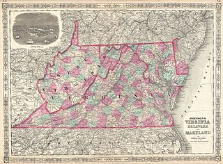
| Alvin Jewett Johnson: Johnson's Virginia Delaware and Maryland.
( |
|||||||||||||||||||||||
|---|---|---|---|---|---|---|---|---|---|---|---|---|---|---|---|---|---|---|---|---|---|---|---|
| Artist |
|
||||||||||||||||||||||
| Title |
Johnson's Virginia Delaware and Maryland. |
||||||||||||||||||||||
| Description |
English: This is a beautifully hand colored 1864 lithograph map of the Virginia, Delaware, Maryland and West Virginia. Map shows cities, counties, topographical features, railways, ferries and roads with color coding at the county level. Due to the events of the American Civil War and the separation of Virginia and West Virginia, Johnson’s map of this region went through numerous different editions from 1861 onwards. This edition, 1864, is particularly ephemeral and features an engraved view of Fortress Monroe, Virginia. Published by A. J. Johnson and Ward as plates 33-34 in the 1864 edition of Johnson’s New Illustrated Family Atlas . This is the first edition of the Johnson’s Atlas to bear the Johnson & Ward imprint and the only edition to identify the firm as the “Successors to Johnson and Browning (Successors to J. H. Colton and Company)”. |
||||||||||||||||||||||
| Date | 1864 (undated) | ||||||||||||||||||||||
| Dimensions | height: 17.5 in (44.4 cm); width: 23.5 in (59.6 cm) | ||||||||||||||||||||||
| Accession number |
Geographicus link: VirginiaWestVirginia-johnson-1864 |
||||||||||||||||||||||
| Source/Photographer |
Johnson, A. J., Johnson's New Illustrated (Steel Plate) Family Atlas of The World with Physical Geography, and with Descriptions Geographical, Statistical, and Historic including The Latest Federal Census, A Geographical Index, and a Chronological History of the Civil War in America, (first Johnson and Ward), 1864.
|
||||||||||||||||||||||
| Permission (Reusing this file) |
|
||||||||||||||||||||||
File history
Click on a date/time to view the file as it appeared at that time.
| Date/Time | Thumbnail | Dimensions | User | Comment | |
|---|---|---|---|---|---|
| current | 01:35, 25 March 2011 | | 4,500 × 3,312 (5.76 MB) | BotMultichillT (talk | contribs) | {{subst:User:Multichill/Geographicus |link=http://www.geographicus.com/P/AntiqueMap/VirginiaWestVirginia-johnson-1864 |product_name=1864 Johnson Map of Virginia, West Virginia, Maryland, and Delaware |map_title=Johnson's Virginia Delaware and Maryland. |d |
You cannot overwrite this file.
File usage on Commons
The following page uses this file: