File:1862 Johnson Map of Kansas, Nebraska and Dakota - Geographicus - NEKADK-johnson-1862.jpg
Jump to navigation
Jump to search

Size of this preview: 741 × 600 pixels. Other resolutions: 297 × 240 pixels | 593 × 480 pixels | 949 × 768 pixels | 1,265 × 1,024 pixels | 2,530 × 2,048 pixels | 4,000 × 3,238 pixels.
Original file (4,000 × 3,238 pixels, file size: 4.44 MB, MIME type: image/jpeg)
Captions
Captions
Add a one-line explanation of what this file represents
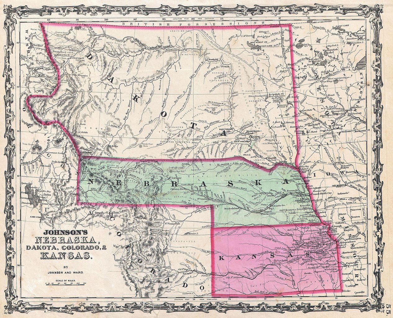
| Alvin Jewett Johnson: Johnson's Nebraska, Dakota, Colorado, & Kansas.
( |
|||||||||||||||||||||||
|---|---|---|---|---|---|---|---|---|---|---|---|---|---|---|---|---|---|---|---|---|---|---|---|
| Artist |
|
||||||||||||||||||||||
| Title |
Johnson's Nebraska, Dakota, Colorado, & Kansas. |
||||||||||||||||||||||
| Description |
English: From the 1862 Johnson and Ward edition of the Atlas , this is one of the rarest and most desirable states of the Johnson’s Dakota, Nebraska and Kansas map. In this example Nebraska is drawn with a long panhandle extending from Iowa all the way to Fremont’s Peak. To the north, Dakota is a massive and newly partitioned territory extending from Minnesota to the Rocky Mountains and from Nebraska to the border with British Columbia. Shows an embryonic Colorado with a few towns and North Park, Middle Park and South Park noted. This map also notes the three routes proposed for the Pacific Railroad: the Governor Stevens route through Dakota, the Lieutenant Beswith route through Nebraska, and the Captain Gunnison route through Colorado and Kansas . References various American Indian Nations throughout as well as countless geographical features including mountains, lakes, passes, rivers, rapids, etc. Features the strapwork style border common to Johnson’s atlas work from 1860 to 1863. Published by A. J. Johnson and Ward as plate number 55 in the 1862 edition of Johnson’s New Illustrated Family Atlas . |
||||||||||||||||||||||
| Date | 1862 (undated) | ||||||||||||||||||||||
| Dimensions | height: 12.5 in (31.7 cm); width: 16 in (40.6 cm) | ||||||||||||||||||||||
| Accession number |
Geographicus link: NEKADK-johnson-1862 |
||||||||||||||||||||||
| Source/Photographer |
Johnson, A. J., Johnson's New Illustrated (Steel Plate) Family Atlas with Descriptions, Geographical, Statistical, and Historical. (1862 A. J. Johnson & Ward edition)
|
||||||||||||||||||||||
| Permission (Reusing this file) |
|
||||||||||||||||||||||
File history
Click on a date/time to view the file as it appeared at that time.
| Date/Time | Thumbnail | Dimensions | User | Comment | |
|---|---|---|---|---|---|
| current | 21:05, 22 March 2011 | | 4,000 × 3,238 (4.44 MB) | BotMultichillT (talk | contribs) | {{subst:User:Multichill/Geographicus |link=http://www.geographicus.com/P/AntiqueMap/NEKADK-johnson-1862 |product_name=1862 Johnson Map of Kansas, Nebraska and Dakota |map_title=Johnson's Nebraska, Dakota, Colorado, & Kansas. |description=From the 1862 Joh |
You cannot overwrite this file.
File usage on Commons
The following page uses this file: