File:1850 Meyer Comparative Chart of World Mountains - Geographicus - Mountains-meyer-1850.jpg

Original file (3,000 × 2,578 pixels, file size: 3.15 MB, MIME type: image/jpeg)
Captions
Captions
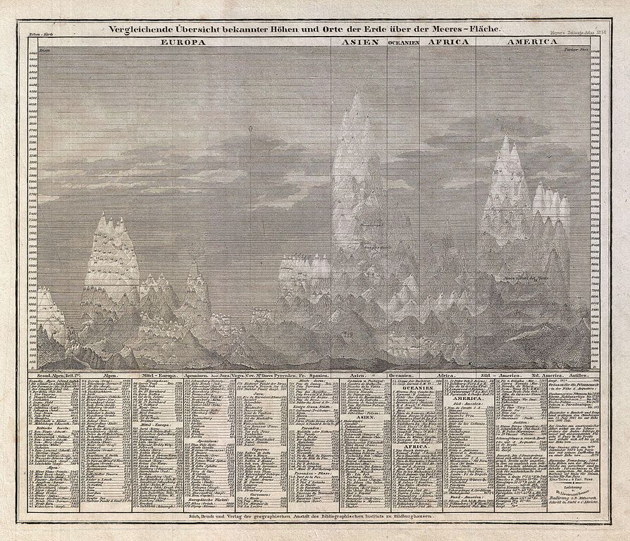
| Vergleichende Übersicht bekannter Höhen und Orte der Erde über der Meeres-Fläche | ||||||
|---|---|---|---|---|---|---|
| Artist | ||||||
| Title |
Vergleichende Übersicht bekannter Höhen und Orte der Erde über der Meeres-Fläche |
|||||
| Description |
English: An interesting c. 1850 German take on the comparative mountains chart by Joseph Meyer. Identifies some 400 mountains drawn in proximity to one another and subdivided by continent. Dhaulagiri, in the Nepali Himalayas is identified as the world's greatest peak. The names and elevations of the various other peaks shown are identified textually at the base of the chart proper. Published in Meyer's c. 1850 Groschen-Atlas . |
|||||
| Date | circa 1850(undated) | |||||
| Dimensions | height: 9 in (22.8 cm); width: 10.5 in (26.6 cm) | |||||
| Accession number |
Geographicus link: Mountains-meyer-1850 |
|||||
| Source/Photographer |
Meyer, J., Meyer's Groschen-Atlas aller Länder uns Staaten der Erde, mit Physikalischen und Himmels-Karten in 154 Blättern, 1850.
|
|||||
| Permission (Reusing this file) |
|
|||||
File history
Click on a date/time to view the file as it appeared at that time.
| Date/Time | Thumbnail | Dimensions | User | Comment | |
|---|---|---|---|---|---|
| current | 04:44, 24 March 2011 | | 3,000 × 2,578 (3.15 MB) | BotMultichillT (talk | contribs) | {{subst:User:Multichill/Geographicus |link=http://www.geographicus.com/P/AntiqueMap/Mountains-meyer-1850 |product_name=1850 Meyer Comparative Chart of World Mountains |map_title=Vergleichende Übersicht bekannter Höhen und Orte der Erde über der Meeres- |
You cannot overwrite this file.
File usage on Commons
The following page uses this file: