File:1849 Land Survey Map of Michigan Upper Peninsula - Geographicus - Michigan-ls-1850.jpg

Original file (3,000 × 1,810 pixels, file size: 964 KB, MIME type: image/jpeg)
Captions
Captions
| Michigan Upper Peninsula. | ||||||
|---|---|---|---|---|---|---|
| Artist | ||||||
| Title |
Michigan Upper Peninsula. |
|||||
| Description |
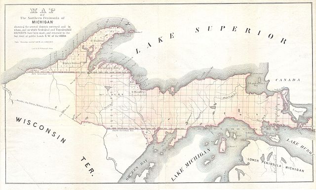
English: This is in unusual General Land Survey map of the Northern Peninsula of Michigan. Offers considerable decorative and topographic detail for a GLS map. Small steam ship depicted of Manitou Island. By Weber and Balto. |
|||||
| Date | 1849 | |||||
| Dimensions | height: 10 in (25.4 cm); width: 17 in (43.1 cm) | |||||
| Accession number |
Geographicus link: Michigan-ls-1850 |
|||||
| Source/Photographer |
|
|||||
| Permission (Reusing this file) |
|
|||||
File history
Click on a date/time to view the file as it appeared at that time.
| Date/Time | Thumbnail | Dimensions | User | Comment | |
|---|---|---|---|---|---|
| current | 07:52, 16 March 2011 | | 3,000 × 1,810 (964 KB) | BotMultichill (talk | contribs) | {{subst:User:Multichill/Geographicus |link=http://www.geographicus.com/P/AntiqueMap/Michigan-ls-1850 |product_name=1849 Land Survey Map of Michigan Upper Peninsula |map_title=Michigan Upper Peninsula. |description=This is in unusual General Land Survey ma |
You cannot overwrite this file.
File usage on Commons
The following page uses this file:
File usage on other wikis
The following other wikis use this file:
- Usage on en.wikipedia.org