File:1840 French map of the world depicting the territories of the British, French and Russian Empires.jpg
Jump to navigation
Jump to search

Size of this preview: 800 × 587 pixels. Other resolutions: 320 × 235 pixels | 640 × 470 pixels | 1,024 × 751 pixels | 1,280 × 939 pixels | 2,560 × 1,878 pixels | 15,366 × 11,273 pixels.
Original file (15,366 × 11,273 pixels, file size: 36.22 MB, MIME type: image/jpeg)
Captions
Captions
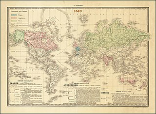
1840 French map of the world depicting the territories of the British, French and Russian Empires
Summary[edit]
| Warning | The original file is very high-resolution. It might not load properly or could cause your browser to freeze when opened at full size. |
|---|
| Description |
English: 1840 French map of the world depicting the territories of the British, French and Russian Empires |
| Date | |
| Source | https://www.raremaps.com/gallery/detail/64623/world-map-1840-kaeppelin |
| Author | Kaeppelin |
Licensing[edit]
|
This work is in the public domain in its country of origin and other countries and areas where the copyright term is the author's life plus 70 years or fewer. This work is in the public domain in the United States because it was published (or registered with the U.S. Copyright Office) before January 1, 1929. | |
| This file has been identified as being free of known restrictions under copyright law, including all related and neighboring rights. | |
File history
Click on a date/time to view the file as it appeared at that time.
| Date/Time | Thumbnail | Dimensions | User | Comment | |
|---|---|---|---|---|---|
| current | 12:50, 3 April 2020 | | 15,366 × 11,273 (36.22 MB) | Balkanique (talk | contribs) | Uploaded a work by Kaeppelin from https://www.raremaps.com/gallery/detail/64623/world-map-1840-kaeppelin with UploadWizard |
You cannot overwrite this file.
File usage on Commons
There are no pages that use this file.