File:1831 Hooker Map of New York City (1871 reissue) - Geographicus - NewYork-hooker-1871.jpg
Jump to navigation
Jump to search

Size of this preview: 478 × 600 pixels. Other resolutions: 191 × 240 pixels | 383 × 480 pixels | 612 × 768 pixels | 816 × 1,024 pixels | 1,633 × 2,048 pixels | 3,000 × 3,763 pixels.
Original file (3,000 × 3,763 pixels, file size: 2.6 MB, MIME type: image/jpeg)
Captions
Captions
Add a one-line explanation of what this file represents
Summary[edit]
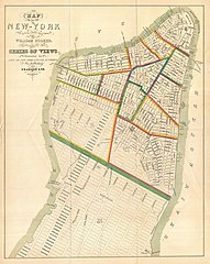
| William Hooker: Map of the City of New-York Compiled & Surveyed by William Hooker.
( |
||||||||||||||
|---|---|---|---|---|---|---|---|---|---|---|---|---|---|---|
| Artist |
|
|||||||||||||
| Title |
Map of the City of New-York Compiled & Surveyed by William Hooker. |
|||||||||||||
| Description |
English: This is an unusual map of New York City first issued in 1831 by William Hooker and Peabody. This example is a reissue, apparently from the same plate, dating to the Hardy edition of the Manual of the Corporation of New York , 1871. Perhaps this map’s most striking feature is the fact that the orientation of the map and the orientation of the title are at odds. We have stumbled across this piece a few times from both the first and second issues, and all examples exhibit the same conflicting orientation. Since this map was originally published to supplement a book of pictures and views of New York and vicinity by T.S. Fay, we can speculate that the limited budget of the publisher, Peabody and Company, made a reissue of the map impractical despite the orientation error. Cartographically this map claims to be the culmination of original survey work accomplished by William Hooker, but to our eye is a clear copy of Burr’s contemporaneous pocket map of New York City. Hooker’s map, like Burr’s names all streets and identifies city wards from the Battery to 52nd Street. Important buildings, docks, topographical features, and parks are noted. Though originally issued in 1831 for T.S. Fay’s Views in the City of New-York and its Environs , this example is a reissue prepared by John Hardy, Clerk of the Common Council, for the 1871 edition of the Manual of the Corporation of New York . |
|||||||||||||
| Date | 1831 (1871 reissue) | |||||||||||||
| Dimensions | height: 16 in (40.6 cm); width: 12.5 in (31.7 cm) | |||||||||||||
| Accession number |
Geographicus link: NewYork-hooker-1871 |
|||||||||||||
| Source/Photographer |
Hardy, John , ed. (1870) Manual of the Corporation of the City of New York, New York City: Common Council, before p. 905 [aka Valentine's Manual (1870)]. Also in: Fay, T. S., Views in the City of New-York and its Environs, 1831.
|
|||||||||||||
| Permission (Reusing this file) |
|
|||||||||||||
| Other versions |
 |
|||||||||||||


_-_Geographicus_-_NewYork-hooker-1871.jpg&action=edit§ion=1)
File history
Click on a date/time to view the file as it appeared at that time.
| Date/Time | Thumbnail | Dimensions | User | Comment | |
|---|---|---|---|---|---|
| current | 23:04, 24 March 2011 | | 3,000 × 3,763 (2.6 MB) | BotMultichillT (talk | contribs) | {{subst:User:Multichill/Geographicus |link=http://www.geographicus.com/P/AntiqueMap/NewYork-hooker-1871 |product_name=1831 Hooker Map of New York City (1871 reissue) |map_title=Map of the City of New-York Compiled & Surveyed by William Hooker. |descriptio |
You cannot overwrite this file.
File usage on Commons
The following 2 pages use this file:
_-_Geographicus_-_NewYork-hooker-1871.jpg)
File usage on other wikis
The following other wikis use this file:
- Usage on en.wikipedia.org
- Usage on ru.wikipedia.org
- Usage on uk.wikipedia.org
_-_Geographicus_-_NewYork-hooker-1871.jpg&oldid=830025779)