File:1815 tambora explosion B.png
Jump to navigation
Jump to search

Size of this preview: 800 × 358 pixels. Other resolutions: 320 × 143 pixels | 640 × 286 pixels | 1,200 × 537 pixels.
Original file (1,200 × 537 pixels, file size: 247 KB, MIME type: image/png)
Captions
Captions
Add a one-line explanation of what this file represents
| Description |
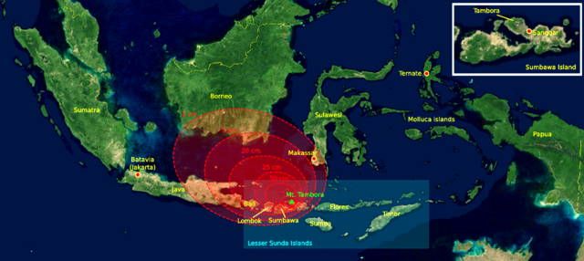
The 1815 Mount Tambora eruption. The red areas are maps of the thickness of volcanic ashfall. Deutsch: Die Eruption des Mount Tambora im Jahr 1815. Die roten Bereiche sind Karten mit der Dicke des vulkanischen Aschefalls. |
||||||||
| Source | The base map was taken from NASA picture Image:Indonesia_BMNG.png and the isopach maps were traced from Oppenheimer (2003).[1] | ||||||||
| Author | myself | ||||||||
| Permission (Reusing this file) |
|
||||||||
| Other versions | 1815_tambora_explosion.png=Original (This version was modified by Xavax 16:44, 5 September 2007 (UTC)) |

References[edit]
- ↑ Oppenheimer, Clive (2003). "Climatic, environmental and human consequences of the largest known historic eruption: Tambora volcano (Indonesia) 1815". Progress in Physical Geography 27 (2): 230-259.
File history
Click on a date/time to view the file as it appeared at that time.
| Date/Time | Thumbnail | Dimensions | User | Comment | |
|---|---|---|---|---|---|
| current | 16:44, 5 September 2007 | | 1,200 × 537 (247 KB) | Xavax (talk | contribs) | {{Information |Description= The 1815 Mount Tambora eruption. The red areas are maps of the thickness of volcanic ashfall. |Source=The base map was taken from NASA picture Image:Indonesia_BMNG.png and the isopach maps were traced |
You cannot overwrite this file.
File usage on Commons
The following 2 pages use this file:
File usage on other wikis
The following other wikis use this file:
- Usage on br.wikipedia.org
- Usage on cs.wikipedia.org
- Usage on da.wikipedia.org
- Usage on de.wikipedia.org
- Usage on es.wikipedia.org
- Usage on eu.wikipedia.org
- Usage on fi.wikipedia.org
- Usage on fr.wikipedia.org
- Usage on it.wikipedia.org
- Usage on ja.wikipedia.org
- Usage on mk.wikipedia.org
- Usage on uk.wikipedia.org
- Usage on www.wikidata.org
- Usage on zh.wikipedia.org