File:1806 Cary Map of New England, New York, Pennsylvania, New Jersey and Virginia - Geographicus - NYVTNVA-cary-1806.jpg
Jump to navigation
Jump to search
Size of this preview: 677 × 599 pixels. Other resolutions: 271 × 240 pixels | 542 × 480 pixels | 868 × 768 pixels | 1,157 × 1,024 pixels | 2,314 × 2,048 pixels | 5,000 × 4,426 pixels.
Original file (5,000 × 4,426 pixels, file size: 7.34 MB, MIME type: image/jpeg)
Captions
Captions
Add a one-line explanation of what this file represents
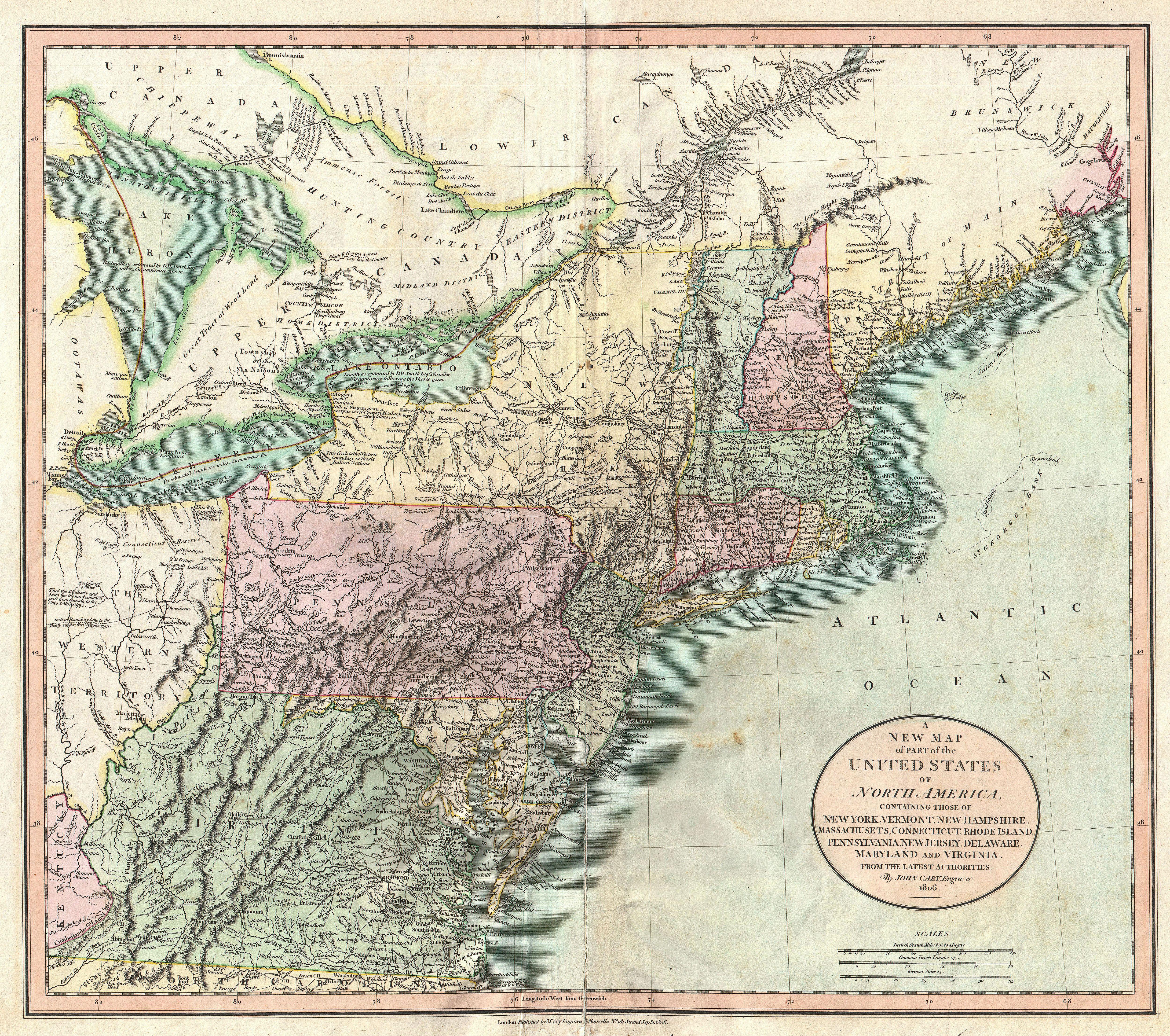
| John Cary: A New Map of Part of the United States of North America, Containing those of New York, Vermont, New Hampshire, Massachusets, Connecticut, Rhode Island, Pennsylvania, New Jersey, Delaware, Maryland and Virginia.
( |
||||||||||||||||||||||||||
|---|---|---|---|---|---|---|---|---|---|---|---|---|---|---|---|---|---|---|---|---|---|---|---|---|---|---|
| Artist |
|
|||||||||||||||||||||||||
| Title |
A New Map of Part of the United States of North America, Containing those of New York, Vermont, New Hampshire, Massachusets, Connecticut, Rhode Island, Pennsylvania, New Jersey, Delaware, Maryland and Virginia. |
|||||||||||||||||||||||||
| Description |
English: Published by John Cary in 1806, this is one of the most interesting atlas maps of the northeastern parts of the United States to appear in the early 19th century. Covers from Lake Huron southward as far as Virginia and North Carolina and eastward as far as the Atlantic Ocean. Includes the modern day states of Maine, New Hampshire, New York, Vermont, Massachusetts, Connecticut, Rhode Island, Pennsylvania, New Jersey, Maryland, Delaware, Virginia, West Virginia and Ohio as well as parts of Ontario and Quebec. The most interesting part of this map is the Northwest which is dedicated to the Great Lakes and the Western Territory. Notes the Connecticut’s Western Reserve in what is today Ohio. The reserve, formally ceded to Connecticut after the Yankee-Pennamite Wars, was the last remnant of Connecticut’s old colonial sea-to-sea grant of all territory falling between the 41st and 42nd parallels. Includes numbers references to the American Indian nations occupying the region, including the Chippewa, the Ootawas, and the Six Nations. Also notes the important cod fishing banks off Massachusetts and Maine. Prepared in 1806 by John Cary for issue in his magnificent 1808 New Universal Atlas . |
|||||||||||||||||||||||||
| Date | 1806 (dated) | |||||||||||||||||||||||||
| Dimensions | height: 18 in (45.7 cm); width: 20.7 in (52.7 cm) | |||||||||||||||||||||||||
| Accession number |
Geographicus link: NYVTNVA-cary-1806 |
|||||||||||||||||||||||||
| Source/Photographer |
Cary, John, Cary's New Universal Atlas, containing distinct maps of all the principal states and kingdoms throughout the World. From the latest and best authorities extant. London: Printed for J. Cary, Engraver and Map-seller, No. 181, near Norfolk Street, Strand, 1808.
|
|||||||||||||||||||||||||
| Permission (Reusing this file) |
|
|||||||||||||||||||||||||
File history
Click on a date/time to view the file as it appeared at that time.
| Date/Time | Thumbnail | Dimensions | User | Comment | |
|---|---|---|---|---|---|
| current | 09:40, 22 March 2011 | | 5,000 × 4,426 (7.34 MB) | BotMultichill (talk | contribs) | {{subst:User:Multichill/Geographicus |link=http://www.geographicus.com/P/AntiqueMap/NYVTNVA-cary-1806 |product_name=1806 Cary Map of New England, New York, Pennsylvania, New Jersey and Virginia |map_title=A New Map of Part of the United States of North Am |
You cannot overwrite this file.
File usage on Commons
The following page uses this file: