File:1797 Tardieu Map of Champagne, France - Geographicus - Champagne-tardieu-1797.jpg
Jump to navigation
Jump to search

Size of this preview: 729 × 599 pixels. Other resolutions: 292 × 240 pixels | 584 × 480 pixels | 934 × 768 pixels | 1,246 × 1,024 pixels | 2,491 × 2,048 pixels | 6,000 × 4,933 pixels.
Original file (6,000 × 4,933 pixels, file size: 6.08 MB, MIME type: image/jpeg)
Captions
Captions
Add a one-line explanation of what this file represents
Summary[edit]
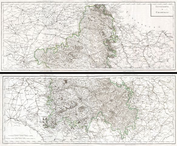
| Pierre François Tardieu: Français : Carte Générale de ChampagneEnglish: General map of the ChampagneDeutsch: Generalkarte der Champagne
( |
||||||||||||||||||
|---|---|---|---|---|---|---|---|---|---|---|---|---|---|---|---|---|---|---|
| Artist |
|
|||||||||||||||||
| Title |
Français : Carte Générale de Champagne English: General map of the Champagne Deutsch: Generalkarte der Champagne |
|||||||||||||||||
| Description |
English: This is a rare and enormous 1797 Tardieu map of the Champagne region of France Printed during the French Revolution - an 6 de la Republique. Covers from Paris in the west to Sarre-Louis in the east, from Rocroi in the north to Avallon in the south. Includes the full extent of the Champagne district. Printed on four sheets, the northern two of which are joined as a set, as are the southern two. Depicts the region in incredible detail showing roads, canals, rivers, cities, fortresses, villages, chateaux, etc. The region outside of Champagne proper is less detailed, but still offers a wealth of cartographic information and includes the important centers of Paris, Orleans and Beauvais. Champagne is famous around the world for its spectacular sparkling wines of the same name. Historically the province of Champagne was bounded on the north by the bishopric of Liège and by Luxembourg, on the east by Lorraine, on the south by Burgundy, and on the west by Îlele-de-France, and by Picardy. Along with the other original French provinces, Champagne was abolished as a separate entity in 1790. Today this region consists of five départements: Aisne, Aube, Haute-Marne, Marne, and Seine-et-Marne. The towns of Troyes (capital of Champagne), Reims and Épernay are the commercial and government centers. A fabulous decorative piece for perfect for wine store, Champagne wine cellars, and French restaurants. This map was originally prepared for inclusion in Edme Mentelle’s (1730-1815) Atlas Universel de Géographie Physique et Politique, Ancienne et Moderne, Présenté a l'Instruction des Écoles Centrales, Pour les classes de Géographie, d'Histoire, et de Législation. Represents plate numbers 35-38. |
|||||||||||||||||
| Date | 1797 | |||||||||||||||||
| Dimensions | height: 27 in (68.5 cm); width: 33 in (83.8 cm) | |||||||||||||||||
| Accession number |
Geographicus link: Champagne-tardieu-1797 |
|||||||||||||||||
| Source/Photographer |
|
|||||||||||||||||

Licensing[edit]
|
This is a faithful photographic reproduction of a two-dimensional, public domain work of art. The work of art itself is in the public domain for the following reason:
The official position taken by the Wikimedia Foundation is that "faithful reproductions of two-dimensional public domain works of art are public domain".
This photographic reproduction is therefore also considered to be in the public domain in the United States. In other jurisdictions, re-use of this content may be restricted; see Reuse of PD-Art photographs for details. | ||||
File history
Click on a date/time to view the file as it appeared at that time.
| Date/Time | Thumbnail | Dimensions | User | Comment | |
|---|---|---|---|---|---|
| current | 17:55, 24 March 2011 | | 6,000 × 4,933 (6.08 MB) | BotMultichillT (talk | contribs) | {{subst:User:Multichill/Geographicus |link=http://www.geographicus.com/P/AntiqueMap/Champagne-tardieu-1797 |product_name=1797 Tardieu Map of Champagne, France |map_title=Carte Générale de l'Ile de St. Domingue. |description=This is a rare and enormous 1 |
You cannot overwrite this file.
File usage on Commons
The following page uses this file:
File usage on other wikis
The following other wikis use this file:
- Usage on de.wikipedia.org