File:1763 Bellin Map of Cape Town (Cape of Good Hope) South Africa - Geographicus - GoodHope2-bellin-1763.jpg
Jump to navigation
Jump to search

Size of this preview: 479 × 600 pixels. Other resolutions: 192 × 240 pixels | 383 × 480 pixels | 613 × 768 pixels | 818 × 1,024 pixels | 2,077 × 2,600 pixels.
Original file (2,077 × 2,600 pixels, file size: 1,006 KB, MIME type: image/jpeg)
Captions
Captions
Add a one-line explanation of what this file represents
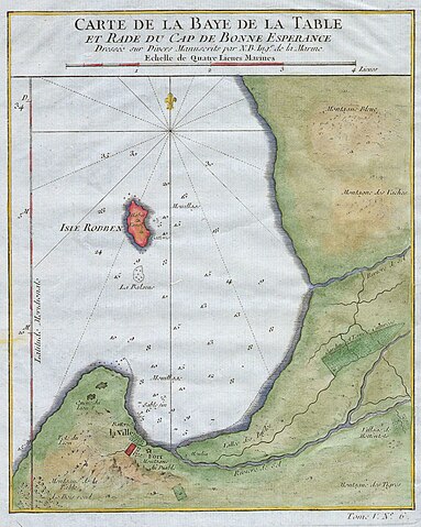
| Jacques-Nicolas Bellin: Carte de la Baye de la Table et Rade eu Cap de Bonne Experance.
( |
||||||||||||||||||||
|---|---|---|---|---|---|---|---|---|---|---|---|---|---|---|---|---|---|---|---|---|
| Artist |
|
|||||||||||||||||||
| Title |
Carte de la Baye de la Table et Rade eu Cap de Bonne Experance. |
|||||||||||||||||||
| Description |
English: This hand colored map is a c. 1763 map of the Cape of Good Hope and Cape Town, South Africa. Attributed to French cartographer Jacques-Nicholas Bellin, this map was issued for the French edition of Provost’s Histoire des Voyages…. Beautifully rendered mountains and villages show the area in considerable detail. Shows the “Village of the Hottentots”, Blue Mountain, Cow Mountain, Table Mountain, The City of Cape Town itself, Tigerbergen, and many other features. Some oceanic depths are indicated. Of interest is also the Isle of Robben, located centrally on the map. Long a place of exile and punishment, this island prison had a reputation for brutality and cruelty. Today a museum honors the site of so much suffering. |
|||||||||||||||||||
| Date | 1763 | |||||||||||||||||||
| Dimensions | height: 7 in (17.7 cm); width: 9 in (22.8 cm) | |||||||||||||||||||
| Accession number |
Geographicus link: GoodHope2-bellin-1763 |
|||||||||||||||||||
| Source/Photographer |
|
|||||||||||||||||||
| Permission (Reusing this file) |
|
|||||||||||||||||||
File history
Click on a date/time to view the file as it appeared at that time.
| Date/Time | Thumbnail | Dimensions | User | Comment | |
|---|---|---|---|---|---|
| current | 12:36, 12 March 2011 | | 2,077 × 2,600 (1,006 KB) | BotMultichill (talk | contribs) | {{subst:User:Multichill/Geographicus |link=http://www.geographicus.com/P/AntiqueMap/GoodHope2-bellin-1763 |product_name=1763 Bellin Map of Cape Town ( Cape of Good Hope ) South Africa |map_title=Carte de la Baye de la Table et Rade eu Cap de Bonne Experan |
You cannot overwrite this file.
File usage on Commons
The following 3 pages use this file:
_South_Africa_-_Geographicus_-_GoodHope2-bellin-1763.jpg)
_South_Africa_-_Geographicus_-_GoodHope2-bellin-1763.jpg&redirect=no)
File usage on other wikis
The following other wikis use this file:
_South_Africa_-_Geographicus_-_GoodHope2-bellin-1763.jpg&oldid=793277415)