File:1758 Bellin Map of St. Lucia ( St. Lucie ), in the West Indies - Geographicus - StLucie-bellin-1758.jpg
Jump to navigation
Jump to search

Size of this preview: 800 × 530 pixels. Other resolutions: 320 × 212 pixels | 640 × 424 pixels | 1,024 × 679 pixels | 1,280 × 849 pixels | 3,000 × 1,989 pixels.
Original file (3,000 × 1,989 pixels, file size: 1.74 MB, MIME type: image/jpeg)
Captions
Captions
Add a one-line explanation of what this file represents
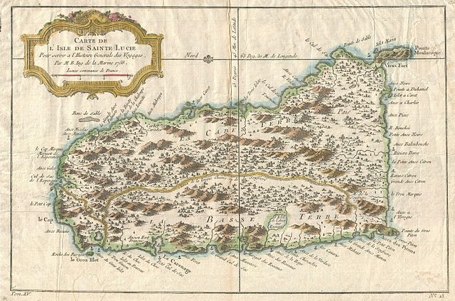
| Jacques-Nicolas Bellin: Carte de L’Isle de Sainte Lucie.
( |
||||||||||||||||||||
|---|---|---|---|---|---|---|---|---|---|---|---|---|---|---|---|---|---|---|---|---|
| Artist |
|
|||||||||||||||||||
| Title |
Carte de L’Isle de Sainte Lucie. |
|||||||||||||||||||
| Description |
English: This beautiful little map depicts the Caribbean island of St. Lucia or St. Lucie. Shows the island in some detail showing the island's single road as well as various towns and anchorages. Topography drawn in profile. Some offshore features and undersea dangers such as the Banc de Sable are noted. Decorative baroque title cartouche in the upper left quadrant. This map was published in 1758 for Provost's L`Histoire Generale des Voyages . |
|||||||||||||||||||
| Date | 1758 (dated) | |||||||||||||||||||
| Dimensions | height: 9 in (22.8 cm); width: 12.5 in (31.7 cm) | |||||||||||||||||||
| Accession number |
Geographicus link: StLucie-bellin-1758 |
|||||||||||||||||||
| Source/Photographer |
Provost, A., L`Histoire Generale des Voyages, 1758.
|
|||||||||||||||||||
| Permission (Reusing this file) |
|
|||||||||||||||||||
File history
Click on a date/time to view the file as it appeared at that time.
| Date/Time | Thumbnail | Dimensions | User | Comment | |
|---|---|---|---|---|---|
| current | 17:21, 24 March 2011 | | 3,000 × 1,989 (1.74 MB) | BotMultichillT (talk | contribs) | {{subst:User:Multichill/Geographicus |link=http://www.geographicus.com/P/AntiqueMap/StLucie-bellin-1758 |product_name=1758 Bellin Map of St. Lucia ( St. Lucie ), in the West Indies |map_title=Carte de L’Isle de Sainte Lucie. |description=This beautifu |
You cannot overwrite this file.
File usage on Commons
The following page uses this file:
,_in_the_West_Indies_-_Geographicus_-_StLucie-bellin-1758.jpg)
File usage on other wikis
The following other wikis use this file:
- Usage on fr.wikipedia.org
- Usage on hu.wikipedia.org
,_in_the_West_Indies_-_Geographicus_-_StLucie-bellin-1758.jpg&oldid=744704936)