File:1754 Bellin Map of Mexico City ^ Environs - Geographicus - MexicoCity2-bellin-1754.jpg
Jump to navigation
Jump to search

Size of this preview: 501 × 600 pixels. Other resolutions: 200 × 240 pixels | 401 × 480 pixels | 641 × 768 pixels | 855 × 1,024 pixels | 2,095 × 2,508 pixels.
Original file (2,095 × 2,508 pixels, file size: 1.03 MB, MIME type: image/jpeg)
Captions
Captions
Add a one-line explanation of what this file represents
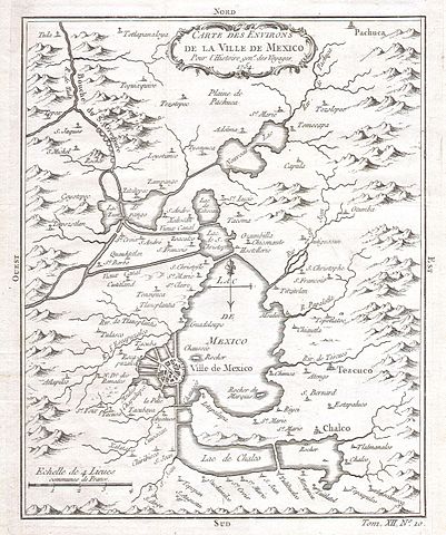
| Jacques-Nicolas Bellin: Carte des Environs de La Ville de Mexico pour l’Histoire gen. des Voyages. 1754.
( |
||||||||||||||||||||
|---|---|---|---|---|---|---|---|---|---|---|---|---|---|---|---|---|---|---|---|---|
| Artist |
|
|||||||||||||||||||
| Title |
Carte des Environs de La Ville de Mexico pour l’Histoire gen. des Voyages. 1754. |
|||||||||||||||||||
| Description |
English: This beautiful little map of Mexico City was produced by the French Cartographer Jacques-Nicolas Bellin in 1754.
|
|||||||||||||||||||
| Date | 1754 | |||||||||||||||||||
| Dimensions | height: 6.5 in (16.5 cm); width: 8 in (20.3 cm) | |||||||||||||||||||
| Accession number |
Geographicus link: MexicoCity2-bellin-1754 |
|||||||||||||||||||
| Source/Photographer |
|
|||||||||||||||||||
| Permission (Reusing this file) |
|
|||||||||||||||||||
File history
Click on a date/time to view the file as it appeared at that time.
| Date/Time | Thumbnail | Dimensions | User | Comment | |
|---|---|---|---|---|---|
| current | 23:50, 24 March 2011 | | 2,095 × 2,508 (1.03 MB) | BotMultichillT (talk | contribs) | {{subst:User:Multichill/Geographicus |link=http://www.geographicus.com/P/AntiqueMap/MexicoCity2-bellin-1754 |product_name=1754 Bellin Map of Mexico City & Environs |map_title=Carte des Environs de La Ville de Mexico pour l’Histoire gen. des Voyages. 175 |
You cannot overwrite this file.
File usage on Commons
The following page uses this file: