File:1751 60000 t autour Paris Tables 1756.jpg
Jump to navigation
Jump to search

Size of this preview: 601 × 599 pixels. Other resolutions: 241 × 240 pixels | 482 × 480 pixels | 918 × 915 pixels.
Original file (918 × 915 pixels, file size: 373 KB, MIME type: image/jpeg)
Captions
Captions
Add a one-line explanation of what this file represents
Summary[edit]
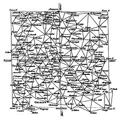
| Description |
Français : Carte triangulée de 60 000 toises autour de Paris. |
| Date | av. 1751 |
| Source | BnF, Gallica, Cassini de Thury (1714-1784), Explication de la table pour trouver les distances réciproques de différents lieux, accès en ligne. |
| Author | Cassini de Thury |
Licensing[edit]
|
This work is in the public domain in its country of origin and other countries and areas where the copyright term is the author's life plus 100 years or fewer. | |
| This file has been identified as being free of known restrictions under copyright law, including all related and neighboring rights. | |
File history
Click on a date/time to view the file as it appeared at that time.
| Date/Time | Thumbnail | Dimensions | User | Comment | |
|---|---|---|---|---|---|
| current | 16:10, 16 June 2015 | | 918 × 915 (373 KB) | Kergeo (talk | contribs) | User created page with UploadWizard |
You cannot overwrite this file.
File usage on Commons
The following page uses this file:
File usage on other wikis
The following other wikis use this file:
- Usage on ca.wikipedia.org
- Usage on fr.wikipedia.org