File:1750 Homann Heirs Map of Poland - Geographicus - Poloniae-homannheirs-1750.jpg
Jump to navigation
Jump to search
Size of this preview: 675 × 599 pixels. Other resolutions: 270 × 240 pixels | 541 × 480 pixels | 865 × 768 pixels | 1,153 × 1,024 pixels | 2,306 × 2,048 pixels | 4,000 × 3,552 pixels.
Original file (4,000 × 3,552 pixels, file size: 3.07 MB, MIME type: image/jpeg)
Captions
Captions
Add a one-line explanation of what this file represents
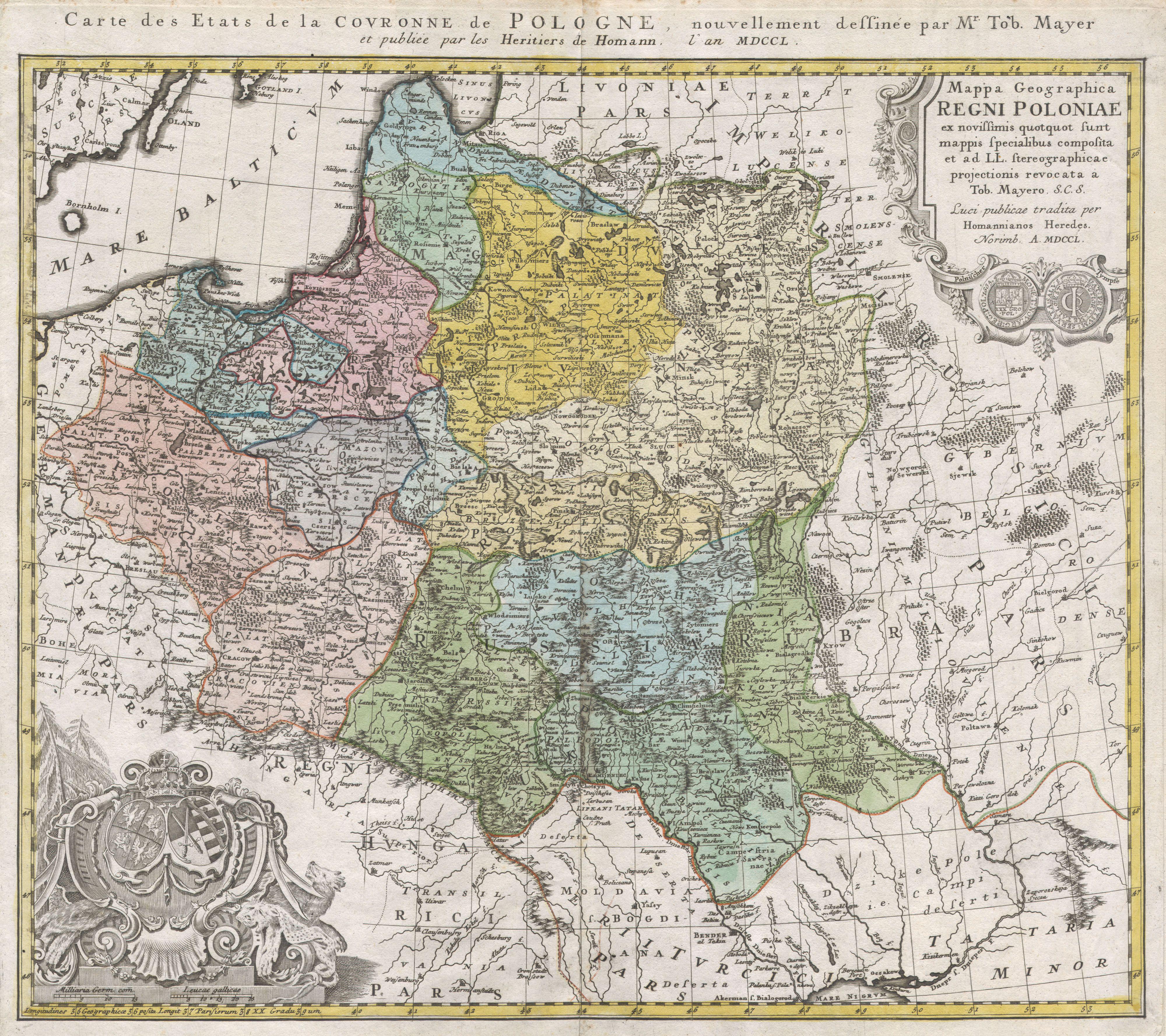
| Mappa Geographica Regni Poloniae ex novissimis quotquot sunt mappis specialibus composita et al L.L. Stereographicae projectionis revocata a Tob. Mayero. | ||||||
|---|---|---|---|---|---|---|
| Artist | ||||||
| Title |
Mappa Geographica Regni Poloniae ex novissimis quotquot sunt mappis specialibus composita et al L.L. Stereographicae projectionis revocata a Tob. Mayero. |
|||||
| Description |
English: This is one of the Homann Heirs finest and most appealing maps of Poland. Depicts the Poland extending north as far as Latvia, Lithuania, and the Lithuanian Sea and south as far as the Carpathian Mountains, Moldova, and Transylvania. Features two elaborate decorative cartouches, one in the upper right quadrant decorated with a Polish coin, and another in the lower left quadrant bearing the Polish armorial emblems. Additional French title outside top border: Carte des Etats de la Couronne de Pologne, nouvellement dessinee par Mr. Tob. Mayer. This map was drawn by Tob. Mayer for inclusion the 1752 Homann Heirs Maior Atlas Scholasticus ex Triginta Sex Generalibus et Specialibus…. Most early Homann atlases were “made to order” or compiled of individual maps at the request of the buyer. However, this rare atlas, composed of 37 maps and charts, was issued as a “suggested collection” of essential Homann Heirs maps. A fine copy of an important map. |
|||||
| Date | 1750 | |||||
| Dimensions | height: 18 in (45.7 cm); width: 21 in (53.3 cm) | |||||
| Accession number |
Geographicus link: Poloniae-homannheirs-1750 |
|||||
| Source/Photographer |
|
|||||
| Permission (Reusing this file) |
|
|||||
File history
Click on a date/time to view the file as it appeared at that time.
| Date/Time | Thumbnail | Dimensions | User | Comment | |
|---|---|---|---|---|---|
| current | 11:05, 24 March 2011 | | 4,000 × 3,552 (3.07 MB) | BotMultichillT (talk | contribs) | {{subst:User:Multichill/Geographicus |link=http://www.geographicus.com/P/AntiqueMap/Poloniae-homannheirs-1750 |product_name=1750 Homann Heirs Map of Poland |map_title=Mappa Geographica Regni Poloniae ex novissimis quotquot sunt mappis specialibus composit |
You cannot overwrite this file.
File usage on Commons
The following page uses this file:
File usage on other wikis
The following other wikis use this file:
- Usage on lt.wikibooks.org