File:1741 Homann Heirs Map of Ancient Greece ^ the Eastern Mediterranean - Geographicus - Graecia-homannheirs-1741.jpg
Jump to navigation
Jump to search

Size of this preview: 698 × 600 pixels. Other resolutions: 279 × 240 pixels | 559 × 480 pixels | 894 × 768 pixels | 1,192 × 1,024 pixels | 2,384 × 2,048 pixels | 4,000 × 3,436 pixels.
Original file (4,000 × 3,436 pixels, file size: 2.85 MB, MIME type: image/jpeg)
Captions
Captions
Add a one-line explanation of what this file represents
| Artist | ||||||
| Title |
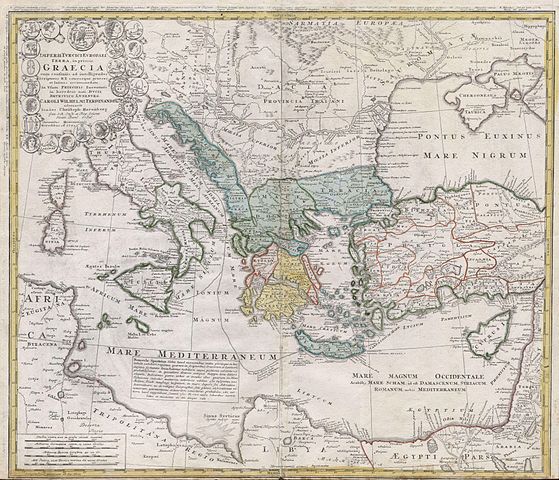
Imperii Turcici Europaei Terra, in primis Graecia cum consiniis ad intelligendos Scriptores N.T. ceterospue graecos et latinos accomodata, In Usum Principis Iuventutis in heredem nati, Ducis Brunsuico - Luneburgi Caroli Wilhelmi Ferdinandi ad ornavit Ioannes Christoph Harenberg. Gen. Sch Insp. et Reg Scient, Societ Berol. Sodal. Curantibus Homannianis Heredibus. A. 1741 cu. Arivil. S. C.M. |
|||||
| Description |
English: This is one of the Homann Heirs finest and most appealing maps of the ancient Greek World. Map centers on Greece but includes the entirety of the eastern Mediterranean and North Africa. Also includes the Black Sea as far as the Crimea and the sea of Azov. Extends north as far as Sarmatia and Pannonia. Includes Italy, Sicily, Corsica and Sardinia. Upper left quadrant features a decorative title cartouche adorned with the rectos and versos of 12 ancient Greek coins with explanatory numbered references outside the top border of the map. Show the important Greek provinces and colonies through the Mediterranean, especially in modern day turkey and in the Italian peninsula. Includes nautical military and trade routes. This map was drawn by Joanes Christoph Harenberg for inclusion the 1752 Homann Heirs Maior Atlas Scholasticus ex Triginta Sex Generalibus et Specialibus…. Most early Homann atlases were “made to order” or compiled of individual maps at the request of the buyer. However, this rare atlas, composed of 37 maps and charts, was issued as a “suggested collection” of essential Homann Heirs maps. A fine copy of an important map. |
|||||
| Date | 1741 | |||||
| Dimensions | height: 20 in (50.8 cm); width: 24 in (60.9 cm) | |||||
| Accession number |
Geographicus link: Graecia-homannheirs-1741 |
|||||
| Source/Photographer |
|
|||||
| Permission (Reusing this file) |
|
|||||
File history
Click on a date/time to view the file as it appeared at that time.
| Date/Time | Thumbnail | Dimensions | User | Comment | |
|---|---|---|---|---|---|
| current | 14:52, 24 March 2011 | | 4,000 × 3,436 (2.85 MB) | BotMultichillT (talk | contribs) | {{subst:User:Multichill/Geographicus |link=http://www.geographicus.com/P/AntiqueMap/Graecia-homannheirs-1741 |product_name=1741 Homann Heirs Map of Ancient Greece & the Eastern Mediterranean |map_title=Imperii Turcici Europaei Terra, in primis Graecia cum |
You cannot overwrite this file.
File usage on Commons
The following page uses this file:
File usage on other wikis
The following other wikis use this file:
- Usage on la.wikipedia.org