File:1730 Homann Map of Spain and Portugal - Geographicus - Hispania-homann-1730.jpg
Jump to navigation
Jump to search

Size of this preview: 712 × 600 pixels. Other resolutions: 285 × 240 pixels | 570 × 480 pixels | 912 × 768 pixels | 1,216 × 1,024 pixels | 2,431 × 2,048 pixels | 5,000 × 4,212 pixels.
Original file (5,000 × 4,212 pixels, file size: 7.63 MB, MIME type: image/jpeg)
Captions
Captions
Add a one-line explanation of what this file represents
| Artist |
|
|||||||||||||||||||||||
| Title |
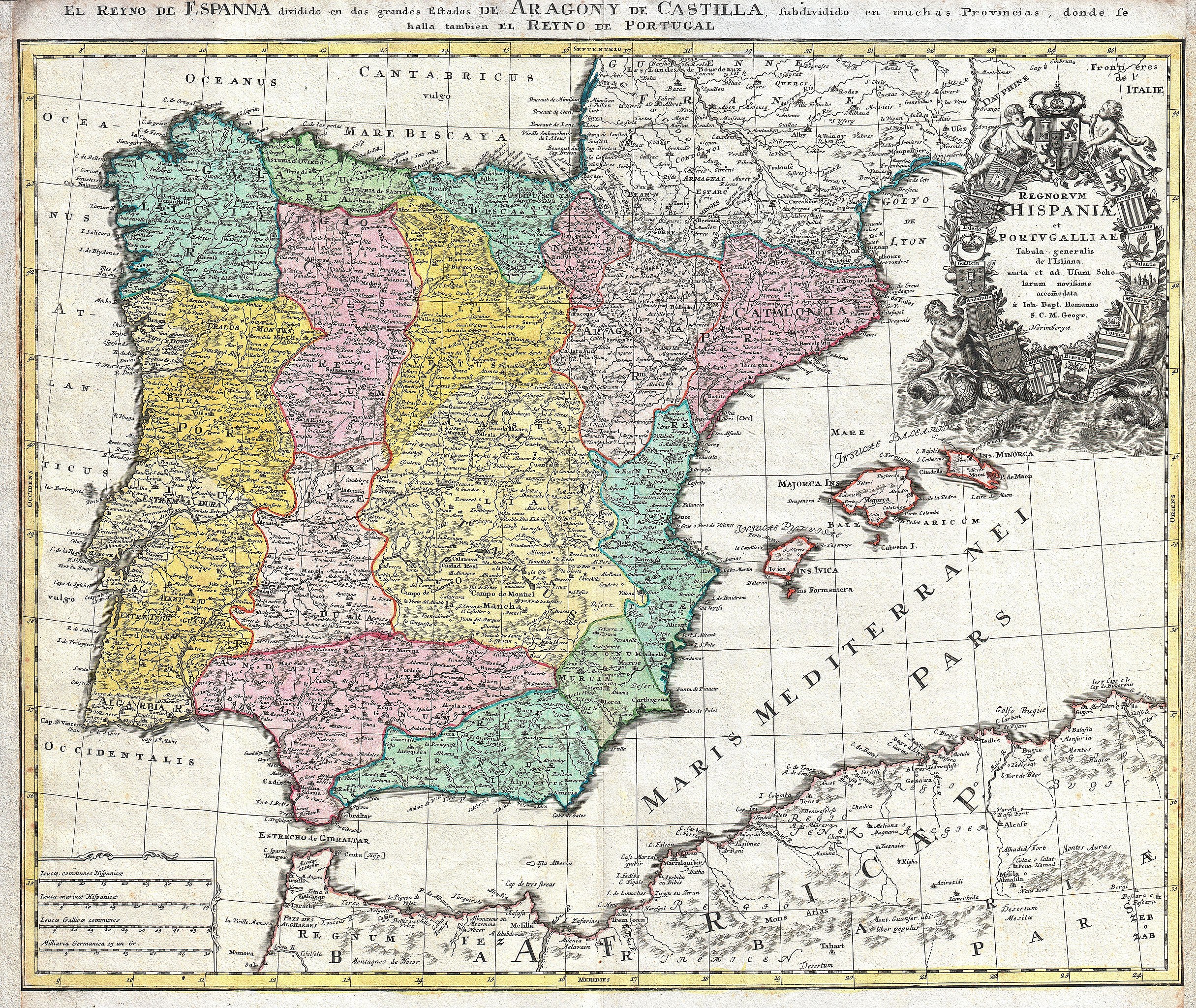
Regnorum Hispaniae et Portugalliae Tabula generalis de l'Isliana aucta et ad Usum Scholarum novissime accomodata á Ioh. Bapt. Homanno S.C.M. Geogr. Norimbergae. - El Reyno de Espanna dividido en dos grandes Estados de Argon Y de Castilla, subdividido en muchas Provincias, donde le halla tambien El Reyno de Portugal. |
|||||||||||||||||||||||
| Description |
English: A beautifully detailed c. 1730 J. B. Homann map of Spain and Portugal. Depicts the Iberian peninsula in considerable detail including the Balearic Islands of Majorca, Minorca and Ibiza. Also covers parts of France and northern Africa. The map notes fortified cities, villages, roads, bridges, forests, castles and topography. Elaborate title cartouche in the upper right quadrant features two mermen supporting a wreath and 15 armorial crests, 14 crests for the various regions of Spain in addition to one more depicting the Spanish royal arms. Map scales in lower left quadrant. Alternative title in Spanish in top margin, El Reyno de Espanna dividido en dos grandes Estados de Argon Y de Castilla, subdividido en muchas Provincias, donde le halla tambien El Reyno de Portugal. This map was drawn in Nuremberg by J. B. Homann and included in the Homann Heirs Maior Atlas Scholasticus ex Triginta Sex Generalibus et Specialibus…. . |
|||||||||||||||||||||||
| Date | circa 1730(undated) | |||||||||||||||||||||||
| Dimensions | height: 19.5 in (49.5 cm); width: 23 in (58.4 cm) | |||||||||||||||||||||||
| Accession number |
Geographicus link: Hispania-homann-1730 |
|||||||||||||||||||||||
| Source/Photographer |
Major Atlas Scholasticus Ex Triginta sex Generalibus et Specialibus Mappis Homannianis..., c. 1750. / Also issued in Homann's Grosser Atlas
|
|||||||||||||||||||||||
| Permission (Reusing this file) |
|
|||||||||||||||||||||||
.jpg)
File history
Click on a date/time to view the file as it appeared at that time.
| Date/Time | Thumbnail | Dimensions | User | Comment | |
|---|---|---|---|---|---|
| current | 21:25, 16 March 2011 | | 5,000 × 4,212 (7.63 MB) | BotMultichill (talk | contribs) | {{subst:User:Multichill/Geographicus |link=http://www.geographicus.com/P/AntiqueMap/Hispania-homann-1730 |product_name=1730 Homann Map of Spain and Portugal |map_title=Regnorum Hispaniae et Portugalliae Tabula generalis de l'Isliana aucta et ad Usum Schol |
You cannot overwrite this file.
File usage on Commons
The following 2 pages use this file:
.jpg)
File usage on other wikis
The following other wikis use this file:
- Usage on cs.wikipedia.org
- Usage on de.wikipedia.org