File:12E Hurricane Kristy 2006.jpg
Jump to navigation
Jump to search

Size of this preview: 571 × 600 pixels. Other resolutions: 228 × 240 pixels | 457 × 480 pixels | 731 × 768 pixels | 975 × 1,024 pixels | 1,949 × 2,048 pixels | 4,419 × 4,643 pixels.
Original file (4,419 × 4,643 pixels, file size: 12.47 MB, MIME type: image/jpeg)
Captions
Captions
Add a one-line explanation of what this file represents
Summary[edit]
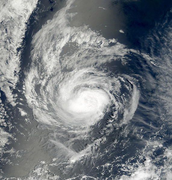
| Description | This image of Hurricane Kristy was captured by the MODIS instrument on NASA's Terra satellite at 1843 UTC on August 31, 2006 when it was located in the eastern Pacific Ocean. At the time, maximum sustained winds were 75 mph and the minimum pressure was approximately 987 mb. | ||||||
| Date | |||||||
| Source | http://www.nrlmry.navy.mil/tc_pages/tc_home.html | ||||||
| Author | Naval Research Laboratory | ||||||
| Permission (Reusing this file) |
|
||||||

File history
Click on a date/time to view the file as it appeared at that time.
| Date/Time | Thumbnail | Dimensions | User | Comment | |
|---|---|---|---|---|---|
| current | 21:17, 5 March 2013 | | 4,419 × 4,643 (12.47 MB) | Supportstorm (talk | contribs) | Color |
| 19:45, 5 September 2006 |  | 3,220 × 3,220 (1.58 MB) | Good kitty (talk | contribs) | == Summary == {{Information |Description=This image of Hurricane Kristy was captured at 1843 UTC on August 31, 2006 when it was located in the eastern Pacific Ocean. At the time, maximum sustained winds were 75 mph and the minimum pressure was approximate |
You cannot overwrite this file.
File usage on Commons
There are no pages that use this file.
File usage on other wikis
The following other wikis use this file:
- Usage on de.wikipedia.org
- Usage on en.wikipedia.org
- Usage on es.wikipedia.org
- Usage on pt.wikipedia.org
- Usage on simple.wikipedia.org
- Usage on zh.wikipedia.org