File:1263 Morze Śródziemne.svg
Jump to navigation
Jump to search

Size of this PNG preview of this SVG file: 800 × 367 pixels. Other resolutions: 320 × 147 pixels | 640 × 293 pixels | 1,024 × 469 pixels | 1,280 × 587 pixels | 2,560 × 1,173 pixels | 925 × 424 pixels.
Original file (SVG file, nominally 925 × 424 pixels, file size: 703 KB)
Captions
Captions
Add a one-line explanation of what this file represents
Summary[edit]
| Description |
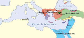
Čeština: Situace mezi Byzantskou říší a jejími převážně východními sousedy (muslimy) v roce 1263 (polské popisky)
English: Map showing 13th-century history — in 1263 in the Mediterranean region of Europe, Asia, and Africa.
|
| Date | (UTC) |
| Source | |
| Author |
|
| Other versions |
[]
|


| This is a retouched picture, which means that it has been digitally altered from its original version. Modifications: Polish captions. The original can be viewed here: 1263 Mediterranean Sea.svg:
|
Licensing[edit]
I, the copyright holder of this work, hereby publish it under the following license:
| |
This work has been released into the public domain by its author, Example, at the [[::|English Wikipedia]] project. This applies worldwide. In case this is not legally possible: |
Original upload log[edit]
This image is a derivative work of the following images:
- File:1263_Mediterranean_Sea.svg licensed with PD-user-w
- 2011-12-10T17:08:57Z Hoodinski 925x424 (721052 Bytes) == {{int:filedesc}} == {{Information |Description={{en|Middle East c. 1263. KEY: *Dark Green: Ottoman domain by 1300's, dotted line indicates conquests up to 1326 *Purple: Byzantine Empire (successor of Nicaean Empire) *Light
Uploaded with derivativeFX
File history
Click on a date/time to view the file as it appeared at that time.
| Date/Time | Thumbnail | Dimensions | User | Comment | |
|---|---|---|---|---|---|
| current | 17:12, 10 December 2011 | | 925 × 424 (703 KB) | Hoodinski (talk | contribs) | == {{int:filedesc}} == {{Information |Description= |Source=*File:1263_Mediterranean_Sea.svg |Date=2011-12-10 17:12 (UTC) |Author=*File:1263_Mediterranean_Sea.svg: *1263_Mediterranean_Sea.PNG: Original uploa |
You cannot overwrite this file.
File usage on Commons
The following 11 pages use this file:
- File:1263 Mediterranean Sea-ar.svg
- File:1263 Mediterranean Sea-ca.svg
- File:1263 Mediterranean Sea-es.svg
- File:1263 Mediterranean Sea-hu.svg
- File:1263 Mediterranean Sea-hy.png
- File:1263 Mediterranean Sea-pt.svg
- File:1263 Mediterranean Sea-zh.svg
- File:1263 Mediterranean Sea.svg
- File:1263 Morze Śródziemne.svg
- File:Bütsants1263.PNG
- Template:Other versions/1263 Mediterranean Sea
File usage on other wikis
The following other wikis use this file:
- Usage on pl.wikipedia.org
Categories:
- Maps showing 13th-century history
- 1263
- Maps of the history of the Mediterranean
- Maps of the Ottoman Empire in the 13th century
- Maps of Palestine in 13th century
- Maps of Bahri dynasty
- Maps of the Byzantine empire in the 13th century
- Maps of the Sultanate of Rum
- Armenian Kingdom of Cilicia
- Despotate of Epirus
- Egypt in the 1260s
- Asia in the 13th century
- Europe in the 1260s
- Egypt in the 13th century
- Palestine in the 13th century
- Polish-language SVG maps showing history