File:1030 yılı Gazne Devleti haritası.png
Jump to navigation
Jump to search
No higher resolution available.
1030_yılı_Gazne_Devleti_haritası.png (600 × 520 pixels, file size: 83 KB, MIME type: image/png)
Captions
Captions
Add a one-line explanation of what this file represents
| Description |
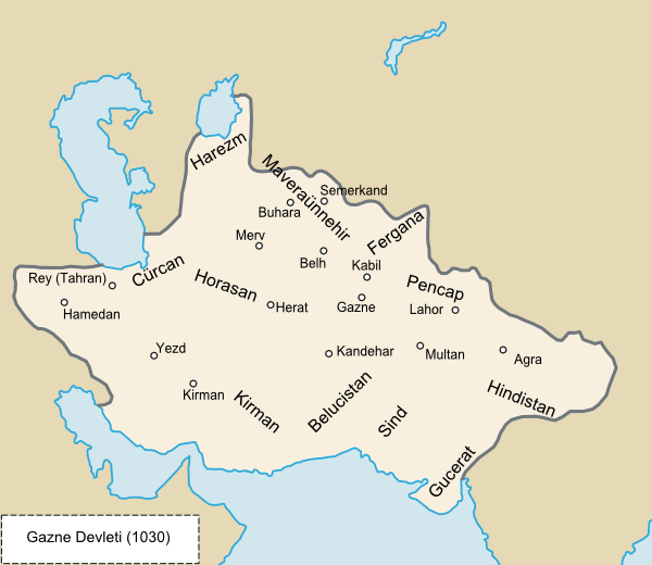
Türkçe: 1030 yılı Gazne Devleti haritası
English: Ghaznavid Empire in 1030 |
| Date | 10 September 2009 (upload date) |
| Source | Own work, I've used the map in "Büyük Türkiye Tarihi" which was written by Yılmaz Öztuna. And minor boundary changes were made from "Gazneliler Devleti Tarihi" which was written by Erdoğan Merçil. |
| Author | Gökçe Yörük |
Licensing[edit]
| This work has been released into the public domain by its author, Lord Leatherface at English Wikipedia. This applies worldwide. In some countries this may not be legally possible; if so: Lord Leatherface grants anyone the right to use this work for any purpose, without any conditions, unless such conditions are required by law. |
File history
Click on a date/time to view the file as it appeared at that time.
| Date/Time | Thumbnail | Dimensions | User | Comment | |
|---|---|---|---|---|---|
| current | 19:53, 10 September 2009 | | 600 × 520 (83 KB) | Lord Leatherface (talk | contribs) | {{Information |Description= {{tr|1030 yılı Gazne Devleti haritası}} {{en|en:Ghaznavid Empire}} |Source=Own work, I've used the map in Büyük Türkiye Tarihi which was written by Yılmaz Öztuna. |Date=10.09.2009 |Author=[[:t |
You cannot overwrite this file.
File usage on Commons
There are no pages that use this file.
File usage on other wikis
The following other wikis use this file:
- Usage on tr.wikipedia.org