File:101209-A-6479G-004 (5247409043).jpg
From Wikimedia Commons, the free media repository
Jump to navigation
Jump to search

Size of this preview: 800 × 531 pixels. Other resolutions: 320 × 213 pixels | 640 × 425 pixels | 1,024 × 680 pixels | 1,280 × 850 pixels | 2,560 × 1,700 pixels | 4,288 × 2,848 pixels.
Original file (4,288 × 2,848 pixels, file size: 4.79 MB, MIME type: image/jpeg)
File information
Structured data
Captions
Captions
Add a one-line explanation of what this file represents
Summary[edit]
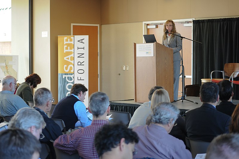
| Description101209-A-6479G-004 (5247409043).jpg | WEST SACRAMENTO, Calif. (Dec. 9, 2010) – U.S. Army Corps of Engineers Sacramento District’s Linda Finley discusses the Corps’ Central Valley Integrated Flood Management Study at the California Department of Water Resources’ Valleywide Forum here Dec. 9, a public meeting to detail progress on California’s Central Valley Flood Protection Plan. Both California’s and the Corps’ plans aim to develop a sustainable flood risk reduction system in California’s Central Valley. |
| Date | |
| Source | 101209-A-6479G-004.jpg |
| Author | U.S. Army Corps of Engineers Sacramento District |
| Camera location | 38° 34′ 52.3″ N, 121° 31′ 28.52″ W | View this and other nearby images on: OpenStreetMap |
|---|
Licensing[edit]
| Public domainPublic domainfalsefalse |
This image or file is a work of a U.S. Army Corps of Engineers soldier or employee, taken or made as part of that person's official duties. As a work of the U.S. federal government, the image is in the public domain.
English | italiano | Nederlands | پښتو | русский | sicilianu | slovenščina | Türkçe | українська | +/− |
| This image was originally posted to Flickr by USACE-Sacramento District at https://flickr.com/photos/52057813@N07/5247409043. It was reviewed on 12 October 2016 by FlickreviewR and was confirmed to be licensed under the terms of the United States Government Work. |
12 October 2016
File history
Click on a date/time to view the file as it appeared at that time.
| Date/Time | Thumbnail | Dimensions | User | Comment | |
|---|---|---|---|---|---|
| current | 06:50, 12 October 2016 |  | 4,288 × 2,848 (4.79 MB) | Vanished Account Byeznhpyxeuztibuo (talk | contribs) | Transferred from Flickr via Flickr2Commons |
You cannot overwrite this file.
File usage on Commons
There are no pages that use this file.
Metadata
This file contains additional information such as Exif metadata which may have been added by the digital camera, scanner, or software program used to create or digitize it. If the file has been modified from its original state, some details such as the timestamp may not fully reflect those of the original file. The timestamp is only as accurate as the clock in the camera, and it may be completely wrong.
| Image title |
|
|---|---|
| Camera manufacturer | NIKON CORPORATION |
| Camera model | NIKON D300 |
| Author | Chris Gray-Garcia |
| Exposure time | 1/25 sec (0.04) |
| F-number | f/8 |
| ISO speed rating | 800 |
| Date and time of data generation | 14:56, 9 December 2010 |
| Lens focal length | 55 mm |
| Horizontal resolution | 240 dpi |
| Vertical resolution | 240 dpi |
| Software used | Ver.1.03 |
| File change date and time | 17:09, 9 December 2010 |
| Exposure Program | Manual |
| Exif version | 2.21 |
| Date and time of digitizing | 14:56, 9 December 2010 |
| APEX shutter speed | 4.643856 |
| APEX aperture | 6 |
| APEX exposure bias | 0 |
| Maximum land aperture | 4 APEX (f/4) |
| Subject distance | 12.6 meters |
| Metering mode | Pattern |
| Light source | Unknown |
| Flash | Flash did not fire |
| DateTimeOriginal subseconds | 86 |
| DateTimeDigitized subseconds | 86 |
| Sensing method | One-chip color area sensor |
| File source | Digital still camera |
| Scene type | A directly photographed image |
| Custom image processing | Normal process |
| Exposure mode | Manual exposure |
| White balance | Auto white balance |
| Digital zoom ratio | 1 |
| Focal length in 35 mm film | 82 mm |
| Scene capture type | Standard |
| Scene control | Low gain up |
| Contrast | Normal |
| Saturation | Normal |
| Sharpness | Normal |
| Subject distance range | Unknown |
| Width | 4,288 px |
| Height | 2,848 px |
| Image width | 4,288 px |
| Image height | 2,848 px |
| Serial number of camera | 3170642 |
| Lens used | 55.0-200.0 mm f/4.0-5.6 |
| Date metadata was last modified | 00:41, 10 December 2010 |
| Copyright status | Copyrighted |
| Keywords |
|
| Sublocation of city shown | West Sacramento, Calif. |
| IIM version | 2 |
Structured data
Items portrayed in this file
depicts
9 December 2010
38°34'52.302"N, 121°31'28.520"W
0.04 second
55 millimetre
800
image/jpeg
9a7b43cf430a0083ed82f45fda1e439205be590c
5,021,110 byte
2,848 pixel
4,288 pixel
Hidden categories:
