File:06-WFF Map and Vicinity.png
Jump to navigation
Jump to search
Size of this preview: 800 × 489 pixels. Other resolutions: 320 × 196 pixels | 640 × 392 pixels | 904 × 553 pixels.
Original file (904 × 553 pixels, file size: 237 KB, MIME type: image/png)
Captions
Captions
Add a one-line explanation of what this file represents
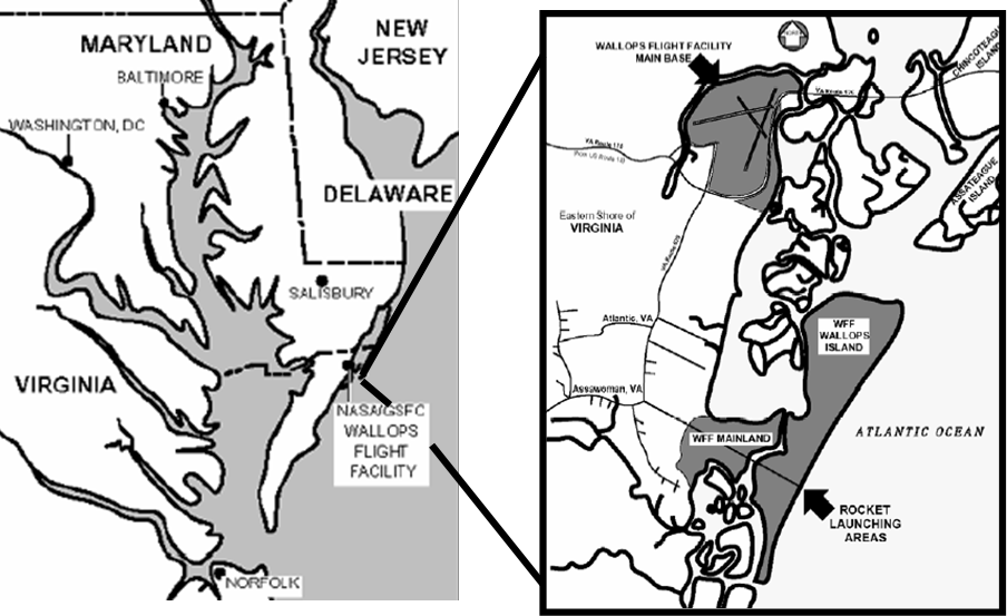
| Description | NASA Wallops Flight Facility | |||||
| Date | ||||||
| Source | Wallops Flight Facility Range User’s Handbook, Version G, Effective December 1, 2003. 840-HDBK-0001G. Page 3. http://www.wff.nasa.gov/multimedia/docs/wffruh.pdf | |||||
| Author | NASA | |||||
| Permission (Reusing this file) |
|

File history
Click on a date/time to view the file as it appeared at that time.
| Date/Time | Thumbnail | Dimensions | User | Comment | |
|---|---|---|---|---|---|
| current | 20:19, 20 April 2006 | | 904 × 553 (237 KB) | VillhardV (talk | contribs) | {{Information| |Description=NASA Wallops Flight FacilityBeach View |Source=NASA Wallops Flight Facility |Date=20 Apr 2006 |Author=NASA |Permission=Public Domain }} |
You cannot overwrite this file.
File usage on Commons
The following page uses this file:
File usage on other wikis
The following other wikis use this file:
- Usage on cs.wikipedia.org
- Usage on de.wikipedia.org
- Usage on en.wikipedia.org
- Usage on fa.wikipedia.org
- Usage on he.wikipedia.org
- Usage on ja.wikipedia.org
- Usage on lb.wikipedia.org
- Usage on pl.wikipedia.org
- Usage on pt.wikipedia.org
- Usage on ru.wikipedia.org