File:04 2022 Roma (Arco di Trionfo di Tito- Bassorilievi) FO228683 bis Photo by Paolo Villa.jpg
Jump to navigation
Jump to search

Size of this preview: 800 × 589 pixels. Other resolutions: 320 × 236 pixels | 640 × 471 pixels | 1,024 × 754 pixels | 1,280 × 942 pixels | 2,560 × 1,884 pixels | 7,912 × 5,824 pixels.
Original file (7,912 × 5,824 pixels, file size: 5.16 MB, MIME type: image/jpeg)
Captions
Captions
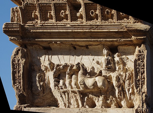
Detail from the Arch of Titus showing Titus as triumphator - Triumph in Rome, barrel vault, egg-and-dart, rosette, candelabra, tunic, entablature, bas-relief, high relief, panneggio bagnato
Summary
Object
| Description |
Italiano: 04 2022 Roma (Arco di Trionfo di Tito- Bassorilievi) FO228683 bis - Rilievo dall'Arco di Tito, raffigurante la quadriga (carro trainato da 4 cavalli) del vincitore, in mezzo ai soldati con pilum (lance o aste), dietro a Tito sul carro la Vittoria alata, sotto un nudo eroico muscoloso (bello ideale) e panneggio bagnato - Volta a botte cassettonata con ovoli e dardi e rosette, ordine dorico agli stipiti con candelabre, alto e bassorilievo per ampliare la profondità, panneggio, tuniche.
العربية: قوس تيتوس: الداخلية الشمالية ، الإغاثة من انتصار تيتوس
Čeština: Titův oblouk: Titův triumfální reliéf
Deutsch: Titusbogen: Triumphatorrelief
English: Detail from the Arch of Titus showing Titus as triumphator - Triumph in Rome, barrel vault, egg-and-dart, rosette, candelabra, tunic, entablature, bas-relief, high relief, panneggio bagnato, Roman triumph, Titus, quadriga, Nike, horses, pilum, victory, Victoria
Українська: Фрагмент арки Тита , Тит Флавій Веспасіан на квадризі під час тріумфу
中文:提图斯凯旋门:提图斯作为胜利者的北内浮雕 |
Photograph
| Description |
English: Detail from the Arch of Titus showing Titus as triumphator - Triumph in Rome, barrel vault, egg-and-dart, rosette, candelabra, tunic, entablature, bas-relief, high relief, panneggio bagnato |
| Date | |
| Source | Own work |
| Author | Paolo Villa |
| Other versions |
|
_FO228683_Photo_by_Paolo_Villa.jpg)
_FO228685_bis_Photo_by_Paolo_Villa.jpg)
| This is a retouched picture, which means that it has been digitally altered from its original version. The original can be viewed here: 04 2022 Roma (Arco di Trionfo di Tito- Bassorilievi) FO228683 Photo by Paolo Villa.jpg:
|
| Camera location | | View this and other nearby images on: OpenStreetMap |
|---|
_FO228683_bis_Photo_by_Paolo_Villa.jpg¶ms=041.890701_N_0012.488660_E_globe:Earth_type:camera__&language=en)
| Annotations | This image is annotated: View the annotations at Commons |
_FO228683_bis_Photo_by_Paolo_Villa.jpg)
Licensing
I, the copyright holder of this work, hereby publish it under the following license:
This file is licensed under the Creative Commons Attribution-Share Alike 4.0 International license.
- You are free:
- to share – to copy, distribute and transmit the work
- to remix – to adapt the work
- Under the following conditions:
- attribution – You must give appropriate credit, provide a link to the license, and indicate if changes were made. You may do so in any reasonable manner, but not in any way that suggests the licensor endorses you or your use.
- share alike – If you remix, transform, or build upon the material, you must distribute your contributions under the same or compatible license as the original.
File history
Click on a date/time to view the file as it appeared at that time.
| Date/Time | Thumbnail | Dimensions | User | Comment | |
|---|---|---|---|---|---|
| current | 21:50, 8 May 2022 | | 7,912 × 5,824 (5.16 MB) | Vuvueffino (talk | contribs) | Uploaded own work with UploadWizard |
You cannot overwrite this file.
File usage on Commons
The following 3 pages use this file:
_FO228683_bis_Photo_by_Paolo_Villa.jpg)
File usage on other wikis
The following other wikis use this file:
- Usage on ar.wikipedia.org
- Usage on arz.wikipedia.org
- Usage on ca.wikipedia.org
- Usage on cs.wikipedia.org
- Usage on de.wikipedia.org
- Usage on en.wikipedia.org
- Usage on it.wikipedia.org
- Usage on uk.wikipedia.org
- Usage on zh.wikipedia.org
_FO228683_bis_Photo_by_Paolo_Villa.jpg&oldid=834813472)