File:013 097 Isle aux Coudres.jpg
Jump to navigation
Jump to search

Size of this preview: 800 × 535 pixels. Other resolutions: 320 × 214 pixels | 640 × 428 pixels | 1,024 × 684 pixels | 1,280 × 856 pixels | 2,560 × 1,711 pixels | 4,117 × 2,752 pixels.
Original file (4,117 × 2,752 pixels, file size: 4.59 MB, MIME type: image/jpeg)
Captions
Captions
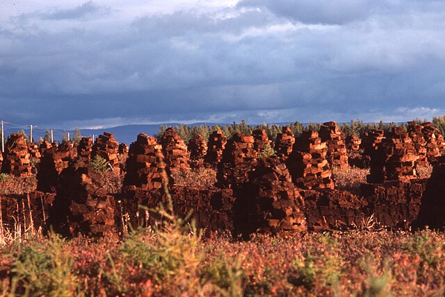
Tourbière Pearl Inc, peat bog and peat to dry
Summary[edit]
| Description |
English: 47° 24' 00" N - 070° 23' 26" W, MRC Charlevoix, L'Isle-aux-Coudres, Pearl Bog Inc., 350, Chemin de la Traverse, L'Isle-aux-Coudres.
Français : 47° 24' 00" N - 070° 23' 26" O, MRC Charlevoix, L'Isle-aux-Coudres, Tourbière Pearl Inc, 350, Chemin de la Traverse, L'Isle-aux-Coudres. |
| Date | |
| Source | Own work |
| Author | Nichole Ouellette/G. Lapointe |
| Camera location | | View this and other nearby images on: OpenStreetMap |
|---|
- More infos/photos, same author: ouellette001.com/florelaurentienne.com
- Québec en photos – Île aux Coudres Flore
- Fleuve Saint-Laurent, Pointe du Bout d'en Bas (Cap)
- Vue sur la côte de Charlevoix et la chaîne montagneuse des Laurentides, 1976
- Chapelle processorale et ancien cimetière de Saint-Louis-de-l'Isle-aux-Coudres, 1976
- About ouellette001.com
Licensing[edit]
I, the copyright holder of this work, hereby publish it under the following license:
This file is licensed under the Creative Commons Attribution 4.0 International license.
- You are free:
- to share – to copy, distribute and transmit the work
- to remix – to adapt the work
- Under the following conditions:
- attribution – You must give appropriate credit, provide a link to the license, and indicate if changes were made. You may do so in any reasonable manner, but not in any way that suggests the licensor endorses you or your use.
File history
Click on a date/time to view the file as it appeared at that time.
| Date/Time | Thumbnail | Dimensions | User | Comment | |
|---|---|---|---|---|---|
| current | 11:29, 30 December 2023 | | 4,117 × 2,752 (4.59 MB) | Nichole Ouellette (talk | contribs) | Uploaded own work with UploadWizard |
You cannot overwrite this file.
File usage on Commons
There are no pages that use this file.
File usage on other wikis
The following other wikis use this file:
- Usage on en.wikipedia.org
- Usage on fr.wikipedia.org