File:衆議院小選挙区 静岡県.svg
Jump to navigation
Jump to search

Size of this PNG preview of this SVG file: 571 × 446 pixels. Other resolutions: 307 × 240 pixels | 615 × 480 pixels | 983 × 768 pixels | 1,280 × 1,000 pixels | 2,560 × 2,000 pixels.
Original file (SVG file, nominally 571 × 446 pixels, file size: 32 KB)
Captions
Captions
Add a one-line explanation of what this file represents
Summary[edit]

|
This file may be updated to reflect new information. If you wish to use a specific version of the file without new updates being mirrored, please upload the required version as a separate file. |
| Description |
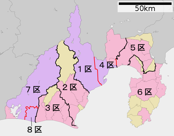
日本語: 衆議院議員小選挙区の静岡県おける区割り。黒線=地方公共団体間の境界線上にある境界。 赤線=同一地方公共団体内にある境界。 水色線=海上または湖沼上での境界。 |
||
| Date | |||
| Source | File:包括自治体区画図 22000.svg(アップロード者はLincun)を元に作成。 | ||
| Author | 猿払の天馬 | ||
| Permission (Reusing this file) |
I, the copyright holder of this work, hereby publish it under the following licenses:
This file is licensed under the Creative Commons Attribution 3.0 Unported license.
You may select the license of your choice. |
||
| Other versions | なし |

File history
Click on a date/time to view the file as it appeared at that time.
| Date/Time | Thumbnail | Dimensions | User | Comment | |
|---|---|---|---|---|---|
| current | 19:53, 4 January 2023 | | 571 × 446 (32 KB) | そらみみ (talk | contribs) | 浜松市の区も変更があるため |
| 17:03, 4 January 2023 |  | 571 × 446 (32 KB) | そらみみ (talk | contribs) | 線の円滑化 | |
| 13:29, 4 January 2023 |  | 571 × 446 (32 KB) | そらみみ (talk | contribs) | 更新 | |
| 04:44, 5 May 2021 |  | 571 × 446 (33 KB) | そらみみ (talk | contribs) | 細部修正 | |
| 08:42, 19 May 2017 |  | 571 × 446 (33 KB) | そらみみ (talk | contribs) | 細部修正 | |
| 09:20, 29 January 2013 |  | 571 × 446 (36 KB) | 猿払の天馬 (talk | contribs) | {{Information |Description=衆議院議員小選挙区の静岡県おける区割り。黒線=地方公共団体間の境界線上にある境界。 赤線=同一地方公共団体内にある境界。 水色線=海上での境界。 |Source=[[:ファ... |
You cannot overwrite this file.
File usage on Commons
The following 3 pages use this file:
File usage on other wikis
The following other wikis use this file:
- Usage on en.wikipedia.org
- Usage on fr.wikipedia.org
- Première circonscription de la préfecture de Shizuoka
- Deuxième circonscription de la préfecture de Shizuoka
- Troisième circonscription de la préfecture de Shizuoka
- Quatrième circonscription de la préfecture de Shizuoka
- Cinquième circonscription de la préfecture de Shizuoka
- Sixième circonscription de la préfecture de Shizuoka
- Septième circonscription de la préfecture de Shizuoka
- Huitième circonscription de la préfecture de Shizuoka
- Usage on ja.wikipedia.org
- Usage on ko.wikipedia.org
- Usage on vi.wikipedia.org
- Usage on zh.wikipedia.org