File:臺灣第一條高速公路—麥克阿瑟公路通車典禮 02.jpg
Jump to navigation
Jump to search

Size of this preview: 800 × 493 pixels. Other resolutions: 320 × 197 pixels | 640 × 394 pixels | 838 × 516 pixels.
Original file (838 × 516 pixels, file size: 51 KB, MIME type: image/jpeg)
Captions
Captions
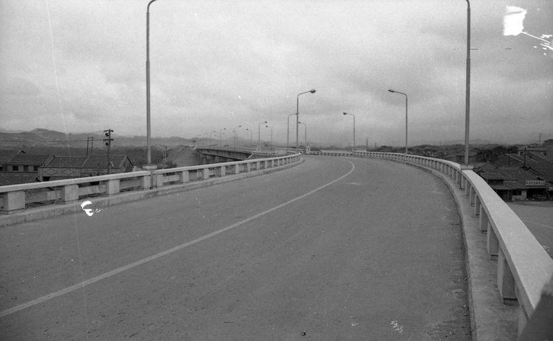
Photo of MacArthur Thruway taken on its opening day, May 2, 1964, published in the Taiwan Shin Sheng Daily News.
Summary[edit]
| Description |
中文:這批相片由台灣新生報記者於1964年5月2日拍攝,主題為麥克阿瑟公路通車典禮。這是臺灣第一條採用立體交叉的高速公路,路線起自臺北市南京東路四段羽球館(今小巨蛋)附近,跨越基隆河,經內湖、汐止、八堵等地,過中興隧道進入基隆市孝二路,全長22.65公里,平原區行車時速可達100公里,全程需時25-30分鐘。臺灣省主席黃杰於羽球館主持通車典禮,交通部長沈怡主持剪綵、美國駐華大使館代辦高立夫等出席,並由公路局長林則彬進行簡報。
1958 年政府為改善臺北與基隆間交通,並基於基隆港物資輸運及國防上需要,決定採新闢道路方案。1960年臺灣省公路局設置北基新路工程處,負責規劃設計及施工,而經費則來自美援。北基新路通車前夕改名為麥克阿瑟公路,以紀念1964年4月5日過世的美國名將麥克阿瑟,俗稱麥帥公路。 囿於經費,麥帥公路由四線道改採無中央分隔兩車道設計,致使行車速度無法提升,及易發生車禍。1970年代隨著南北高速公路的興建,該公路大部分被劃入北基段路線,1979年高速公路通車後僅存麥帥一橋至內湖交流道路段,即現今南京東路六段。 許多人並不知道麥帥公路才是臺灣第一條高速公路,但這條道路仍以不同形式存在於我們周遭,例如國道一號中興隧道原本是麥帥公路的隧道,通往內湖的麥帥一號、二號橋則是這條道路存在過的痕跡。 |
| Date | |
| Source | https://memory.culture.tw/Home/Detail?Id=684697&IndexCode=Culture_Object |
| Author | 台灣新生報 |
Licensing[edit]
 | |
| This file is licensed under the Open Government Data License v1.0 |  |
Note: The license is compatible with the Creative Commons Attribution License 4.0 International. |
File history
Click on a date/time to view the file as it appeared at that time.
| Date/Time | Thumbnail | Dimensions | User | Comment | |
|---|---|---|---|---|---|
| current | 12:32, 22 August 2022 | | 838 × 516 (51 KB) | 源義信 (talk | contribs) | Uploaded a work by 台灣新生報 from https://memory.culture.tw/Home/Detail?Id=684697&IndexCode=Culture_Object with UploadWizard |
You cannot overwrite this file.
File usage on Commons
There are no pages that use this file.
File usage on other wikis
The following other wikis use this file:
- Usage on en.wikipedia.org
- Usage on zh.wikipedia.org