File:岡谷・辰野・塩尻付近 JR路線図.svg
Jump to navigation
Jump to search

Size of this PNG preview of this SVG file: 512 × 362 pixels. Other resolutions: 320 × 226 pixels | 640 × 453 pixels | 1,024 × 724 pixels | 1,280 × 905 pixels | 2,560 × 1,810 pixels.
Original file (SVG file, nominally 512 × 362 pixels, file size: 840 KB)
Captions
Captions
Add a one-line explanation of what this file represents
Summary[edit]
| Description |
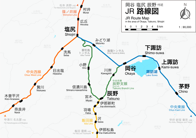
日本語: 中央本線のみどり湖経由および辰野経由のルートを示した地図 国土数値情報「N02 鉄道」「N03 行政区域(長野県)」「W09 湖沼」を使用 |
| Date | |
| Source | Own work |
| Author | Nard.tech ‧ | contributions| uploads |
| Permission (Reusing this file) |
This file is licensed under the Creative Commons Attribution-Share Alike 4.0 International license.
|
| SVG development |
| Annotations | This image is annotated: View the annotations at Commons |
File history
Click on a date/time to view the file as it appeared at that time.
| Date/Time | Thumbnail | Dimensions | User | Comment | |
|---|---|---|---|---|---|
| current | 15:00, 29 April 2017 | | 512 × 362 (840 KB) | Nard.tech (talk | contribs) | 文字色の変更 |
| 00:54, 29 April 2017 |  | 512 × 362 (840 KB) | Nard.tech (talk | contribs) | 市町村名の追加 | |
| 17:00, 28 April 2017 |  | 512 × 362 (764 KB) | Nard.tech (talk | contribs) | デザインの変更 | |
| 17:13, 21 April 2017 |  | 512 × 362 (283 KB) | Nard.tech (talk | contribs) | User created page with UploadWizard |
You cannot overwrite this file.
File usage on Commons
The following 5 pages use this file:
File usage on other wikis
The following other wikis use this file: