File:中央リニア新幹線ルート.gif
Jump to navigation
Jump to search
Size of this preview: 800 × 400 pixels. Other resolutions: 320 × 160 pixels | 640 × 320 pixels | 1,024 × 512 pixels | 1,280 × 640 pixels | 2,200 × 1,100 pixels.
Original file (2,200 × 1,100 pixels, file size: 87 KB, MIME type: image/gif)
Captions
Captions
Add a one-line explanation of what this file represents
Summary[edit]
| Description |
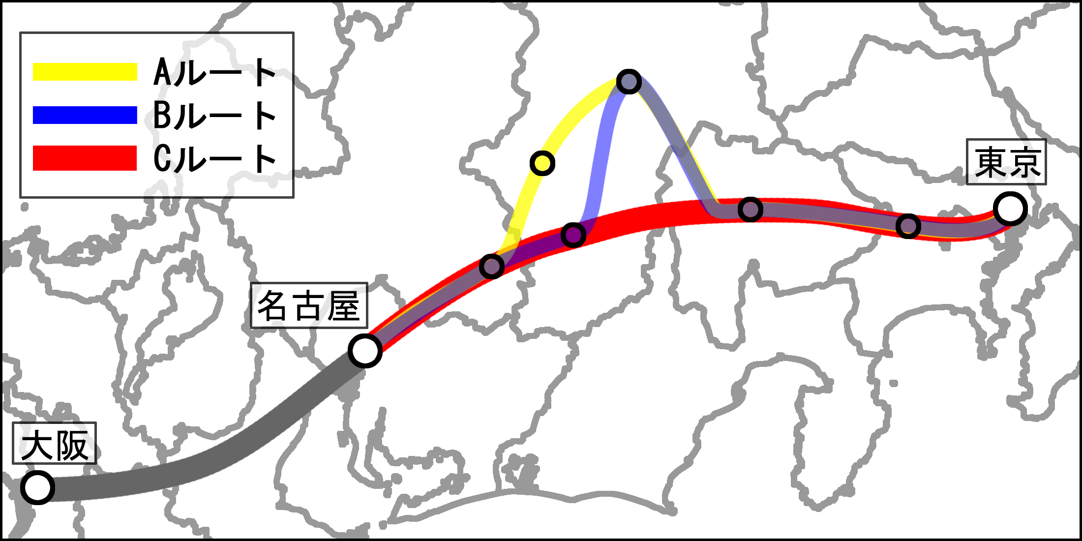
日本語: 中央リニア新幹線の想定ルート。
Aルート:木曽谷ルート(東京-相模原-甲府-諏訪-木曽福島-中津川-名古屋) Bルート:伊那谷ルート(東京-相模原-甲府-諏訪-飯田-中津川-名古屋) Cルート:南アルプスルート(東京-相模原-甲府-飯田-中津川-名古屋)。 Deutsch: Vermutete Route des Chūō-Shinkansen. Route A: Kisodani-Route (Tokio–Sagamihara–Kōfu–Suwa–Kiso–Fukushima–Nakatsugawa–Nagoya) Route B: via Ina-Becken (Chino, Ina, Iida) (Tokio–Sagamihara–Kofu–Suwa–Iida–Nakatsugawa–Nagoya) Route C: unter den Japanischen Alpen und via Iida (Tokio–Sagamihara–Kofu–Iida–Nakatsugawa–Nagoya). |
| Date | |
| Source | http://www.freemap.jp/ で配布されている白地図に自身で描画 |
| Author | 笑む得す努す |
| Permission (Reusing this file) |
Public domain |
Licensing[edit]
| I, the copyright holder of this work, release this work into the public domain. This applies worldwide. In some countries this may not be legally possible; if so: I grant anyone the right to use this work for any purpose, without any conditions, unless such conditions are required by law. |
File history
Click on a date/time to view the file as it appeared at that time.
| Date/Time | Thumbnail | Dimensions | User | Comment | |
|---|---|---|---|---|---|
| current | 14:19, 12 November 2010 | | 2,200 × 1,100 (87 KB) | Shinkansen Fan (talk | contribs) | {{Information |Description=中央リニア新幹線の想定ルート。<br>Aルート:木曽谷ルート(東京-相模原-甲府-諏訪-木曽福島-中津川-名古屋)<br>Bルート:伊那谷ルート(東京-相模原-甲府-諏訪-飯田-中津� |
You cannot overwrite this file.
File usage on Commons
There are no pages that use this file.
File usage on other wikis
The following other wikis use this file:
- Usage on de.wikipedia.org
- Usage on fr.wikipedia.org
- Usage on ja.wikipedia.org
- Usage on ko.wikipedia.org
- Usage on zh.wikipedia.org