File:מפת רכבת ישראל.png
Jump to navigation
Jump to search

Size of this preview: 717 × 600 pixels. Other resolutions: 287 × 240 pixels | 574 × 480 pixels | 918 × 768 pixels | 1,224 × 1,024 pixels | 2,449 × 2,048 pixels | 5,500 × 4,600 pixels.
Original file (5,500 × 4,600 pixels, file size: 414 KB, MIME type: image/png)
Captions
Captions
Add a one-line explanation of what this file represents
Summary[edit]
| Description |
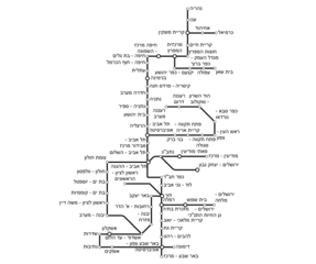
עברית: תרשים תחנות רכבת ישראל |
| Date | |
| Source |
Own work by The original uploader was IKhitron at Hebrew Wikipedia. Original text: יצרתי את הקובץ בעצמי |
| Author |
עברית: יגאל חיטרון (משתמש:IKhitron). |
Imagemap[edit]

Licensing[edit]
| This work has been released into the public domain by its author, IKhitron. This applies worldwide. In some countries this may not be legally possible; if so: IKhitron grants anyone the right to use this work for any purpose, without any conditions, unless such conditions are required by law.
|
Original upload log[edit]
The original description page was here. All following user names refer to he.wikipedia.
| Date/Time | Dimensions | User | Comment |
|---|---|---|---|
| 2016-11-07 11:40 | 5500×4600× (359869 bytes) | IKhitron | תיקון המילה הרצליה |
| 2016-10-17 16:17 | 3624×4600× (628532 bytes) | רונאלדיניו המלך | הסרת השוליים |
| 2016-10-07 11:07 | 5500×4600× (362954 bytes) | IKhitron | תיקון |
| 2016-10-07 10:57 | 5500×4600× (359903 bytes) | IKhitron | עוד חמש תחנות |
| 2016-01-03 13:43 | 5500×4600× (344833 bytes) | IKhitron | |
| 2016-01-02 16:59 | 3233×4599× (373272 bytes) | Ori | |
| 2015-09-13 10:13 | 3233×4599× (360389 bytes) | IKhitron | תיקון |
| 2015-09-13 10:00 | 3313×4591× (361808 bytes) | IKhitron | חיתוך |
| 2015-09-13 09:58 | 5500×4600× (341293 bytes) | IKhitron | עדכון הקו הדרומי |
| 2015-09-06 17:31 | 3193×4531× (339936 bytes) | IKhitron | מוכן. שוחזר לגרסה מ־16:54, 6 בספטמבר 2015 |
| 2015-09-06 17:09 | 5500×4600× (340712 bytes) | IKhitron | זמני להסדרת Imagemap |
| 2015-09-06 17:08 | 3193×4531× (339936 bytes) | IKhitron | שוחזר לגרסה מ־16:54, 6 בספטמבר 2015 |
| 2015-09-06 17:07 | 3193×4531× (339936 bytes) | IKhitron | == תקציר == {{מידע |תיאור=תרשים תחנות רקבת ישראל |מקור=יצרתי את הקובץ בעצמי |תאריך יצירה=4 בספטמבר 2015 |יוצר=יגאל חיטרון ([[משתמש:IKhitron]]) |אישורים ו... |
| 2015-09-06 16:54 | 3193×4531× (339936 bytes) | בנימין | חיתוך השוליים |
| 2015-09-04 19:18 | 5500×4600× (340712 bytes) | IKhitron | תיקון טעות |
| 2015-09-04 18:30 | 5500×4600× (340782 bytes) | IKhitron | == תקציר == {{מידע |תיאור=תרשים תחנות רקבת ישראל |מקור=יצרתי את הקובץ בעצמי |תאריך יצירה=4 בספטמבר 2015 |יוצר=יגאל חיטרון ([[משתמש:IKhitron]]) |אישורים ו... |
File history
Click on a date/time to view the file as it appeared at that time.
| Date/Time | Thumbnail | Dimensions | User | Comment | |
|---|---|---|---|---|---|
| current | 15:34, 30 May 2019 | | 5,500 × 4,600 (414 KB) | IKhitron (talk | contribs) | שיפור גובה |
| 12:19, 30 May 2019 |  | 5,500 × 4,600 (414 KB) | IKhitron (talk | contribs) | מזכרת בתיה | |
| 17:57, 21 September 2018 |  | 5,500 × 4,600 (411 KB) | IKhitron (talk | contribs) | יצחק נבון | |
| 10:52, 17 September 2018 |  | 5,500 × 4,600 (401 KB) | IKhitron (talk | contribs) | תיקון מרחק | |
| 10:49, 17 September 2018 |  | 5,500 × 4,600 (401 KB) | IKhitron (talk | contribs) | קריית מלאכי - יואב | |
| 13:20, 1 July 2018 |  | 5,500 × 4,600 (396 KB) | IKhitron (talk | contribs) | מרכזית המפרץ, רעננה דרום, רעננה מערב | |
| 14:03, 24 September 2017 |  | 5,500 × 4,600 (404 KB) | IKhitron (talk | contribs) | Added two new stations | |
| 11:57, 8 November 2016 |  | 5,500 × 4,600 (354 KB) | IKhitron (talk | contribs) | Fixed a missed station, I'm the original creator | |
| 13:53, 7 November 2016 |  | 5,500 × 4,600 (351 KB) | Geagea (talk | contribs) | Transferred from he.wikipedia |
You cannot overwrite this file.
File usage on Commons
The following 27 pages use this file:
- User:Chumwa/OgreBot/Potential transport maps/2017 September 21-30
- User:Chumwa/OgreBot/Potential transport maps/2018 July 1-10
- User:Chumwa/OgreBot/Potential transport maps/2018 September 11-20
- User:Chumwa/OgreBot/Potential transport maps/2018 September 21-30
- User:Chumwa/OgreBot/Potential transport maps/2019 May 21-31
- User:Chumwa/OgreBot/Public transport information/2017 September 21-30
- User:Chumwa/OgreBot/Public transport information/2018 July 1-10
- User:Chumwa/OgreBot/Public transport information/2018 September 11-20
- User:Chumwa/OgreBot/Public transport information/2018 September 21-30
- User:Chumwa/OgreBot/Public transport information/2019 May 21-31
- User:Chumwa/OgreBot/Transport Maps/2017 September 21-30
- User:Chumwa/OgreBot/Transport Maps/2018 July 1-10
- User:Chumwa/OgreBot/Transport Maps/2018 September 11-20
- User:Chumwa/OgreBot/Transport Maps/2018 September 21-30
- User:Chumwa/OgreBot/Transport Maps/2019 May 21-31
- User:Chumwa/OgreBot/Travel and communication maps/2017 September 21-30
- User:Chumwa/OgreBot/Travel and communication maps/2018 July 1-10
- User:Chumwa/OgreBot/Travel and communication maps/2018 September 11-20
- User:Chumwa/OgreBot/Travel and communication maps/2018 September 21-30
- User:Chumwa/OgreBot/Travel and communication maps/2019 May 21-31
- User:Geagea/Israel/2016 November 7
- User:Geagea/Israel/2016 November 8
- User:Geagea/Israel/2017 September 24
- User:Geagea/Israel/2018 July 1
- User:Geagea/Israel/2018 September 17
- User:Geagea/Israel/2018 September 21
- File:מפת רכבת ישראל.png
File usage on other wikis
The following other wikis use this file:
- Usage on he.wikipedia.org