File:Рељефна карта Црног мора sr.svg
Jump to navigation
Jump to search

Size of this PNG preview of this SVG file: 532 × 331 pixels. Other resolutions: 320 × 199 pixels | 640 × 398 pixels | 1,024 × 637 pixels | 1,280 × 796 pixels | 2,560 × 1,593 pixels.
Original file (SVG file, nominally 532 × 331 pixels, file size: 4.6 MB)
Captions
Captions
Add a one-line explanation of what this file represents
Summary[edit]
| Description |
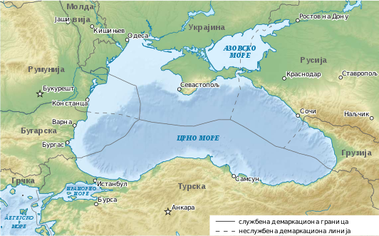
Српски / srpski: Рељефна карта басена Црног мора на српском језику. Оригинална верзија је преузета са википедије на немачком језику (File:Ausschliessliche Wirtschaftszonen Schwarzes Meer (Reliefkarte).svg) |
| Date | 5 February 2013 (original upload date) |
| Source | Transferred from sr.wikipedia to Commons. |
| Author | The original uploader was НиколаБ at Serbian Wikipedia. |
| Permission (Reusing this file) |
CC-BY-SA-3.0-RS. |
.svg)
Licensing[edit]
The original uploader was НиколаБ at Serbian Wikipedia., the copyright holder of this work, hereby publishes it under the following licenses:

|
Permission is granted to copy, distribute and/or modify this document under the terms of the GNU Free Documentation License, Version 1.2 or any later version published by the Free Software Foundation; with no Invariant Sections, no Front-Cover Texts, and no Back-Cover Texts. A copy of the license is included in the section entitled GNU Free Documentation License. Subject to disclaimers. |
This file is licensed under the Creative Commons Attribution 3.0 Serbia license.
Attribution: The original uploader was НиколаБ at Serbian Wikipedia.
- You are free:
- to share – to copy, distribute and transmit the work
- to remix – to adapt the work
- Under the following conditions:
- attribution – You must give appropriate credit, provide a link to the license, and indicate if changes were made. You may do so in any reasonable manner, but not in any way that suggests the licensor endorses you or your use.

You may select the license of your choice.
Original upload log[edit]
The original description page was here. All following user names refer to sr.wikipedia.
| Date/Time | Dimensions | User | Comment |
|---|---|---|---|
| 2013-02-05 16:11 | 532×331× (4825191 bytes) | НиколаБ | Рељефна карта басена Црног мора на српском језику. Оригинална верзија је преузета са википедије на немачком језику ([http://commons.wikimedia.org/wiki/File… |
File history
Click on a date/time to view the file as it appeared at that time.
| Date/Time | Thumbnail | Dimensions | User | Comment | |
|---|---|---|---|---|---|
| current | 12:24, 20 October 2016 | | 532 × 331 (4.6 MB) | Ранко Николић (talk | contribs) | Transferred from sr.wikipedia |
You cannot overwrite this file.
File usage on Commons
There are no pages that use this file.