File:Лабрадорско Море.svg
Jump to navigation
Jump to search

Size of this PNG preview of this SVG file: 758 × 600 pixels. Other resolutions: 304 × 240 pixels | 607 × 480 pixels | 971 × 768 pixels | 1,280 × 1,013 pixels | 2,560 × 2,025 pixels | 785 × 621 pixels.
Original file (SVG file, nominally 785 × 621 pixels, file size: 199 KB)
Captions
Captions
Add a one-line explanation of what this file represents
Summary[edit]
| Description |
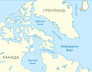
Македонски: Карта на Лабрадорското Море и околните водни површини.
English: Map of the Labrador Sea and the surrounding seas, in Macedonian. |
| Date | (UTC) |
| Source |
This file was derived from: Blank map of Canada.svg: |
| Author |
|
.svg)
| This is a retouched picture, which means that it has been digitally altered from its original version. Modifications: Added seas, changed colours and some text. The original can be viewed here: Blank map of Canada.svg:
|
Licensing[edit]
I, the copyright holder of this work, hereby publish it under the following license:
This file is licensed under the Creative Commons Attribution-Share Alike 3.0 Unported license.
- You are free:
- to share – to copy, distribute and transmit the work
- to remix – to adapt the work
- Under the following conditions:
- attribution – You must give appropriate credit, provide a link to the license, and indicate if changes were made. You may do so in any reasonable manner, but not in any way that suggests the licensor endorses you or your use.
- share alike – If you remix, transform, or build upon the material, you must distribute your contributions under the same or compatible license as the original.
Original upload log[edit]
This image is a derivative work of the following images:
- File:Blank_map_of_Canada.svg licensed with Cc-by-sa-3.0
- 2011-12-14T22:10:03Z Riba 1085x921 (84164 Bytes) == {{int:filedesc}} == {{Information |Description={{Multilingual description |en= Blank map showing provinces and territories of Canada. |fr= Carte vierge montrant les provinces et les territoires du Canada. |de=Karte von Kan
Uploaded with derivativeFX
File history
Click on a date/time to view the file as it appeared at that time.
| Date/Time | Thumbnail | Dimensions | User | Comment | |
|---|---|---|---|---|---|
| current | 02:14, 14 February 2012 | | 785 × 621 (199 KB) | Bjankuloski06en (talk | contribs) | == {{int:filedesc}} == {{Information |Description={{mk|Карта на Лабрадорското Море и околните мориња.}} {{en|Map of the Labrador Sea and the surrounding seas, in Macedonian}} |Source={{Derived from|Blank_map_of_Canad |
You cannot overwrite this file.
File usage on Commons
There are no pages that use this file.
File usage on other wikis
The following other wikis use this file:
- Usage on mk.wikipedia.org