File:Карта к статье «Мурман». Военная энциклопедия Сытина (Санкт-Петербург, 1911-1915).jpg
Jump to navigation
Jump to search

Size of this preview: 800 × 544 pixels. Other resolutions: 320 × 218 pixels | 640 × 436 pixels | 1,024 × 697 pixels | 1,280 × 871 pixels | 2,560 × 1,742 pixels | 3,945 × 2,685 pixels.
Original file (3,945 × 2,685 pixels, file size: 1.1 MB, MIME type: image/jpeg)
Captions
Captions
Add a one-line explanation of what this file represents
Summary
[edit].jpg&action=edit§ion=1)
| Description |
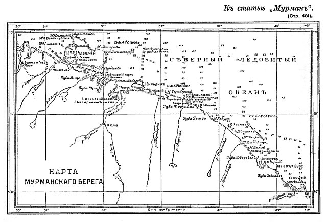
Русский: Этот рисунок был использован для иллюстрирования статьи «Мурман» опубликованной в шестнадцатом томе «Военной энциклопедии», который был издан книгоиздательским товариществом И. Д. Сытина в 1914 году в столице Российской империи городе Санкт-Петербурге. Более подробное описание к этой иллюстрации можно прочесть в указанной выше статье на сайте Русской Викитеки.
English: The Murman Coast is a coastal area in Murmansk Oblast in northwest Russia. It is located on the southern side of the Barents Sea, between the Norway–Russia border and Cape Svyatoy Nos. The major rivers flowing to the sea at the coast are the Tuloma and the Voronya.
Беларуская: Му́рманскі бе́рег — скалісты і слаба расчлянёны бераг Баранцава мора ад Нарвежскай мяжы да мыса Святы Нос. Мае некалькі заліваў (Кольскі, Мотаўскі і іншыя), якія глыбока ўразаюцца ў бераг, уздоўж берага — шэраг астравоў (найбольш буйны — Кільдзін).
Français : La côte mourmane (en russe : Мурманский берег) est une zone côtière située dans l'oblast de Mourmansk au nord-ouest de la Russie. Elle s'étend au sud de la mer de Barents, entre la frontière entre la Norvège et la Russie et le cap Sviatoï Nos, sur la péninsule de Kola. Les principaux fleuve se jetant dans la mer de Barents sont le Touloma et le Voronia.
Nederlands: Moermankust (Russisch: Мурманский берег; Moermanski bereg; "noormannenkust") is een rotsachtig en licht ingesneden kustgebied langs de Barentszzee in Rusland.
Cebuano: Baybayon ang Murmanskiy Bereg (Rinuso: Мурманский Берег) sa Rusya. Nahimutang ni sa lalawigan sa Murmanskaya Oblast', sa kasadpang bahin sa nasod, 1,400 km sa amihanan sa Moscow ang ulohan sa nasod.
Српски / srpski: Мурманска обала (рус. Му́рманский бе́рег), раније само Мурман (рус. Му́рман) и Поморска обала (рус. Помо́рский бе́рег) назив је за део обале Баренцовог мора на подручју Мурманске области Русије, на потезу од норвешке границе на западу до рта Свјатој Нос на истоку. Источно од рта Свјатој Нос је Терска обала Белог мора.
Eesti: Muurmani rannik (ka Murmani rannik; vene keeles Мурманский берег) on Barentsi mere rannik, mis ulatub Venemaa-Norra riigipiirist kuni Svjatoi Nossini; rannik jääb halduslikult Venemaale Murmanski oblastisse. Rannik on kaljune ja vähe liigestunud. Ranniku lähedal on mitmeid saari, millest suurim on Kildin. Rannikul asuvatest sadamatest on kõige olulisem Murmanski sadam. |
| Date | before 1915 |
| Source | «Военная энциклопедия И. Д. Сытина». (Санкт-Петербург; 1914 год). Том № 16. |
| Author | «ВЭС». (СПб; 1914 год). |
Licensing
[edit].jpg&action=edit§ion=2)
|
This work is in the public domain in its country of origin and other countries and areas where the copyright term is the author's life plus 70 years or fewer. This work is in the public domain in the United States because it was published (or registered with the U.S. Copyright Office) before January 1, 1929. | |
| This file has been identified as being free of known restrictions under copyright law, including all related and neighboring rights. | |
File history
Click on a date/time to view the file as it appeared at that time.
| Date/Time | Thumbnail | Dimensions | User | Comment | |
|---|---|---|---|---|---|
| current | 07:47, 10 August 2018 | | 3,945 × 2,685 (1.1 MB) | Schekinov Alexey Victorovich (talk | contribs) | User created page with UploadWizard |
You cannot overwrite this file.
File usage on Commons
There are no pages that use this file.
File usage on other wikis
The following other wikis use this file:
- Usage on ru.wikisource.org
- Usage on www.wikidata.org
.jpg&oldid=324618800)