File:"Aldersgate Flame". Sculpture marking John Wesley's conversion experience (48329375091).jpg
Original file (3,000 × 4,000 pixels, file size: 2.24 MB, MIME type: image/jpeg)
Captions
Captions
Summary
Object
| Aldersgate Flame
|
||||||||||||||||||||||||
|---|---|---|---|---|---|---|---|---|---|---|---|---|---|---|---|---|---|---|---|---|---|---|---|---|
| Title |
Aldersgate Flame |
 | ||||||||||||||||||||||
| Object type |
sculpture |
|||||||||||||||||||||||
| Genre |
public art |
|||||||||||||||||||||||
| Description |
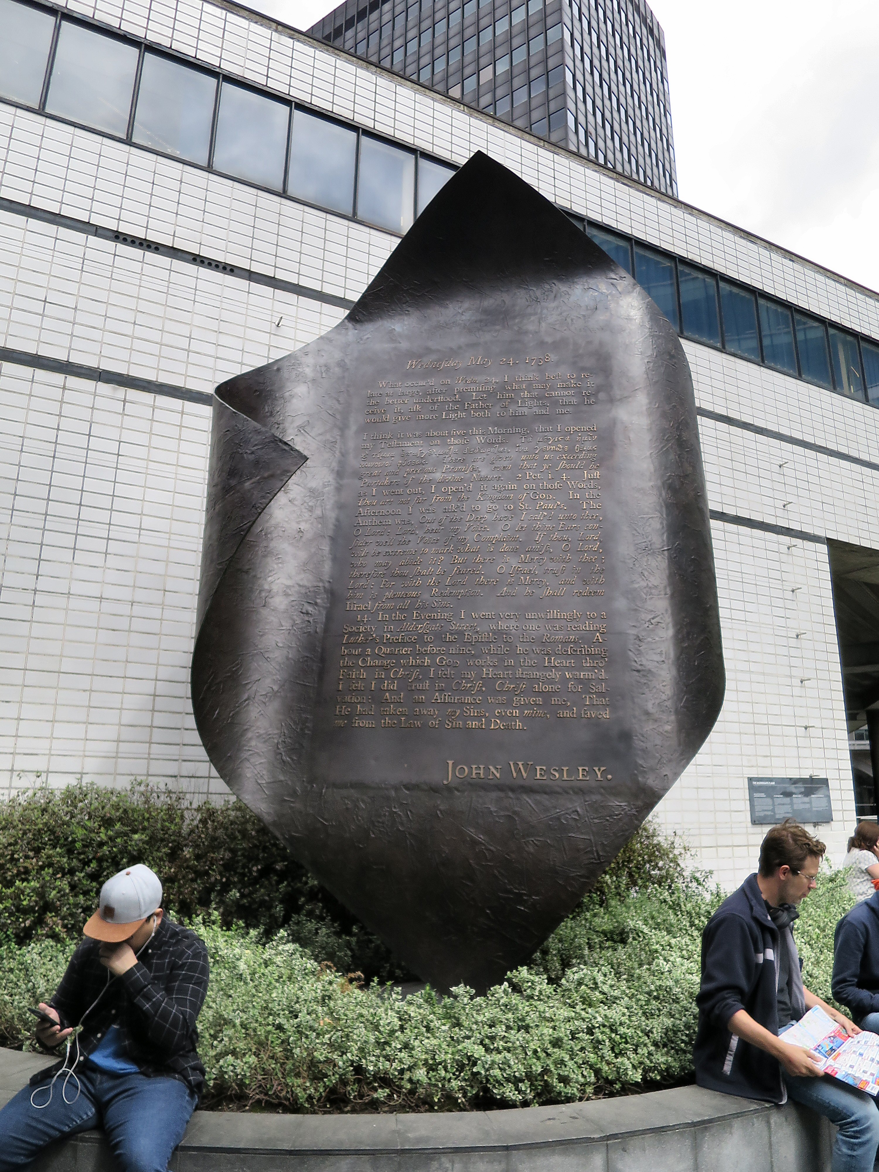
The bronze sculpture was erected in 1981. It is sited at the approximate location of John Wesley's conversion experience on 24 May 1738. The text is an excerpt from Wesley's journal. The key final paragraph is also set out on <a href="https://en.wikipedia.org/wiki/John_Wesley#Wesley's_" rel="noreferrer nofollow">a Wikipedia page</a> about the "Aldersgate Flame" and John Wesley. I've slightly edited my original photo to increase contrast and sharpness and make it easier to read. I also recommend viewing the <a href="https://www.flickr.com/photos/alanstanton/48329375091/sizes/o/"> largest (original) size</a> photo. (As was customary in 1738, the tall/elongated letter 's' is written like a sloping 'f' without a bar.) The sculpture is on a public walkway above the street outside the entrance to the Museum of London. This is located at the junction of Aldersgate Street and the road now known as "London Wall". This refers to the few remaining parts of the original medieval city wall, which enclosed the area now known as the City of London. "The City" for short. The Museum is a short walk from Barbican tube station (London Underground). It's part of The Barbican Estate. This area was heavily bombed during World War II. It's in the Cripplegate ward of the City of London which was virtually demolished. By 1951 the resident population of the City stood at 5,324 of whom 48 lived in Cripplegate. § Wikipedia link to <a href="https://en.wikipedia.org/wiki/Barbican_Estate" rel="noreferrer nofollow">the Barbican Estate</a> - accessed 20 July 2019.) [...]The estate was built between 1965 and 1976, on a 35-acre (14 ha) site that had been bombed in World War II. [...] The flats reflect the widespread use in Britain in the 1960s and 1970s of concrete as the visible face of the building." |
|||||||||||||||||||||||
| Date |
1981 |
|||||||||||||||||||||||
| Medium |
bronze |
|||||||||||||||||||||||
| Collection |
|
|||||||||||||||||||||||
| Object location |
|
|||||||||||||||||||||||
| Object history |
|
|||||||||||||||||||||||

.jpg¶ms=051.517667_N_-000.096333_E_globe:Earth_class:object_type:object__&language=en)
Photograph
| Date | |
| Source | "Aldersgate Flame". Sculpture marking John Wesley's conversion experience |
| Author | Alan Stanton |
| Camera location | | View this and other nearby images on: OpenStreetMap |
|---|
.jpg¶ms=051.518062_N_-000.096668_E_globe:Earth_type:camera_source:Flickr_&language=en)
Licensing
| This file is made available under the Creative Commons CC0 1.0 Universal Public Domain Dedication. | |
| The person who associated a work with this deed has dedicated the work to the public domain by waiving all of their rights to the work worldwide under copyright law, including all related and neighboring rights, to the extent allowed by law. You can copy, modify, distribute and perform the work, even for commercial purposes, all without asking permission.
|
| This image was originally posted to Flickr by Alan Stanton at https://flickr.com/photos/53921762@N00/48329375091 (archive). It was reviewed on 29 November 2019 by FlickreviewR 2 and was confirmed to be licensed under the terms of the cc-zero. |
File history
Click on a date/time to view the file as it appeared at that time.
| Date/Time | Thumbnail | Dimensions | User | Comment | |
|---|---|---|---|---|---|
| current | 18:36, 29 November 2019 | | 3,000 × 4,000 (2.24 MB) | Ham II (talk | contribs) | Transferred from Flickr via #flickr2commons |
You cannot overwrite this file.
File usage on Commons
The following page uses this file:
.jpg)
File usage on other wikis
The following other wikis use this file:
- Usage on de.wikipedia.org
.jpg&oldid=731696964)