Commons:Featured picture candidates/File:Hohes Ufer zwischen Ahrenshoop und Wustrow.jpg
Jump to navigation
Jump to search

File:Hohes Ufer zwischen Ahrenshoop und Wustrow.jpg, featured[edit]
Voting period is over. Please don't add any new votes.Voting period ends on 5 Dec 2022 at 10:55:01 (UTC)
Visit the nomination page to add or modify image notes.

- Gallery: Commons:Featured pictures/Places/Natural/Germany#Mecklenburg-Vorpommern
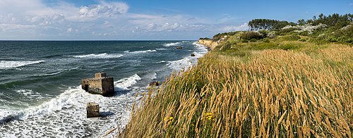
 Info Coast of the Baltic Sea between Ahrenshoop and Wustrow, Fischland, Mecklenburg-Western Pomerania, Germany. All by me -- Milseburg (talk) 10:55, 26 November 2022 (UTC)
 Support -- Milseburg (talk) 10:55, 26 November 2022 (UTC)
- Support Varied and interesting composition. -- Radomianin (talk) 18:53, 26 November 2022 (UTC)
 Question Is there some historical significance to the concrete remains? Charlesjsharp (talk) 21:51, 26 November 2022 (UTC)
 Oppose Unexplained concrete remains.
 Comment Thank you – another good one for my collection of funny oppose reasons :–). --Aristeas (talk) 09:22, 30 November 2022 (UTC)
- Why funny oppose reason? If they were meaningless concrete rubbish, then it would be a poor composition. But the author has recently confirmed they have historical significance. Charlesjsharp (talk) 14:05, 30 November 2022 (UTC)
- Comment Sorry, Charles, I really thought you were just kidding, giving us a nice example of British humour. --Aristeas (talk) 18:22, 30 November 2022 (UTC)
- Info Thanks for your query, Charles. The concrete blocks are part of bunkers built by the GDR regime, which have historical value. They were constructed between 1957 and 1959 and housed a thermal direction finder. The Hohes Ufer coastal section in particular provided nearly perfect conditions for air and sea observation. The site was abandoned in 1989 due to coastal erosion. Hope the information is useful for explanation. Best, -- Radomianin (talk) 10:55, 30 November 2022 (UTC)
- Support Excellent composition. Cmao20 (talk) 16:11, 27 November 2022 (UTC)
- Support --Wieggy (talk) 00:18, 28 November 2022 (UTC)
- Support--Agnes Monkelbaan (talk) 10:43, 28 November 2022 (UTC)
- Support --Frank Schulenburg (talk) 04:24, 29 November 2022 (UTC)
- Support -- IamMM (talk) 09:06, 29 November 2022 (UTC)
- Support --Aristeas (talk) 09:22, 30 November 2022 (UTC)
- Support --XRay 💬 12:54, 30 November 2022 (UTC)
- Support --Llez (talk) 14:47, 30 November 2022 (UTC)
- Support Daniel Case (talk) 03:53, 1 December 2022 (UTC)
Confirmed results:
Result: 11 support, 0 oppose, 0 neutral → featured. /--A.Savin 14:22, 1 December 2022 (UTC)
This image will be added to the FP gallery: Places/Natural/Germany#Mecklenburg-Vorpommern