Commons:Featured picture candidates/File:Geographic map of Somaliland.svg
Jump to navigation
Jump to search

File:Geographic map of Somaliland.svg, featured[edit]
Voting period is over. Please don't add any new votes.Voting period ends on 13 Oct 2021 at 05:22:36 (UTC)
Visit the nomination page to add or modify image notes.

- Gallery: Commons:Featured pictures/Non-photographic media/Maps#Maps of Africa
 Info created by Ikonact - uploaded by Ikonact - nominated by Siirski -- Siirski (talk) 05:22, 4 October 2021 (UTC)
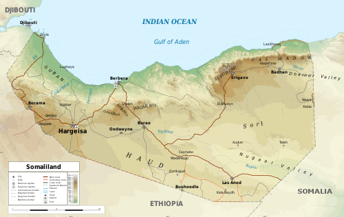
- Info Geography map of Somaliland in English, easy to translate.
 Support -- Siirski (talk) 05:22, 4 October 2021 (UTC)
- Support Additional names of wadis would be welcome, but it's a nice map and I give it my support. -- Ikan Kekek (talk) 06:51, 5 October 2021 (UTC)
- Support Clean and clear map. – Gallery link refined. ;–). --Aristeas (talk) 10:24, 5 October 2021 (UTC)
- Support --Commonists 19:53, 5 October 2021 (UTC)
- Support per Ikan and Aristeas -- Radomianin (talk) 20:11, 5 October 2021 (UTC)
- Support--Agnes Monkelbaan (talk) 09:40, 6 October 2021 (UTC)
- Support --Llez (talk) 14:11, 6 October 2021 (UTC)
- Support A very professional-quality map. Daniel Case (talk) 18:03, 6 October 2021 (UTC)
- Support --Ivar (talk) 16:16, 7 October 2021 (UTC)
- Support --Famberhorst (talk) 17:47, 9 October 2021 (UTC)
Confirmed results:
This image will be added to the FP gallery: Non-photographic media/Maps#Maps of Africa