Commons:Featured picture candidates/File:Earth western hemisphere from Suomi NPP.jpg
Jump to navigation
Jump to search

File:North America from low orbiting satellite Suomi NPP.jpg, not featured[edit]
Voting period is over. Please don't add any new votes.Voting period ends on 4 Feb 2012 at 04:18:16 (UTC)
Visit the nomination page to add or modify image notes.

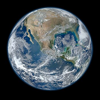
 Info created by NASA/NOAA/GSFC/Suomi NPP/VIIRS/Norman Kuring, uploaded by and nominated by -- Hellbus (talk) 04:18, 26 January 2012 (UTC)
 Support -- Hellbus (talk) 04:18, 26 January 2012 (UTC) Very high resolution (64 megapixels) and sharp focus throughout.
- I change my vote. Nice but wrong proportions. Yann (talk) 06:24, 28 January 2012 (UTC)
*
![]() Support wow it's my favourite picture. our blue planet :)--David საქართველო 09:47, 26 January 2012 (UTC)
Support wow it's my favourite picture. our blue planet :)--David საქართველო 09:47, 26 January 2012 (UTC)
- Support Nice! --Chmee2 (talk) 10:33, 26 January 2012 (UTC)
- Support --Aleks G (talk) 17:20, 26 January 2012 (UTC)
* Yet another NASA picture of the earth... I prefer pictures made by wikimedians.--Jebulon (talk) 13:54, 26 January 2012 (UTC)
![]() Neutral Not bad.
Neutral Not bad.
 Oppose. The size of landforms is not the normal one and gives a false impression. Thierry Caro (talk) 14:53, 26 January 2012 (UTC)
- Support -Erick- Talk 16:16, 26 January 2012 (UTC)
- Support - Awesome high-res photo of Earth! --versageek (talk) 21:17, 26 January 2012 (UTC)
- Support nice shot Mamad TALK
- Support Cathy Richards (talk) 22:44, 26 January 2012 (UTC)
- Support I think I can see my house. --AlphaEta (talk) 23:59, 26 January 2012 (UTC)
- Support Tomer T (talk) 07:10, 27 January 2012 (UTC)
- Oppose Ouch!! per Thierry Caro พ.s. 09:22, 27 January 2012 (UTC)
- Oppose I change my vote, Per Thierry Caro and ws. Is the Gulf of Mexico so bright ?--Jebulon (talk) 12:58, 27 January 2012 (UTC)
- Brightness in the Gulf could be due to algal blooms. พ.s. 13:05, 27 January 2012 (UTC)
- Misunderstanding, my mistake, due to poor english. I meant "large", "wide", about the visual distortion. Sorry.--Jebulon (talk) 13:18, 27 January 2012 (UTC)
- Oppose I just read Thierry Caro's comment, then noticed inmediately the wrong proportions. It's weird how one doesn't notice such an important detail at first sight. This is really misrepresentative of the earth. Not really encyclopedic, au contraire. That planet looks like Americaland, not the earth. I heard on the radio about this pic from NASA. Why would (on purpose??) NASA make this unrealistic representation? As if they could not do a perfect job... --Paolo Costa (talk) 14:27, 27 January 2012 (UTC)
- Oppose confusing and unexplained distortion, as remarked above. --ELEKHHT 15:00, 27 January 2012 (UTC)
- Support Wow! –ElmA (Talk – My files – E-mail) 16:45, 27 January 2012 (UTC)
.svg)
- I won't oppose due to explanation about satellite position. --Lošmi (talk) 03:52, 4 February 2012 (UTC)
- Oppose--David საქართველო 20:52, 27 January 2012 (UTC)
 Comment I hadn't really paid that much attention to the proportions before, but now I see it too. It looks a bit like fisheye-distorted view, but I can only guess. Hellbus (talk) 23:13, 27 January 2012 (UTC)
 Neutral The picture has probably been taken so close to the Earth that it got a fish eye like effect which, in this case, makes the USA look quite enormous compared to the apparent "diameter" of the Earth seen here. This is an important matter which should be mentioned about this picture! Otherwise the picture would really mislead less attentive people. What comes to the picture itself, it is really beautiful and detailed... But..! --Ximonic (talk) 07:01, 28 January 2012 (UTC)
- Because the satellite seems to be named as Suomi which means Finland (even though it was named after Verner E. Suomi) they should take this kind of fish eye picture where Finland fills the entire half of globe. :-) Let's talk about false impression after that... --Ximonic (talk) 07:08, 28 January 2012 (UTC)
- Oppose as above. -- -donald- (talk) 12:55, 28 January 2012 (UTC)
- Oppose as above. --Alchemist-hp (talk) 22:09, 28 January 2012 (UTC)
- Oppose as above. -- Achird (talk) 23:29, 28 January 2012 (UTC)
- Comment -- Ximonic is right, the picture has probably been taken so close to the Earth that a substancial part of the visible hemisphere is "behind the horizon". Take the Earth representation in Google Earth and imagine cropping the image with a smaller circle. The result is similar to the present picture. This is not a distortion, in the sense people is using here, just a close-up. Alvesgaspar (talk) 00:02, 29 January 2012 (UTC)
- Comment For those concerned about the fisheye/cropped aspect of the picture, would amending the description to reflect that fact help? Hellbus (talk) 03:57, 29 January 2012 (UTC)
- Definitely should be explained, as is very different from common perspectives and projections. --ELEKHHT 04:02, 29 January 2012 (UTC)
- I have added the following text to the beginning of the image description. Hellbus (talk) 03:35, 30 January 2012 (UTC) "A view of most of North America taken from a low orbit. This vantage point results in a view that is distorted much like that of a fisheye camera lens, making the land mass appear disproportionately large. NASA description follows."
- Definitely should be explained, as is very different from common perspectives and projections. --ELEKHHT 04:02, 29 January 2012 (UTC)
- Oppose per fisheye effect. -- Kaldari (talk) 08:14, 30 January 2012 (UTC)
- Oppose I'm even considering to propose this "image" for deletion. --Yikrazuul (talk) 17:43, 30 January 2012 (UTC)
- Comment and Support -- I can't understand the animosity against this image. This is not a fisheye effect at all! When looking at a sphere you only see (almost) a full hemisphere when you are very, very far from it. The closer you are the less you see. -- Alvesgaspar (talk) 19:03, 30 January 2012 (UTC)
- I think what is meant by "fish-eye effect" and "distortion" is not that is "artificial" use of a special lens, but that is a very particular perspective, in contrast to the ones we are used to, taken from further away and which are closer to the projections used in mapping. The problem I see is that it does not provide any significant advantage in terms of major additional detail in the centre, while reducing the overview. Furthermore, the distinction from the "standard" perspectives is here ambiguous as some of the usual conventions are kept (i.e. north upwards), and thus the viewers are confused, as well demonstrated above. --ELEKHHT 20:34, 30 January 2012 (UTC)
- Let them be confused, they will undestand and maybe learn something then - isn't this a purpose of the project? Of course the description of file should explain this. --sfu (talk) 22:47, 30 January 2012 (UTC)
- I believe a good image should be self-explanatory. For instance here is clear for anybody that the image is from close-distance (while the description is also more precise). My other argument illustrated, is that I find a good overview more educational. --ELEKHHT 00:13, 31 January 2012 (UTC)
- I don't believe so. I think description is needed sometimes. --sfu (talk) 07:14, 31 January 2012 (UTC)
- Alves you are right with the distance, but it suggests that you see the whole (half) globe, but it isn't so. -- -donald- (talk) 08:08, 31 January 2012 (UTC)
- I don't believe so. I think description is needed sometimes. --sfu (talk) 07:14, 31 January 2012 (UTC)
- I believe a good image should be self-explanatory. For instance here is clear for anybody that the image is from close-distance (while the description is also more precise). My other argument illustrated, is that I find a good overview more educational. --ELEKHHT 00:13, 31 January 2012 (UTC)
- Let them be confused, they will undestand and maybe learn something then - isn't this a purpose of the project? Of course the description of file should explain this. --sfu (talk) 22:47, 30 January 2012 (UTC)
- I think what is meant by "fish-eye effect" and "distortion" is not that is "artificial" use of a special lens, but that is a very particular perspective, in contrast to the ones we are used to, taken from further away and which are closer to the projections used in mapping. The problem I see is that it does not provide any significant advantage in terms of major additional detail in the centre, while reducing the overview. Furthermore, the distinction from the "standard" perspectives is here ambiguous as some of the usual conventions are kept (i.e. north upwards), and thus the viewers are confused, as well demonstrated above. --ELEKHHT 20:34, 30 January 2012 (UTC)
- Support Jes. People. It really looks that way if you are close to the surface. You can only see full hemisphere if you are far enough from the surface. Being very strictl you can only see full hemisphere while being in infinite distance from the sphere. Plese read the: en:Horizon, please. --sfu (talk) 22:29, 30 January 2012 (UTC)
- Comment A shot from the moon is far less than infinite. It would be good enough, no need to go to infinity. It gives a perfectly precise enough idea of what the continents and landmasses sizes are, compared to the total size of the earth. We are not arguing technical facts, fisheye distortions and crazy calculation stuff here, as I've understood. We are just opposing because when a person opens the file gets a wrong proportion of the landmasses, which is not very helpful for an encyclopedia. If I were a learning kid and looked at this picture I'd get confused (what the heck, is the north pole in the grand canyon?? Is California the opposite of Ushuaia? Are Asia plus Europe smaller than America????). Problem here is, that this stitched pano's contour is round, coinciding with the earth roundness. Had it been a circular sector, there would have been no problem. But the file, as it is, is misleading, no matter what we say. It is an extremely cool panoramic image, but it gives more wrong information than it gives right. --Paolo Costa (talk) 05:42, 31 January 2012 (UTC)
- Once again, bacause I have a slight impression that you are trying too suggest it's arifficial: if you where on this height above Mexico as the satellite you would see exacly the same. The fact that it looks that way is a very strage indeed, and that is why it's worth to show it to the people. Of course the decription have to be changed, as now it doesn't mention the word horizon, nor the height of the satellite above the ground. Give people something confusing, and explain to then. Are you really stucked in showing people nice but not surprising views and animals? If look at the picture more carefully you will see that the atmosphere is very thick in it. That's because the satellite was close to the surface. Everything fits, it looks that way. What have to be changed is the description, which should mention the approximate height of the satellite and the link to horizon. It's disturbing, it's true, Great! Then that's what we want (with a good description)! Ok, I'll try to make the description today. --sfu (talk) 07:11, 31 January 2012 (UTC)
- Also the file name have to be changed. --sfu (talk) 07:49, 31 January 2012 (UTC)
 Done --sfu (talk) 09:44, 31 January 2012 (UTC)
- Oppose As per many above on proportions. VasuVR (talk, contribs) 13:13, 3 February 2012 (UTC)
Confirmed results:
Result: 12 support, 12 oppose, 1 neutral → not featured. /George Chernilevsky talk 14:54, 4 February 2012 (UTC)