File:Wrocław - widok z Wyspy Slodowej - wyspa Tamka.jpg
Jump to navigation
Jump to search

Size of this preview: 800 × 490 pixels. Other resolutions: 320 × 196 pixels | 640 × 392 pixels | 1,024 × 627 pixels | 1,280 × 784 pixels | 2,560 × 1,568 pixels | 4,384 × 2,686 pixels.
Original file (4,384 × 2,686 pixels, file size: 2.72 MB, MIME type: image/jpeg)
Captions
Captions
Add a one-line explanation of what this file represents
Summary
[edit]
| Description |
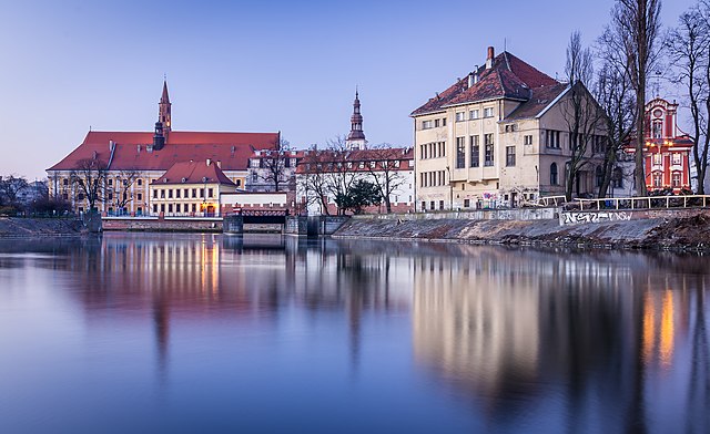
Polski: Wrocław, zespół urbanistyczny Ostrowia Tumskiego i wysp: Piaskowej, Bielarskiej, Słodowej
English: Wrocław, the urban complex of Ostrów Tumski and the islands: Piaskowa, Bielarska, and Słodowa. Ostrów Tumski ("Cathedral Island") is the oldest part of the city of Wrocław in south-western Poland. It was formerly an island between branches of the Oder River.
Español: Vista de isla Tamka en Breslavia (Wrocław), Polonia. En el fondo, el edificio de la Universidad de Breslavia y el Ossolineum.
Français : L'île de Tamka à Wrocław (Pologne), avec en arrière-plan l'Université de Wrocław et l'Ossolineum.
Čeština: Ostrov Tamka v polské Vratislavi s budovami Vratislavské univerzity a knihovnou Ossolineum v pozadí.
Македонски: Островот Тамка во Вроцлав со Вроцлавскиот универзитет и научниот завод „Осолињски“ во позадината.
Português: Vista da ilha Tamka em Breslávia (Wrocław), Polônia. Ao fundo, o edifício da Universidade de Breslávia e o Instituto Nacional Ossoliński
Русский: Остров Тамка во Вроцлаве (Польша). На заднем плане — Вроцлавский университет (слева) и Национальная библиотека имени Оссолинских
Эрзянь: Тамка Усия (Tamka Island) Вроцлав Вроцлавонь университетэнь ды Оссолинеумонь кудотнень удальце ёнкссо. |
| Date | |
| Source | Own work |
| Author | Jar.ciurus |
| Object location | | View this and other nearby images on: OpenStreetMap |
|---|
Assessment
[edit]
|
This image was selected as picture of the day on Wikimedia Commons for 16 September 2020. It was captioned as follows: Other languages:
Čeština: Ostrov Tamka v polské Vratislavi s budovami Vratislavské univerzity a knihovnou Ossolineum v pozadí. Español: Vista de isla Tamka en Breslavia (Wrocław), Polonia. En el fondo, el edificio de la Universidad de Breslavia y el Ossolineum. Français : L'île de Tamka à Wrocław (Pologne), avec en arrière-plan l'Université de Wrocław et l'Ossolineum. Português: Vista da ilha Tamka em Breslávia (Wrocław), Polônia. Ao fundo, o edifício da Universidade de Breslávia e o Instituto Nacional Ossoliński Македонски: Островот Тамка во Вроцлав со Вроцлавскиот универзитет и научниот завод „Осолињски“ во позадината. Русский: Остров Тамка во Вроцлаве (Польша). На заднем плане — Вроцлавский университет (слева) и Национальная библиотека имени Оссолинских |
Licensing
[edit]
I, the copyright holder of this work, hereby publish it under the following license:
This file is licensed under the Creative Commons Attribution-Share Alike 3.0 Poland license.
- You are free:
- to share – to copy, distribute and transmit the work
- to remix – to adapt the work
- Under the following conditions:
- attribution – You must give appropriate credit, provide a link to the license, and indicate if changes were made. You may do so in any reasonable manner, but not in any way that suggests the licensor endorses you or your use.
- share alike – If you remix, transform, or build upon the material, you must distribute your contributions under the same or compatible license as the original.


|
This image was uploaded as part of Wiki Loves Monuments 2014.
|
File history
Click on a date/time to view the file as it appeared at that time.
| Date/Time | Thumbnail | Dimensions | User | Comment | |
|---|---|---|---|---|---|
| current | 20:11, 16 September 2014 | | 4,384 × 2,686 (2.72 MB) | Jar.ciurus (talk | contribs) | Drobna korekta |
| 19:51, 16 September 2014 |  | 4,384 × 2,686 (2.95 MB) | Jar.ciurus (talk | contribs) | User created page with UploadWizard |
You cannot overwrite this file.
File usage on Commons
The following 32 pages use this file:
- User:Cmao20
- User:Firefly/2020-B
- User talk:Cmao20/Archive 2020
- User talk:Jar.ciurus
- Commons:Featured picture candidates/File:Wrocław - widok z Wyspy Slodowej - wyspa Tamka.jpg
- Commons:Featured picture candidates/Log/July 2020
- Commons:Featured pictures/Places/Architecture/Exteriors
- Commons:Featured pictures/chronological/2020-B
- Commons:Featured pictures/chronological/July 2020
- Commons:Picture of the Year/2020/Candidates
- Commons:Picture of the Year/2020/R1/Gallery/2020-B
- Commons:Picture of the Year/2020/R1/Gallery/ALL
- Commons:Picture of the Year/2020/R1/Gallery/M07
- Commons:Picture of the Year/2020/R1/Gallery/Settlements
- Commons:Picture of the Year/2020/R1/v/Wrocław - widok z Wyspy Slodowej - wyspa Tamka.jpg
- Commons:Quality images/Subject/Architecture/Cityscapes
- Commons:Quality images candidates/Archives July 06 2020
- Template:Potd/2020-09
- Template:Potd/2020-09-16
- Template:Potd/2020-09-16 (cs)
- Template:Potd/2020-09-16 (en)
- Template:Potd/2020-09-16 (es)
- Template:Potd/2020-09-16 (fr)
- Template:Potd/2020-09-16 (hu)
- Template:Potd/2020-09-16 (mk)
- Template:Potd/2020-09-16 (myv)
- Template:Potd/2020-09-16 (nl)
- Template:Potd/2020-09-16 (pt)
- Template:Potd/2020-09-16 (pt-br)
- Template:Potd/2020-09-16 (ru)
- Category:History of Lower Silesia
- Category:Lower Silesia
File usage on other wikis
The following other wikis use this file:
- Usage on ar.wikipedia.org
- Usage on crh.wikipedia.org
- Usage on cv.wikipedia.org
- Usage on eo.wikipedia.org
- Usage on fr.wikipedia.org
- Usage on hu.wikipedia.org
- Usage on hy.wikipedia.org
- Usage on ka.wikipedia.org
- Usage on ko.wikipedia.org
- Usage on lbe.wikipedia.org
- Usage on lez.wikipedia.org
- Usage on mk.wikipedia.org
- Usage on os.wikipedia.org
- Usage on pt.wikipedia.org
- Usage on ru.wikipedia.org
- Usage on ru.wikinews.org
- Usage on ru.wikivoyage.org
- Usage on sah.wikipedia.org
- Usage on sh.wikipedia.org
- Usage on sq.wikipedia.org
- Usage on tt.wikipedia.org
- Usage on uk.wikipedia.org
- Usage on vep.wikipedia.org
- Usage on www.wikidata.org
- Usage on zh.wikipedia.org