File:WW2 Holocaust Europe N-E map-fr.svg
Jump to navigation
Jump to search

Size of this PNG preview of this SVG file: 719 × 600 pixels. Other resolutions: 288 × 240 pixels | 575 × 480 pixels | 921 × 768 pixels | 1,227 × 1,024 pixels | 2,455 × 2,048 pixels | 1,268 × 1,058 pixels.
Original file (SVG file, nominally 1,268 × 1,058 pixels, file size: 277 KB)
Captions
Captions
Add a one-line explanation of what this file represents
Summary[edit]
| Description |
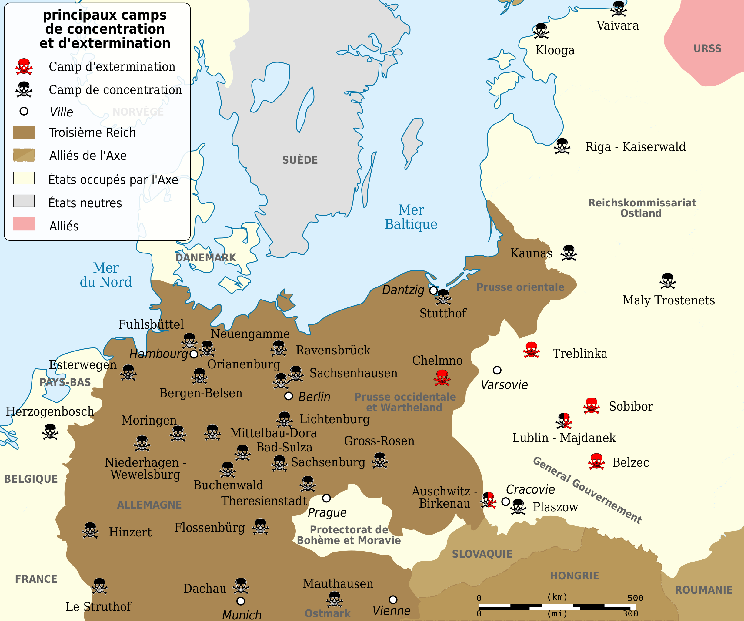
Deutsch: Vernichtungs- und Konzentrationslager während des 2. Weltkrieges, Grenzen von 1943. English: Map of the Holocaust in Europe during World War II, 1939-1945. This map shows all German extermination camps (or death camps), most major concentration camps, labor camps, prison camps, ghettos, major deportation routes and major massacre sites. Notes: 1. Extermination camps were dedicated death camps, but all camps and ghettos took a toll of many, many lives. 2. Concentration camps include labor camps, prison camps & transit camps. 3. Not all camps & ghettos are shown. 4. Borders are at the height of Axis domination (1942). 5. Some regions have German designations (e.g. "Ostland"), with the present country name denoted in uppercase letters in parenthesis below the German designation (e.g. "(AUSTRIA)"). 6. Present (2007) borders are dotted. Español: Campos de concentración y exterminio nazis durante la II Guerra Mundial, fronteras de 1943. Français : Principaux camps de concentrations et d'extermination pendant la deuxième guerre mondiale. Frontières de 1943. Kurdî: Topkırın û kûştîn kamp â Nazi â Alamanê. Polski: Niemieckie obozy koncentracyjne w europie, ze względu na to że obozy zmieniały swe funkcje nie są one rozróżnione na mapie, Granice państw stan z 1943 r. Português: Campos de concentração e extermínio nazistas durante a II Guerra Mundial, fronteiras de 1943. Türkçe: Önemli, Alman Nazi toplama ve yok etme kampları. 1943 sınırları. |
||||
| Date | (UTC) | ||||
| Source | |||||
| Author | |||||
| Other versions |
[]
| ||||
| Attribution (required by the license) | © Sémhur / Wikimedia Commons / | ||||
| SVG | W3C-validity not checked.
|
||||
| Graphic Lab |


.png)


.png)


Licensing[edit]
I, the copyright holder of this work, hereby publish it under the following licenses:
| Copyleft: This work of art is free; you can redistribute it and/or modify it according to terms of the Free Art License. You will find a specimen of this license on the Copyleft Attitude site as well as on other sites. |
This file is licensed under the Creative Commons Attribution-Share Alike Attribution-Share Alike 4.0 International, 3.0 Unported, 2.5 Generic, 2.0 Generic and 1.0 Generic license.
- You are free:
- to share – to copy, distribute and transmit the work
- to remix – to adapt the work
- Under the following conditions:
- attribution – You must give appropriate credit, provide a link to the license, and indicate if changes were made. You may do so in any reasonable manner, but not in any way that suggests the licensor endorses you or your use.
- share alike – If you remix, transform, or build upon the material, you must distribute your contributions under the same or compatible license as the original.
You may select the license of your choice.
Original upload log[edit]
This image is a derivative work of the following images:
- File:Konzentrazionslager.png licensed with GFDL, GFDL/fr
- File:WW2_Holocaust_Europe_map-fr.svg licensed with Cc-by-3.0, Cc-by-3.0/fr
- 2009-05-11T16:52:07Z Sémhur 1310x1090 (607330 Bytes) {{Information |Description=Map of the Holocaust in Europe during World War II, 1939-1945. This map shows all extermination camps (or ''death camps''), most major concentration camps, labor camps, prison camps, ghettos, major
Uploaded with derivativeFX
File history
Click on a date/time to view the file as it appeared at that time.
| Date/Time | Thumbnail | Dimensions | User | Comment | |
|---|---|---|---|---|---|
| current | 17:02, 11 May 2009 | | 1,268 × 1,058 (277 KB) | Sémhur (talk | contribs) | {{Information |Description={{pt|Campos de concentração e extermínio nazistas durante a II Guerra Mundial, fronteiras de 1943}} {{es|Campos de concentración y exterminio nazis durante la II Guerra Mundial, fronteras de 1943}} {{fr|Camps de concentratio |
You cannot overwrite this file.
File usage on Commons
The following 25 pages use this file:
- Atlas of World War II
- File:WW2-Holocaust-Europe-2007Borders.png
- File:WW2-Holocaust-Europe-2007Borders DE.png
- File:WW2-Holocaust-Europe-he.png
- File:WW2-Holocaust-Europe.png
- File:WW2-Holocaust-Europe DE.png
- File:WW2-Holocaust-Europe DE 2.png
- File:WW2-Holocaust-Europe blank.png
- File:WW2-Holocaust-Poland-ru.png
- File:WW2-Holocaust-Poland-ukr.jpg
- File:WW2-Holocaust-Poland.PNG
- File:WW2-Holocaust-Poland (Français).png
- File:WW2-Holocaust-Poland (without comment).png
- File:WW2-Holocaust-Poland big legend.PNG
- File:WW2-Zagłada-Żydów-Polska.png
- File:WW2 Holocaust Europe N-E map-fr.svg
- File:WW2 Holocaust Europe map-blank.svg
- File:WW2 Holocaust Europe map-es.svg
- File:WW2 Holocaust Europe map-fr.svg
- File:WW2 Holocaust Europe map-it.svg
- File:WW2 Holocaust Europe map-pt.svg
- File:WW2 Holocaust Europe map-zh-hans.svg
- File:WW2 Holocaust Poland map-fr.svg
- File:Холокост в Европе.png
- Template:Other versions/WW2 Holocaust Europe map
File usage on other wikis
The following other wikis use this file:
- Usage on br.wikipedia.org
- Usage on fi.wikipedia.org
- Usage on fr.wikipedia.org
- Usage on fr.wikiversity.org
- Usage on sv.wikipedia.org