File:Vexilographic maps of Pontic littoral by end of 13th-17th century.svg
Jump to navigation
Jump to search

Size of this PNG preview of this SVG file: 800 × 437 pixels. Other resolutions: 320 × 175 pixels | 640 × 349 pixels | 1,024 × 559 pixels | 1,280 × 699 pixels | 2,560 × 1,397 pixels | 1,640 × 895 pixels.
Original file (SVG file, nominally 1,640 × 895 pixels, file size: 2.58 MB)
Captions
Captions
Add a one-line explanation of what this file represents
Summary[edit]
| Description |
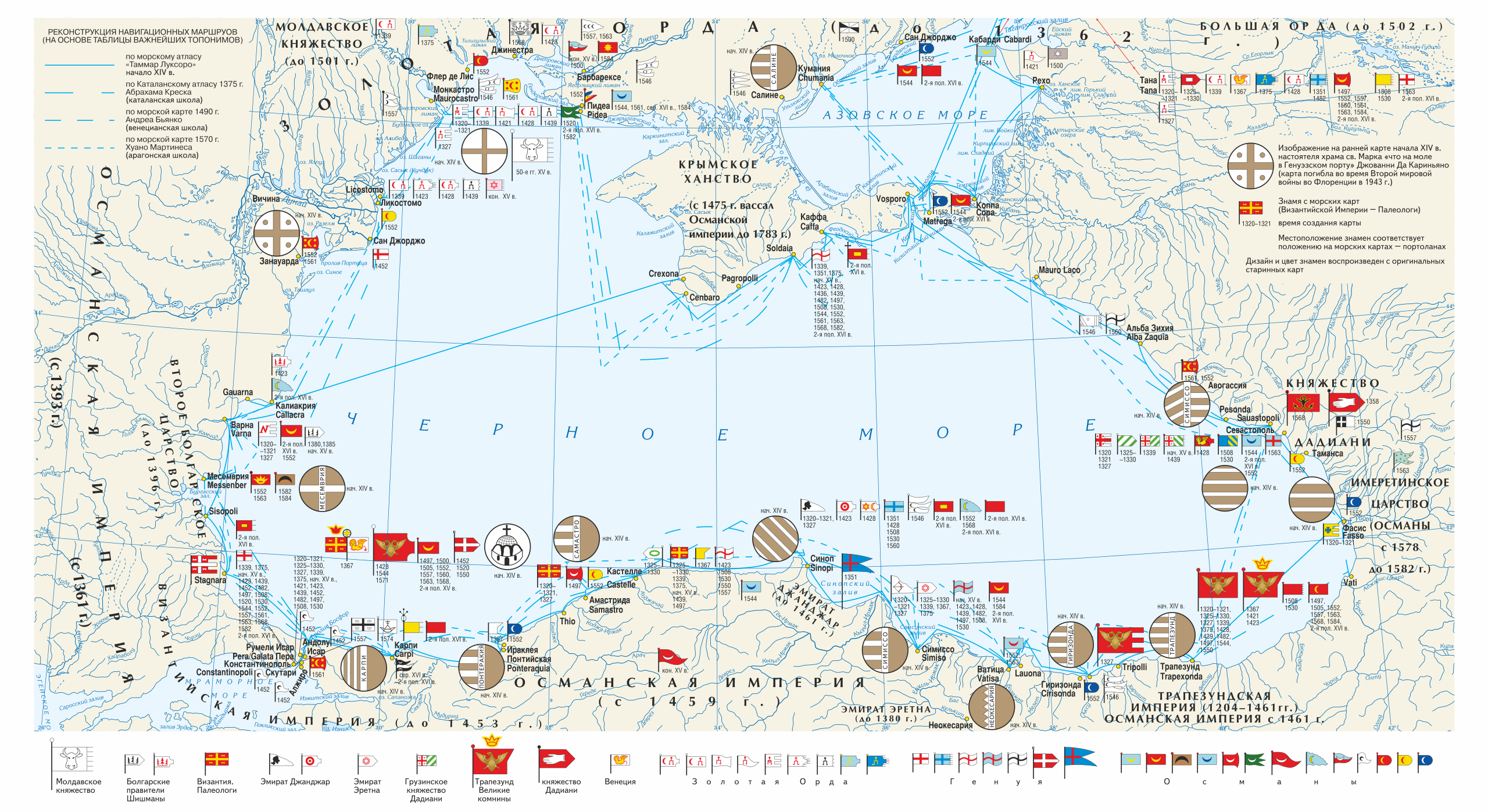
Русский: Векселлографическая карта-реконструкция Причерноморского региона «Флаги Причерноморских городов и государств по средневековым морским картам конца XIII — XVII вв.»
English: Vexilographic maps of Pontic littoral by the End of the 13th — the 17th Centuries. Territories and rulers (flags from right to left):
Key
|
| Date | |
| Source | Издание: Карпов С.П. История Трапезундской империи. СПб. 2007. (между стр. 32—33; 0,5 п. л.). |
| Author | Игорь Константинович Фоменко |
| Permission (Reusing this file) |
Licensing[edit]
This file is licensed under the Creative Commons Attribution-Share Alike 3.0 Unported license.
- You are free:
- to share – to copy, distribute and transmit the work
- to remix – to adapt the work
- Under the following conditions:
- attribution – You must give appropriate credit, provide a link to the license, and indicate if changes were made. You may do so in any reasonable manner, but not in any way that suggests the licensor endorses you or your use.
- share alike – If you remix, transform, or build upon the material, you must distribute your contributions under the same or compatible license as the original.
File history
Click on a date/time to view the file as it appeared at that time.
| Date/Time | Thumbnail | Dimensions | User | Comment | |
|---|---|---|---|---|---|
| current | 16:47, 28 March 2019 | | 1,640 × 895 (2.58 MB) | Niklitov (talk | contribs) | User created page with UploadWizard |
You cannot overwrite this file.
File usage on Commons
The following 7 pages use this file:
- Atlas
- User:J budissin/Uploads/BiH/2019 March 21-31
- Commons:Featured picture candidates/File:Vexilographic maps of Pontic littoral by end of 13th-17th century.svg
- Commons:Featured picture candidates/Log/April 2019
- File:Candaroğlu according to the Catalan Atlas c.1375.jpg
- File:Dadiani flag 1358.svg
- File:Flag of Semiso in Catalan atlas.svg
File usage on other wikis
The following other wikis use this file:
- Usage on en.wikipedia.org
- Usage on it.wikipedia.org
- Usage on lij.wikipedia.org
- Usage on ru.wikipedia.org
- Usage on ru.wikimedia.org
Metadata
Categories:
- Maps of the Black Sea
- SVG maps of Eurasia
- Maps showing 13th-century history
- Maps showing 14th-century history
- Maps showing 15th-century history
- Maps showing 16th-century history
- Maps showing 17th-century history
- Maps of Old Great Bulgaria
- Maps of the Principality of Moldavia
- Maps of the Byzantine Empire
- Maps of the Empire of Trebizond
- Dadiani
- SVG vexilographic maps
- Isfendiyarids
- SVG historical flags
- Heraldic flags
- Maps by Igor Fomenko
- Maps of the history of Greece
- Maps of the Ottoman Empire
- Maps of the Golden Horde
- Maps of the history of the Caucasus
- SVG maps of the history of Russia
- Maps of the history of Moldova
- English-language maps of Europe
- Russian-language maps of Europe
- 21st-century maps of the Black Sea