File:Ne mn geologic map.jpg
Jump to navigation
Jump to search
Size of this preview: 639 × 600 pixels. Other resolutions: 256 × 240 pixels | 512 × 480 pixels | 779 × 731 pixels.
Original file (779 × 731 pixels, file size: 185 KB, MIME type: image/jpeg)
Captions
Captions
Add a one-line explanation of what this file represents
Summary
[edit]
| Description |
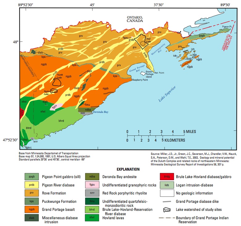
English: Bedrock geologic map of Northeastern Minnesota; prepared by the Minnesota Geological Survey and used by the USGS in, "Ground-Water/Surface-Water Interaction in Nearshore Areas of Three Lakes on the Grand Portage Reservation, Northeastern Minnesota, 2003-04" |
| Date | Map: 2002. Report: 2006. |
| Source | USGS (citing Minnesota Geological Survey): Scientific Investigations Report 2006–5034 http://pubs.usgs.gov/sir/2006/5034/pdf/SIR20065034.pdf |
| Author | Miller, J.D. Jr., Green, J.C., Severson, M.J., Chandler, W.V., Hauck, S.A., Peterson, D.M., and Wahl, T.E. Cited in report by Perry M. Jones |
| This work has been released into the public domain by its copyright holder, The Minnesota Geological Survey. This applies worldwide. In some countries this may not be legally possible; if so: The Minnesota Geological Survey grants anyone the right to use this work for any purpose, without any conditions, unless such conditions are required by law.
|
| The Minnesota Geological Survey has placed this image in the public domain with the request that credit be given to the Minnesota Geological Survey, University of Minnesota, and to the author(s) of the specific work. These images are available through the Minnesota Digital Library, "Minnesota Reflections". More information on the Minnesota Geological Survey map and report scanning project can be found here. |
Licensing
[edit]
This image is in the public domain in the United States because it only contains materials that originally came from the United States Geological Survey, an agency of the United States Department of the Interior. For more information, see the official USGS copyright policy.
|
File history
Click on a date/time to view the file as it appeared at that time.
| Date/Time | Thumbnail | Dimensions | User | Comment | |
|---|---|---|---|---|---|
| current | 06:19, 3 March 2010 | | 779 × 731 (185 KB) | Awickert (talk | contribs) | {{Information |Description={{en|1=Bedrock geologic map of Northeastern Minnesota; prepared by the Minnesota Geological Survey and used by the USGS in, "Ground-Water/Surface-Water Interaction in Nearshore Areas of Three Lakes on the Grand Portage Reservati |
You cannot overwrite this file.
File usage on Commons
There are no pages that use this file.
File usage on other wikis
The following other wikis use this file:
- Usage on de.wikipedia.org
- Usage on en.wikipedia.org
Metadata
Categories:
- Geological maps of Minnesota
- Pigeon Point Gabbro
- Pigeon River Diabase
- Rove Formation
- Puckwunge Formation
- Deronda Bay Andesite
- Red Rock Rhyolite
- Grand Portage Diabase Dike
- Grand Portage Basalt
- Hovland lavas
- Brule Lake-Hovland Diabase-Gabbro
- North Shore Volcanic Series - maps
- Duluth Complex - maps
- Volcanism of Minnesota
- Volcanological maps of the United States