File:Kabyle-speaking-map.jpg
Jump to navigation
Jump to search
No higher resolution available.
Kabyle-speaking-map.jpg (300 × 161 pixels, file size: 18 KB, MIME type: image/jpeg)
Captions
Captions
Add a one-line explanation of what this file represents
Summary[edit]
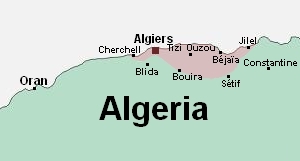
| Description | Map showing areas where Kabyle is spoken |
| Date | |
| Source | « La Kabylie rentre dans le rang », article of L'Express, 23/11/2005 |
| Author | Yoos |
| Permission (Reusing this file) |
Public Domain |
Licensing[edit]
| I, the copyright holder of this work, release this work into the public domain. This applies worldwide. In some countries this may not be legally possible; if so: I grant anyone the right to use this work for any purpose, without any conditions, unless such conditions are required by law. |
File history
Click on a date/time to view the file as it appeared at that time.
| Date/Time | Thumbnail | Dimensions | User | Comment | |
|---|---|---|---|---|---|
| current | 18:29, 16 June 2006 | | 300 × 161 (18 KB) | Masen (talk | contribs) | {{Information |Description=map showing areas where Kabyle is spoken |Date=16 june 2006 |Author=Yoos |Permission=Public Domain }} |
You cannot overwrite this file.
File usage on Commons
The following page uses this file:
File usage on other wikis
The following other wikis use this file:
- Usage on cs.wikipedia.org
- Usage on en.wikipedia.org
- Usage on it.wikipedia.org
- Usage on ja.wikipedia.org