File:KENT-77D527, Late Mesolithic to earlier Neolithic waste flake with fossil embedded in basal ventral surface (fossil also viewed here in dorsal view) (FindID 118952).jpg
Jump to navigation
Jump to search

Size of this preview: 309 × 598 pixels. Other resolutions: 124 × 240 pixels | 248 × 480 pixels | 876 × 1,696 pixels.
Original file (876 × 1,696 pixels, file size: 223 KB, MIME type: image/jpeg)
Captions
Captions
Add a one-line explanation of what this file represents
Summary[edit]
| KENT-77D527: Late Mesolithic to earlier Neolithic waste flake with fossil embedded in basal ventral surface (fossil also viewed here in dorsal view) | |||
|---|---|---|---|
| Photographer |
The Portable Antiquities Scheme, Andrew Richardson, 2006-02-01 11:02:12 |
||
| Title |
KENT-77D527: Late Mesolithic to earlier Neolithic waste flake with fossil embedded in basal ventral surface (fossil also viewed here in dorsal view) |
||
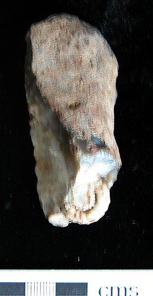
| Description |
English: Waste flake, probably of late Mesolithic or early Neolithic date due to the quantity of blades and blade cores present at the same find spot. 30% of the surface is covered in cortex. The exposed light grey flint contains a prominant fossil at the ventral basal end. The flint is unpatinated and has some post-depositional damage due to agricultural activity (chipped edges). The dimensions are 68.60mm long, 31.04mm wide, 15.97mm thick and weighs 33.09 grams. |
||
| Depicted place | (County of findspot) Kent | ||
| Date | between 6500 BC and 2900 BC | ||
| Accession number |
FindID: 118952 Old ref: KENT-77D527 Filename: PAK157-032.JPG |
||
| Credit line |
|
||
| Source |
https://finds.org.uk/database/ajax/download/id/91062 Catalog: https://finds.org.uk/database/images/image/id/91062/recordtype/artefacts archive copy at the Wayback Machine Artefact: https://finds.org.uk/database/artefacts/record/id/118952 |
||
| Permission (Reusing this file) |
Attribution-ShareAlike License | ||
| Other versions |
|
||
.jpg)
_(FindID_118952).jpg&action=edit§ion=1)
| Object location | | View this and other nearby images on: OpenStreetMap |
|---|
_(FindID_118952).jpg¶ms=051.104600_N_0001.114500_E_globe:Earth_class:object_type:object__&language=en)
Licensing[edit]
_(FindID_118952).jpg&action=edit§ion=2)
This file is licensed under the Creative Commons Attribution-Share Alike 2.0 Generic license.
Attribution: The Portable Antiquities Scheme/ The Trustees of the British Museum
- You are free:
- to share – to copy, distribute and transmit the work
- to remix – to adapt the work
- Under the following conditions:
- attribution – You must give appropriate credit, provide a link to the license, and indicate if changes were made. You may do so in any reasonable manner, but not in any way that suggests the licensor endorses you or your use.
- share alike – If you remix, transform, or build upon the material, you must distribute your contributions under the same or compatible license as the original.
File history
Click on a date/time to view the file as it appeared at that time.
| Date/Time | Thumbnail | Dimensions | User | Comment | |
|---|---|---|---|---|---|
| current | 13:04, 5 February 2017 | | 876 × 1,696 (223 KB) | Fæ (talk | contribs) | Portable Antiquities Scheme, KENT, FindID: 118952, mesolithic, page 4435, batch direction-asc count 59888 |
You cannot overwrite this file.
File usage on Commons
The following 2 pages use this file:
- File:KENT-77D527, Late Mesolithic to earlier Neolithic waste flake with fossil embedded in basal ventral surface (FindID 118952).jpg
- File:KENT-77D527, Late Mesolithic to earlier Neolithic waste flake with fossil embedded in basal ventral surface (fossil also viewed here in dorsal view) (FindID 118952).jpg
_(FindID_118952).jpg)
_(FindID_118952).jpg&oldid=736841282)