File:Gaia’s first sky map, annotated.png
Jump to navigation
Jump to search
Size of this preview: 800 × 500 pixels. Other resolutions: 320 × 200 pixels | 640 × 400 pixels | 1,024 × 640 pixels | 1,280 × 800 pixels | 1,920 × 1,200 pixels.
Original file (1,920 × 1,200 pixels, file size: 1.23 MB, MIME type: image/png)
Captions
Captions
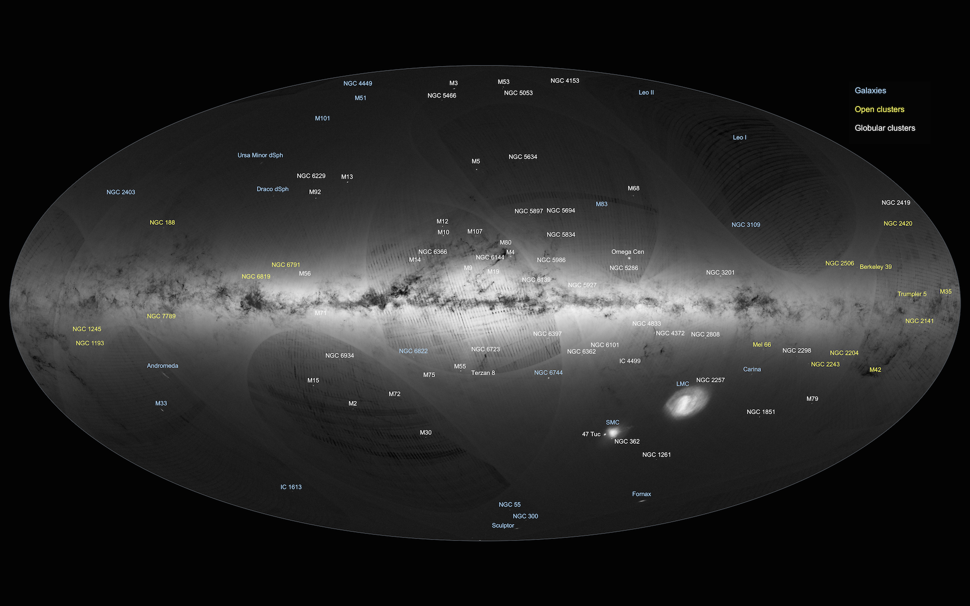
An all-sky view of stars in the Milky Way and neighbouring galaxies, based on the first year of observations from ESA’s Gaia satellite, from July 2014 to September 2015.
Summary[edit]
| Description |
English: An all-sky view of stars in the Milky Way and neighbouring galaxies, based on the first year of observations from ESA’s Gaia satellite, from July 2014 to September 2015.
This map shows the density of stars observed by Gaia in each portion of the sky. Brighter regions indicate denser concentrations of stars, while darker regions correspond to patches of the sky where fewer stars are observed. Darker regions across the Galactic Plane correspond to dense clouds of interstellar gas and dust that absorb starlight along the line of sight. The two bright objects in the lower right of the image are the Large and Small Magellanic Clouds, two dwarf galaxies orbiting the Milky Way. Other nearby galaxies are also visible, most notably Andromeda (also known as M31), the largest galactic neighbour to the Milky Way, in the lower left of the image. Below Andromeda is its satellite, the Triangulum galaxy (M33). |
| Date | |
| Source | http://www.esa.int/ESA_Multimedia/Images/2016/09/Gaia_s_first_sky_map_annotated |
| Author | ESA/Gaia/DPAC |
Licensing[edit]
This file is licensed under the Creative Commons Attribution-Share Alike 3.0 Unported license.
- You are free:
- to share – to copy, distribute and transmit the work
- to remix – to adapt the work
- Under the following conditions:
- attribution – You must give appropriate credit, provide a link to the license, and indicate if changes were made. You may do so in any reasonable manner, but not in any way that suggests the licensor endorses you or your use.
- share alike – If you remix, transform, or build upon the material, you must distribute your contributions under the same or compatible license as the original.
File history
Click on a date/time to view the file as it appeared at that time.
| Date/Time | Thumbnail | Dimensions | User | Comment | |
|---|---|---|---|---|---|
| current | 18:09, 31 May 2021 | | 1,920 × 1,200 (1.23 MB) | Artem.G (talk | contribs) | Uploaded a work by ESA/Gaia/DPAC from http://www.esa.int/ESA_Multimedia/Images/2016/09/Gaia_s_first_sky_map_annotated with UploadWizard |
You cannot overwrite this file.
File usage on Commons
There are no pages that use this file.