File:Democratic Republic of Georgia map.jpg
Jump to navigation
Jump to search
Size of this preview: 800 × 561 pixels. Other resolutions: 320 × 224 pixels | 640 × 448 pixels | 1,024 × 718 pixels | 1,213 × 850 pixels.
Original file (1,213 × 850 pixels, file size: 442 KB, MIME type: image/jpeg)
Captions
Captions
Add a one-line explanation of what this file represents

|
This history map image could be re-created using vector graphics as an SVG file. This has several advantages; see Commons:Media for cleanup for more information. If an SVG form of this image is available, please upload it and afterwards replace this template with
{{vector version available|new image name}}.
It is recommended to name the SVG file “Democratic Republic of Georgia map.svg”—then the template Vector version available (or Vva) does not need the new image name parameter. |


Summary[edit]
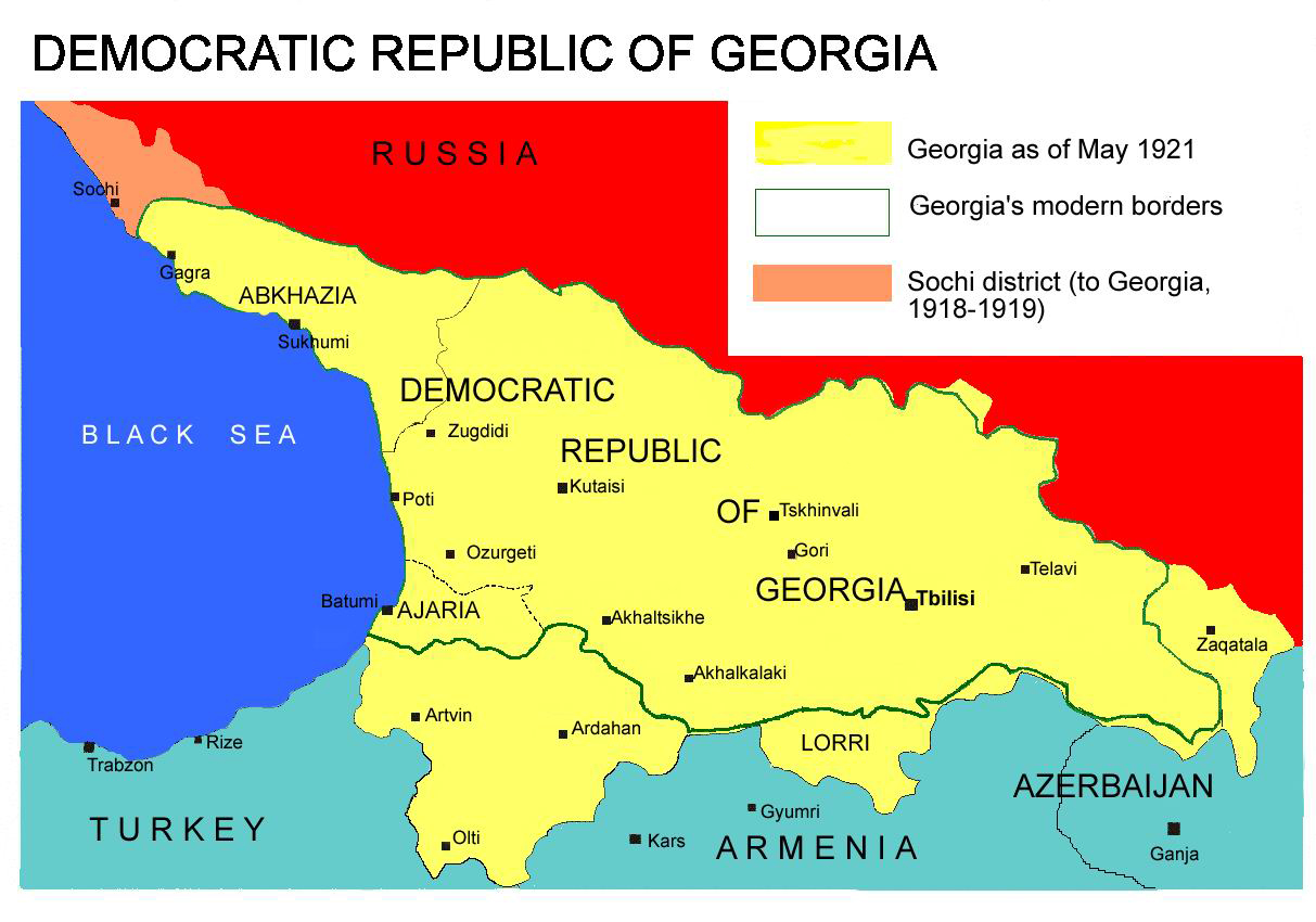
Democratic Republic of Georgia map, 1918-1921
Source: english wikipedia
Uploaded by user:Kober
Licensing[edit]
| I, the copyright holder of this work, release this work into the public domain. This applies worldwide. In some countries this may not be legally possible; if so: I grant anyone the right to use this work for any purpose, without any conditions, unless such conditions are required by law. |
File history
Click on a date/time to view the file as it appeared at that time.
| Date/Time | Thumbnail | Dimensions | User | Comment | |
|---|---|---|---|---|---|
| current | 13:26, 7 April 2013 | | 1,213 × 850 (442 KB) | Giorgi Balakhadze (talk | contribs) | At that time (May, 1921 year) there was no South Ossetia, it was created in 1922. |
| 13:21, 7 April 2013 |  | 1,213 × 850 (442 KB) | Giorgi Balakhadze (talk | contribs) | Reverted to version as of 13:08, 7 April 2013 | |
| 13:15, 7 April 2013 |  | 1,213 × 850 (442 KB) | Giorgi Balakhadze (talk | contribs) | At that time (1921 year) there was no South Ossetia, it was created 1922. | |
| 13:08, 7 April 2013 |  | 1,213 × 850 (442 KB) | Giorgi Balakhadze (talk | contribs) | At that time (1921 year) there was no South Osetia. | |
| 16:46, 26 December 2005 |  | 1,213 × 850 (111 KB) | Hardscarf (talk | contribs) | Democratic Republic of Georgia map, 1918-1921 Source: [http://en.wikipedia.org/wiki/Image:Democratic_Republic_of_Georgia_map.jpg english wikipedia] Uploaded by [http://en.wikipedia.org/wiki/User:Kober user:Kober] Category:Historical maps of Georgia |
You cannot overwrite this file.
File usage on Commons
The following page uses this file:
File usage on other wikis
The following other wikis use this file:
- Usage on bg.wikipedia.org
- Usage on bn.wikipedia.org
- Usage on da.wikipedia.org
- Usage on de.wikipedia.org
- Usage on en.wikipedia.org
- Usage on en.wikibooks.org
- Usage on fa.wikipedia.org
- Usage on id.wikipedia.org
- Usage on ka.wikipedia.org
- Usage on lt.wikipedia.org
- Usage on pl.wikipedia.org
- Usage on pnb.wikipedia.org
- Usage on pt.wikipedia.org
- Usage on ru.wikipedia.org
- Usage on sk.wikipedia.org
- Usage on sr.wikipedia.org
- Usage on tr.wikipedia.org
- Usage on uk.wikipedia.org
- Usage on ur.wikipedia.org
- Usage on zh.wikipedia.org